1) Digital Elevation Model (DEM) and Mapping | 2) Land Use Monitoring and Land Cover Classification | 3) Disaster Monitoring | 4) Geological Surveying and Mineral Resource Exploration | 5) Terrestrial Ecosystem and Forestry Management | 6) Oceanography and Coastal Zone Related Research | 7) Snow and Ice Related Research | 8) Agriculture Management | 9) Hydrology and Water Resource Management | 10) Application Research using Geographical Information | 11) PRISM / AVNIR-2 | 12) PALSAR | 13) Thailand (JAXA-GISTDA collaboration)
3) Disaster Monitoring 2010
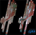
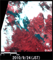
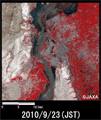
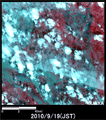
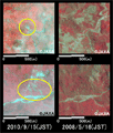
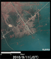
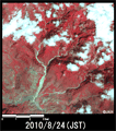
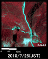
Emergency Observation of heavy rain at Amami Oshima in Japan by AVNIR-2 onboard "Daichi" (ALOS) (2)
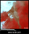
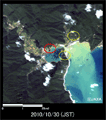
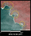
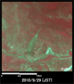
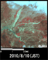
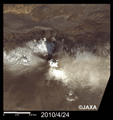
Emergency Observation of Mount Merapi Eruption in Indonesia by AVNIR-2 onboard "Daichi" (ALOS)
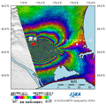
Emergency Observation of Tsunami in Indonesia by PRISM and AVNIR-2 onboard "Daichi" (ALOS)
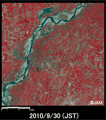
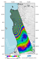
Calculation of flooded area caused by heavy rain in Pakistan
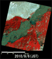
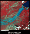
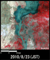
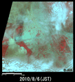
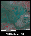
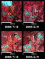
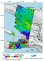
Observation of concentrated heavy rain in Pakistan by AVNIR-2 onboard "Daichi" (ALOS) (10)
Emergency Observation of mudslides in Mexico by AVNIR-2 onboard "Daichi" (ALOS)
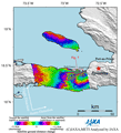
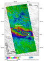
ALOS/PALSAR Observation Results of the Magnitude-7.0 Earthquake in the South Island of New Zealand in 2010 (1).
Emergency Observation of flood damage in Slovenia by AVNIR-2 onboard "Daichi" (ALOS)
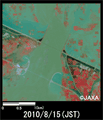
Observation of concentrated heavy rain in Pakistan by AVNIR-2 onboard "Daichi" (ALOS) (9)
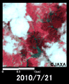
Emergency observation of concentrated heavy rain in India by AVNIR-2 onboard "Daichi" (ALOS)
Observation of mudslides in Guatemala by AVNIR-2 onboard "Daichi" (ALOS)
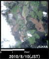
Observation of concentrated heavy rain in Pakistan by AVNIR-2 onboard "Daichi" (ALOS) (8)
Observation of concentrated heavy rain in Pakistan by AVNIR-2 onboard "Daichi" (ALOS) (7)
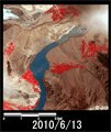
Observation of concentrated heavy rain in Pakistan by AVNIR-2 onboard "Daichi" (ALOS) (6)
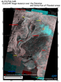
Observation of the concentrated heavy rain in Pakistan using PALSAR onboard "Daichi" (ALOS) (4)
Emergency observation of mudslides in Gansu Province China by AVNIR-2 onboard "Daichi" (ALOS) (2)
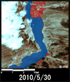
Observation of concentrated heavy rain in Pakistan by AVNIR-2 onboard "Daichi" (ALOS) (5)
Observation of concentrated heavy rain in Pakistan by AVNIR-2 onboard "Daichi" (ALOS) (4)
Emergency observation of concentrated heavy rain in Central Europe by AVNIR-2 onboard "Daichi" (ALOS)
Emergency observation of mudslides in Gansu Province China by AVNIR-2 onboard "Daichi" (ALOS)
Emergency observation of concentrated heavy rain in Pakistan by AVNIR-2 onboard "Daichi" (ALOS) (3)
Emergency observation of concentrated heavy rain in Pakistan by AVNIR-2 onboard "Daichi" (ALOS) (2)
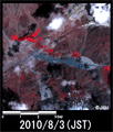
Emergency observation of concentrated heavy rain in Pakistan by AVNIR-2 onboard "Daichi" (ALOS)
Emergency observation of mudslides in the Kingdom of Bhutan by AVNIR-2 onboard "Daichi" (ALOS).
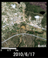
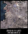
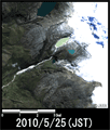
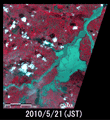
Emergency observation of concentrated heavy rain in Hiroshima Prefecture by AVNIR-2 onboard "Daichi" (ALOS) (2).
Emergency observation of concentrated heavy rain in Kinki region by AVNIR-2 onboard "Daichi" (ALOS).
Follow-up Observation of Haiti Earthquake by PRISM and AVNIR-2 onboard "Daichi" (ALOS) (3)
Emergency Observation of Floods in the Southern France by AVNIR-2 onboard "Daichi" (ALOS).
Observation of the Natural Dam Caused by Landslide in Pakistan by PRISM and AVNIR-2 onboard "Daichi" (ALOS) (2)
Follow-up Observation of Haiti Earthquake by PRISM and AVNIR-2 onboard "Daichi" (ALOS) (2)
Emergency Observation of the Natural Dam Caused by Landslide in Pakistan by AVNIR-2 onboard "Daichi" (ALOS).
Follow-up Observation of the Glacial Lake Outburst Flood (GLOF) Damage in the Andean Cordilleras, Peru by AVNIR-2 onboard "Daichi" (ALOS).
Emergency Observation of Flooding In the southern Poland by AVNIR-2 onboard "Daichi" (ALOS).
Follow-up observation of Haiti Earthquake by PRISM and AVNIR-2 onboard "Daichi" (ALOS).
Follow-up Observation of the Magnitude 8.8 Earthquake in Chile, 2010 by AVNIR-2 onboard "Daichi" (ALOS)
Emergency observation of concentrated heavy rain in Tajikistan by AVNIR-2 onboard "Daichi" (ALOS).
Emergency observation of the eruption of the Eyjafjallajökull volcano in Iceland by AVNIR-2 onboard "Daichi" (ALOS) (2).
Observation Results of ALOS/PALSAR Relating to the Magnitude 8.8 Earthquake in Chile, 2010 (2).
Emergency observation of the eruption of the Eyjafjallajökull volcano in Iceland by AVNIR-2 onboard "Daichi" (ALOS).
Observation Results of ALOS/PALSAR Relating to the Magnitude 6.9 Earthquake in Qinghai, China, 2010.
Observation Results of ALOS/PALSAR Relating to the Magnitude 8.8 Earthquake in Chile, 2010 (1).
Observation Results of ALOS/PALSAR Relating to the Magnitude 7.0 Earthquake in Haiti (2).