


1) Digital Elevation Model (DEM) and Mapping | 2) Land Use Monitoring and Land Cover Classification | 3) Disaster Monitoring | 4) Geological Surveying and Mineral Resource Exploration | 5) Terrestrial Ecosystem and Forestry Management | 6) Oceanography and Coastal Zone Related Research | 7) Snow and Ice Related Research | 8) Agriculture Management | 9) Hydrology and Water Resource Management | 10) Application Research using Geographical Information | 11) PRISM / AVNIR-2 | 12) PALSAR | 13) Thailand (JAXA-GISTDA collaboration)
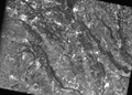
PALSAR
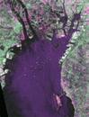
Around Nagoya, Japan image observed by PALSAR (Polarimetric) on Apr. 26, 2006.
PALSAR
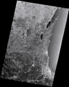
Around Lake Michigan, U.S.A. image observed by PALSAR on Apr. 11, 2006.
PALSAR
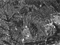
Hatoyama Town, Hiki-gun, Saitama Pref., Japan observed by PALSAR on Apr. 27, 2006.
PALSAR
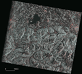
Border of Germany (Freistaat Bayern) and Austria (Bundesland Salzburg) observed by PALSAR (FBD) on Apr. 25, 2006.
PALSAR
Watarase area, Japan acquired by PALSAR (FBS, 34.3deg.) on Apr. 27, 2006.
PALSAR
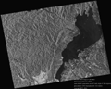
The image data on Lake Biwa in Shiga Prefecture was observed by the PALSAR on Mar. 21, 2006.
PALSAR
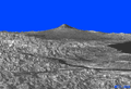
The image data of Mt. Fuji and Izu Peninsular and Shizuoka City was observed by the PALSAR on Feb. 15, 2006.