1) Digital Elevation Model (DEM) and Mapping | 2) Land Use Monitoring and Land Cover Classification | 3) Disaster Monitoring | 4) Geological Surveying and Mineral Resource Exploration | 5) Terrestrial Ecosystem and Forestry Management | 6) Oceanography and Coastal Zone Related Research | 7) Snow and Ice Related Research | 8) Agriculture Management | 9) Hydrology and Water Resource Management | 10) Application Research using Geographical Information | 11) PRISM / AVNIR-2 | 12) PALSAR | 13) Thailand (JAXA-GISTDA collaboration)
3) Disaster Monitoring 2009
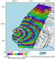
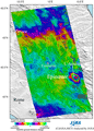
Observation Results of ALOS/PALSAR Relating to the Magnitude 7.6 Earthquake in the South Island, New Zealand (2).
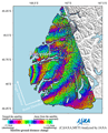
Observation Results of ALOS/PALSAR Relating to the Magnitude 7.6 Earthquake in the South Island, New Zealand.
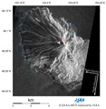
Observation Results of ALOS/PALSAR Relating to the Eruption at Sarychev Peak, Kuril Islands, in June 2009.
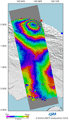
Observation Results of ALOS/PALSAR relating to the magnitude 6.3 Earthquake in Central Italy.