


1) Digital Elevation Model (DEM) and Mapping | 2) Land Use Monitoring and Land Cover Classification | 3) Disaster Monitoring | 4) Geological Surveying and Mineral Resource Exploration | 5) Terrestrial Ecosystem and Forestry Management | 6) Oceanography and Coastal Zone Related Research | 7) Snow and Ice Related Research | 8) Agriculture Management | 9) Hydrology and Water Resource Management | 10) Application Research using Geographical Information | 11) PRISM / AVNIR-2 | 12) PALSAR | 13) Thailand (JAXA-GISTDA collaboration)
PRISM
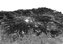
The image data of Mt. Haruna was observed by the PRISM on Feb. 14, 2006.
AVNIR-2
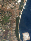
The image data of Osumi Peninsula in Kagoshima Prefecture was observed by the AVNIR-2 on Feb. 17, 2006.
AVNIR-2
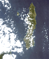
The image data of Tanegashima Island in Kagoshima Prefecture was observed by the AVNIR-2 on Feb. 17, 2006.
PRISM
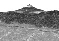
The image data of Mt. Fuji was observed by the PRISM on Feb.14, 2006 and a three-dimensional movie compiled from observed images.
PRISM
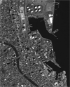
The image data of Shimizu Port near Shizuoka city was observed by the PRISM on Feb.14, 2006