Zhouqu County, Gannan Tibetan Autonomous Prefecture, Gansu Province in northwest China was seriously damaged due to massive rain-triggered mudslides on August 8, 2010. The Japan Aerospace Exploration Agency (JAXA) has performed the emergency observation to monitor the state of the damage by the Advanced Visible and Near Infrared Radiometer type 2 (AVNIR-2)* onboard the Advanced Land Observing Satellite (ALOS, "Daichi") at 12:51 (JST) or 3:51 (UTC) on August 24, 2010 further to August 10, 2010.
Fig. 1 shows an observed image and is assigned band 3, 2 and 1 of AVNIR-2 for red, green and blue as the true color composite. What sees white is cloud.
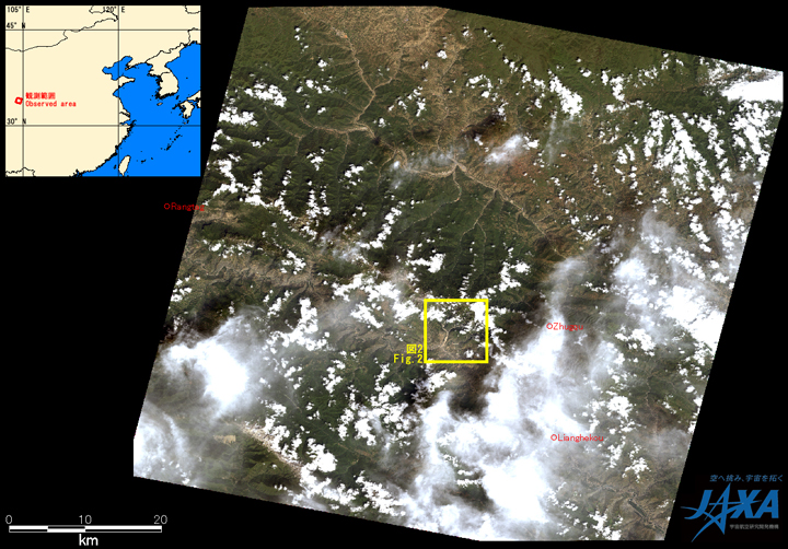
Fig.1: AVNIR-2 image with -4.0 degrees pointing angle acquired at 12:51 on August 24, 2010 (JST).
Yellow square shows location of Fig. 2.
(Click to View Enlarged Image)
Fig. 2 shows comparative images which were taken after disaster on August 23, 2010 (left) and before disaster March 10, 2010 (right). It is assigned band 4, 3 and 2 of AVNIR-2 for red, green and blue as the false color composite, therefore vegetation can be seen in red color and areas where vegetation is lost due to mudslides. Yellow circled areas in the image taken on August 24, 2010 indicate that mudslides occurred. The areas shown by green circles in the image taken on August 24, 2010 couldn't be seen in the image taken on August 10, 2010 due to clouds, however the image taken on August 24, 2010 indicates vegetation was lost and mudslides occurred.
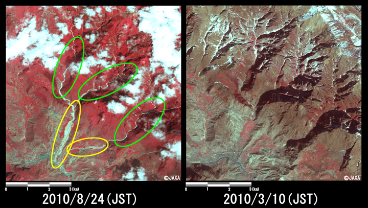
Fig.2: Enlarged images of the mudslides at Sanyan Cun
(64 square kilometers, left: August 24, 2010; right: March 10, 2010).
(Click to View Enlarged Image)
JAXA plans continuous observation of this area.
The acquired images were provided to "Ministry of Land, Infrastructure, Transport and Tourism" and "National Institute for land and Infrastructure Management".
* Advanced Visible and Near Infrared Radiometer type 2 (AVNIR-2):
AVNIR-2 is a visible and near infrared radiometer for observing land and coastal zones.
It provides 10-m spatial-resolution image and 70-km swath on the ground. The pointing angle of AVNIR-2 is +44 and - 44 degrees. This image was acquired by 4.0 degrees west. The image taken before disaster on March 10, 2010 was acquired by 0.0 degree.
[Reference]
2010/8/11: Emergency observation of mudslides in Gansu Province China by AVNIR-2 onboard "Daichi" (ALOS).
©JAXA EORC
Copyright©1997- JAXA EORC All rights reserved.