The mudslides and floods occurred on May 6 to 7 2010 in Southern-Tajikistan of Central Asia due to the concentrated heavy rains and melting snow. The Japan Aerospace Exploration Agency (JAXA) has decided to observe here by the Advanced Visible and Near Infrared Radiometer type 2 (AVNIR-2) onboard the Advanced Land Observation Satellite (ALOS, "Daichi") at 6:32 (UTC) on May 11, 2010 as an emergency observation.
Fig. 1 shows an observed image of AVNIR-2 at 6:32 (UTC) on May 11, 2010. This indicates swollen rivers and mudslide at several areas. Fig. 1 assigned by channel 3, 2, 1 for red, green, blue colors as true color composite, therefore white colored areas show clouds.
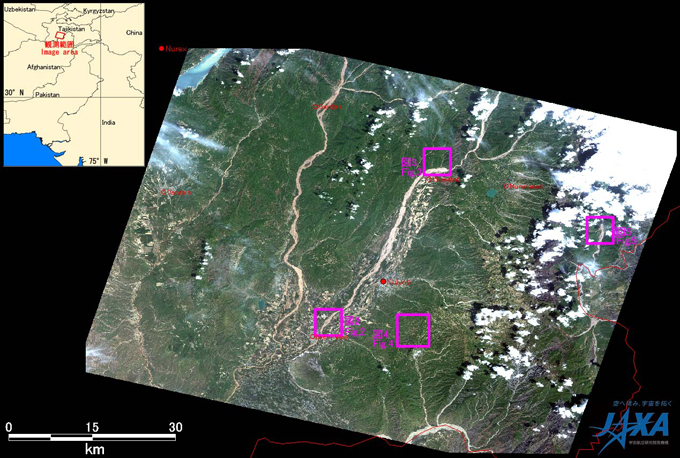
Fig.1: AVNIR-2 image with +25 degrees pointing angle acquired on 6:32 of May 11, 2010.
Purple squares show locations of Figs. 2 to 5.
(Click to View Enlarged Image)
Fig. 2 shows the enlarged images around Imeni Vose in the southern part of Tajikistan, which are taken after disaster on May 11, 2010 (left) and just one month before disaster on April 14, 2010 (right). In comparison to the images, the image taken after disaster indicates that the rivers swelled and their width became wide shown by red circles. And several farmlands and homes might be inundating from the image after disaster.
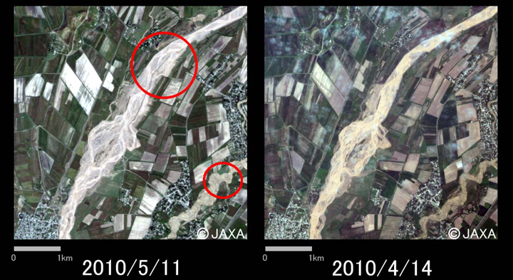
Fig.2: Enlarged image around Imeni Vose (5km square, left: May 11, 2010; right: April 14, 2010).
(Click to View Enlarged Image)
Fig. 3 shows the enlarged image of mudslides in Khanabad with a red circle. In the right image of Fig. 3 taken just one month before the disaster, the area was covered by vegetations as seen by green colors. However, a mountain surfaces were cut by mudslides in the left image taken after disaster. Therefore, these might be caused by the heavy rains.
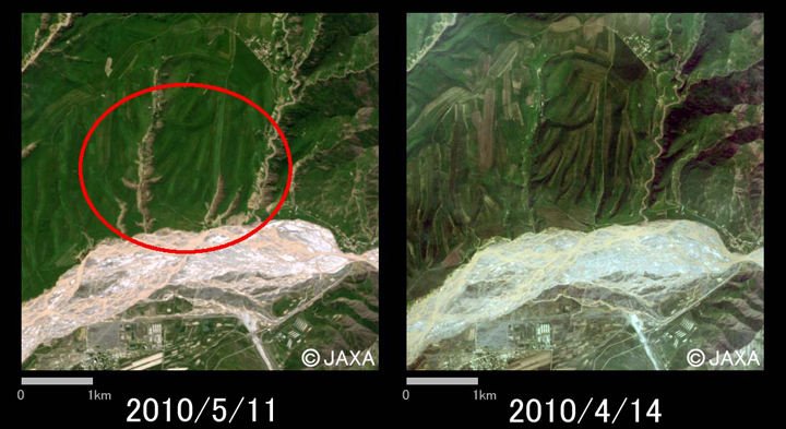
Fig.3: Mudslides in Khanabad (5km square, left: May 11, 2010; right: April 14, 2010).
(Click to View Enlarged Image)
Fig. 4 shows also the enlarged image of mudslides around Chagam, which were taken after disaster on May 11, 2010 (left) and before disaster on April 14, 2010 (right). There were likely to touch off mudslides at these areas even in the before disaster. However, these mudslides were taken places at the disaster because the number of mountain surfaces of left image is more than one of the right as shown in red circles.
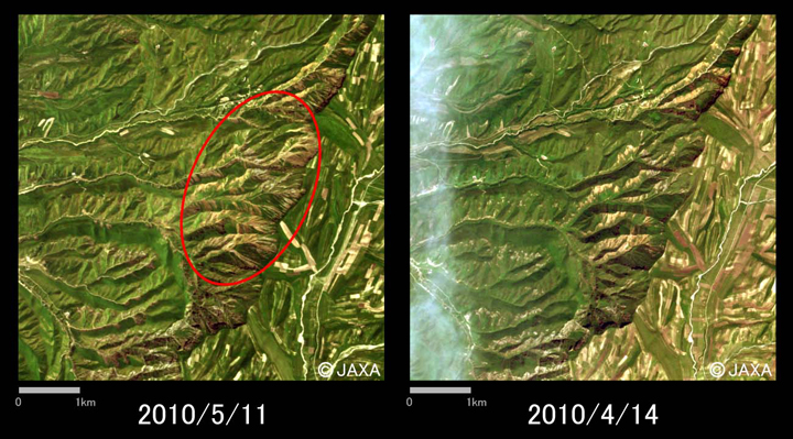
Fig.4: Large mudslides in Chagam (6km square, left: May 11, 2010; right: April 14, 2010).
(Click to View Enlarged Image)
Fig. 5 shows flooding area enlarged in Dashtidzhum. The red circle of left image shows inundation area as seen in brown color. The width of the river connected here became wider compared with the right image on March 28, 2010.
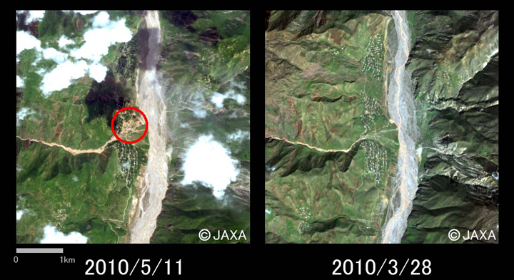
Fig.5: Flooding area in Dashtidzhum (5km square, left: May 11, 2010; right: March 28, 2010).
(Click to View Enlarged Image)
The acquired images were provided to Committee of Emergency Situation and Civil Defense, Tajikistan via the "Sentinel Asia".
*1 Advanced Visible and Near Infrared Radiometer type 2 (AVNIR-2):
AVNIR-2 is visible sensor that 4 bands of visible and near infrared radiometer for observing land and coastal zones. The pointing angle of AVNIR-2 is +44 and - 44 degrees.
©JAXA EORC
Copyright©1997- JAXA EORC All rights reserved.