1) Digital Elevation Model (DEM) and Mapping | 2) Land Use Monitoring and Land Cover Classification | 3) Disaster Monitoring | 4) Geological Surveying and Mineral Resource Exploration | 5) Terrestrial Ecosystem and Forestry Management | 6) Oceanography and Coastal Zone Related Research | 7) Snow and Ice Related Research | 8) Agriculture Management | 9) Hydrology and Water Resource Management | 10) Application Research using Geographical Information | 11) PRISM / AVNIR-2 | 12) PALSAR | 13) Thailand (JAXA-GISTDA collaboration)
3) Disaster Monitoring 2011
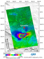
Observation results of flooding in Thailand by Pi-SAR-L (L-band-Polarimetric and interferometry-Synthetic Aperture Radar).
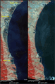
Observation results of flooding in Thailand by airborne SAR sensor (Pi-SAR-L: L-band-Polarimetric and interferometry-Synthetic Aperture Radar)(2).
Observation results of flooding in Thailand by airborne SAR sensor (Pi-SAR-L: L-band-Polarimetric and interferometry-Synthetic Aperture Radar).
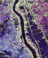
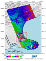
ALOS/PALSAR Observation Results of the Magnitude-9.0 Earthquake off the Pacific coast of Tohoku-Kanto District in Japan in 2011 (3).
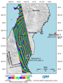
ALOS/PALSAR Observation Results of the Magnitude-9.0 Earthquake off the Pacific coast of Tohoku-Kanto District in Japan in 2011 (2).
TerraSAR-X Observation Results of the Magnitude-9.0 Earthquake off the Pacific coast of Tohoku-Kanto District in Japan in 2011.
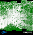
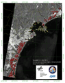
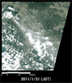
Emergency Observation of Magnitude-9.0 Earthquake off the Pacific coast of Tohoku-Kanto District in Japan in 2011 by AVNIR-2 onboard "Daichi" (ALOS).
ALOS/PALSAR Observation Results of the Magnitude-9.0 Earthquake off the Pacific coast of Tohoku-Kanto District in Japan in 2011.
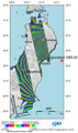
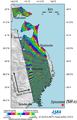
ALOS/PALSAR Observation Results of the Magnitude-6.3 Earthquake in the South Island of New Zealand in 2011.
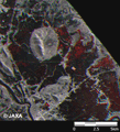
Emergency Observation of Shinmoedake peak (Kirishima Volcanic Range) Eruption by AVNIR-2 onboard "Daichi" (ALOS).