Following the emergency observation on April 17, 2010, the Japan Aerospace Exploration Agency (JAXA) has decided to observe the Eyjafjallajökull volcano in Iceland by using the Advanced Land Observing Satellite (ALOS, "Daichi") on April 23 and 24, 2010. The images were acquired by the Advanced Visible and Near Infrared Radiometer type 2 (AVNIR-2) on April 23, and the Panchromatic Remote Sensing Instrument for Stereo Mapping (PRISM) and AVNIR-2 on April 24.
Fig. 1 shows the time-series images of AVNIR-2 for the Eyjafjallajökull volcano, which were acquired on April 24, April 23, April 21, and April 17 from left to right. The images say volcanic fumes are becoming small over time.
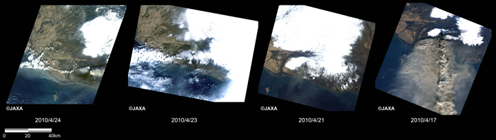
Fig.1: Time series images of AVNIR-2 in the Eyjafjallajökull volcano of Iceland
(From left to right: acquired on April 24, April 23, April 21, and April 17, 2010)
(Click to View Enlarged Image)
Fig. 2 shows the enlarged part of the crater on April 24, April 23, April 21, and April 17, 2010 from left to right. The pansharpened image by PRISM and AVNIR-2 was generated on April 24, and others were by AVNIR-2. The red circle in Fig. 2 indicates the crater area, where volcanic fumes can be identified in gray or white colors.
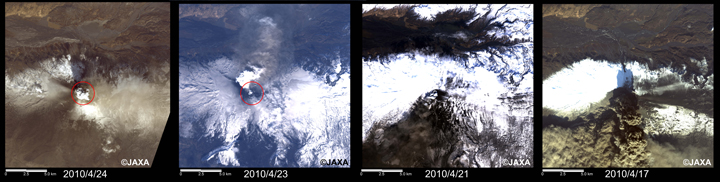
Fig.2: Enlaged images around the crater of the Eyjafjallajökull volcano
(20 km squares; From left to right: acquired on April 24, April 23, April 21, and April 17, 2010)
(Click to View Enlarged Image)
The acquired images were provided to disaster management organizations and the International Disaster Charter.
Apr. 26, 2010: Emergency observation of the eruption of the Eyjafjallajökull volcano in Iceland by AVNIR-2 onboard "Daichi" (ALOS)
©JAXA EORC
Copyright©1997- JAXA EORC All rights reserved.