At 21:53 (UTC) on January 12, 2010, a magnitude 7.0 (10km depth of epicenter) earthquake occurred Haiti in the Central America. The Japan Aerospace Exploration Agency (JAXA) had performed the emergency observations of the Advanced Land Observing Satellite (ALOS, "Daichi") to monitor the state of damage caused by the earthquake using the optical instruments on January 13 and using the 23 by PALSAR on January 13, 16 and 25.
The Panchromatic Remote Sensing Instrument for Stereo Mapping (PRISM) and the Advanced Visible and Near Infrared Radiometer type 2 (AVNIR-2) onboard the ALOS were activated to observe the recovery state on 15:32 (UTC) of May 12, 2010.
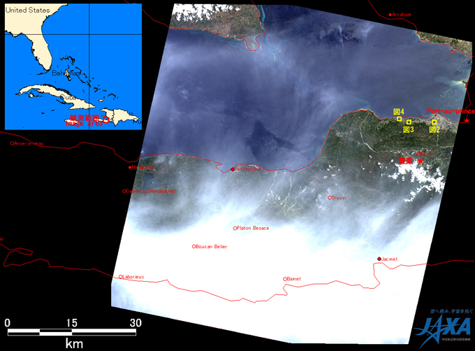
Fig.1: AVNIR-2 image with 0.0 degree pointing angle acquired on 15:32 of May 12, 2010.
Yellow squares shows location of Fig. 2 - 4.
(Click to View Enlarged Image)
Fig. 1 shows the newly acquired image at west of the capital city of Port-au-Prince in Haiti. It assigns the channel 3, 2, and 1 for red, green and blue colors as true color composite. Therefore, the white colored areas show cloud.
Fig. 2 compares the images of May 12, 2010 and March 27, 2010, which are about four and two months after the earthquake, respectively. The images are pansharpened and are generated from PRISM and AVNIR-2. Red marked areas in Fig. 2 are school (upper) and hospital (lower) respectively. New buildings can be seen in the left image while they are not seen in the image on March 27.
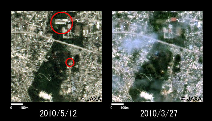
Fig.2: Enlarged image around a school and a hospital.
(750m squares, left: May 12, 2010; right: Mar. 27, 2010)
(Click to View Enlarged Image)
Fig. 3 shows the enlarged image of a town which is about 5.6 kilometers west of Fig.2. Red marked area also indicates construction of new buildings.
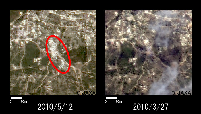
Fig.3: Enlarged image of 5.6 km west of Fig. 2.
(750m squares, left: May 12, 2010; right: Mar. 27, 2010)
(Click to View Enlarged Image)
Fig. 4 shows the enlarged image of the port at 8 kilometers west of Fig. 2. It shows possible construction of new pier.
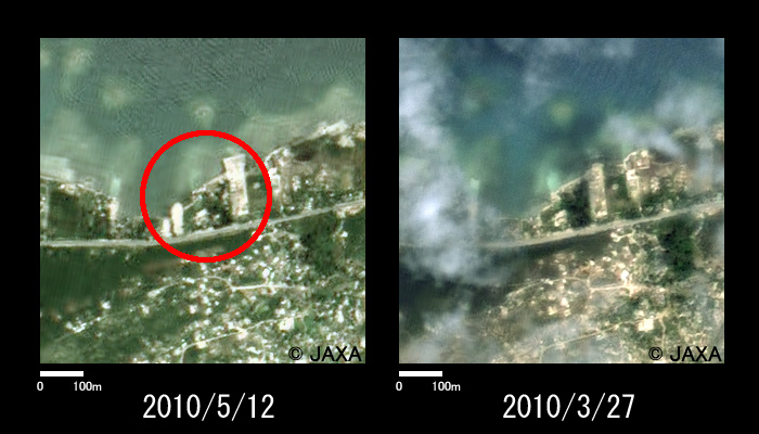
Fig.4: Enlarged image of port at 8 km west of Fig. 2.
(750m squares, left: May 12, 2010; right: Mar. 27, 2010)
(Click to View Enlarged Image)
JAXA plans continuous observation of this area.
[Reference]
2010/1/28: Observation Results of ALOS/PALSAR Relating to the Magnitude 7.0 Earthquake in Haiti (2).
2010/1/22: Observation Results of ALOS/PALSAR Relating to the Magnitude 7.0 Earthquake in Haiti (1).
©JAXA EORC
Copyright©1997- JAXA EORC All rights reserved.