After the serious rain falls in Pakistan, the end of July 2010, Japan Aerospace Exploration Agency (JAXA) has been observing the Indus River basin using the Advanced Land Observing Satellite (ALOS, "Daichi") and its high-resolution sensors to monitor the related flooded region and its temporal changes [1-8]. In order to effectively detect the flooded extents under the possible rainy and cloudy conditions, PALSAR-ScanSAR, which serves 100m resolution and 350km imaging swath with quick revisit time, is selected to this demonstration example.
Fig.1 shows the color composite of the ScanSAR mosaic data which are acquired between Aug. 5, 2010 and Aug. 29, 2010 in six times and mosaicked to 1500km geographical scale in east-west and north-south directions as the after the rain fall event and the another six-ScanSAR-data mosaic acquired between June 27, 2010 and July 19, 2010 as the before the event. Color assignments are red for before the event and green/blue for after the event so that the red color represents the flooded flat region with no- or less radar backscatter and blue color represents the increase of the radar backscatter due to the rain events. The ScanSAR data are terrain-corrected using the USGS 90 meter topography data and sloped corrected for eliminating the radar backscatter modulation due to the terrain height variation.
Indus river basin was widely inundated by these recordable heavy rain events. Fig. 2 shows the general information of the observations.
In cooperation with the World Bank, the European Commission/Joint Research Center, and the United Nations (UNOSAT,) the Asia development Bank (ADB) will support the Space Upper Atmosphere Research Commission (SUPARCO) of Pakistan to promote a survey project to recover and restore the areas using a remote sensing system and a geographic information system.
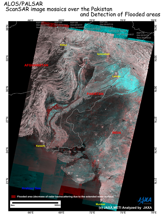
Fig.1: Color composite of the PALSAR ScanSAR mosaic: Red for before the disaster,
Green and Blue for after the disaster.
(Click to View Enlarged Image)
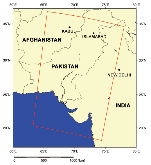
Fig.2: Location of the mosaic area in red frame.
[Reference]
2010/8/25: Observation of concentrated heavy rain in Pakistan by AVNIR-2 onboard "Daichi" (ALOS) (5).
2010/8/18: Observation of concentrated heavy rain in Pakistan by AVNIR-2 onboard "Daichi" (ALOS) (4).
2010/8/10: Emergency observation of concentrated heavy rain in Pakistan by AVNIR-2 onboard "Daichi" (ALOS) (3).
2010/8/9: Emergency observation of concentrated heavy rain in Pakistan by AVNIR-2 onboard "Daichi" (ALOS) (2).
2010/8/5: Emergency observation of concentrated heavy rain in Pakistan by AVNIR-2 onboard "Daichi" (ALOS).
©JAXA EORC
Copyright©1997- JAXA EORC All rights reserved.