


1) Digital Elevation Model (DEM) and Mapping | 2) Land Use Monitoring and Land Cover Classification | 3) Disaster Monitoring | 4) Geological Surveying and Mineral Resource Exploration | 5) Terrestrial Ecosystem and Forestry Management | 6) Oceanography and Coastal Zone Related Research | 7) Snow and Ice Related Research | 8) Agriculture Management | 9) Hydrology and Water Resource Management | 10) Application Research using Geographical Information | 11) PRISM / AVNIR-2 | 12) PALSAR | 13) Thailand (JAXA-GISTDA collaboration)
3) Disaster Monitoring 2008
Update
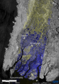
Jun. 17, 2008
PALSAR
PALSAR
Myanmar
Flood
Myanmar flood water observation by PALSAR (II).
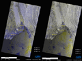
May 9, 2008
PALSAR
PALSAR
Myanmar
Flood
Myanmar flood water observation by PALSAR.