


1) Digital Elevation Model (DEM) and Mapping | 2) Land Use Monitoring and Land Cover Classification | 3) Disaster Monitoring | 4) Geological Surveying and Mineral Resource Exploration | 5) Terrestrial Ecosystem and Forestry Management | 6) Oceanography and Coastal Zone Related Research | 7) Snow and Ice Related Research | 8) Agriculture Management | 9) Hydrology and Water Resource Management | 10) Application Research using Geographical Information | 11) PRISM / AVNIR-2 | 12) PALSAR | 13) Thailand (JAXA-GISTDA collaboration)
3) Disaster Monitoring 2007
PALSAR
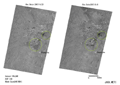
Observation Results of the Advanced Land Observing Satellite "Daichi" (ALOS) relating to 2007 Niigata-ken Chuetsu Offshore Earthquake.
PALSAR
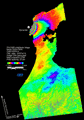
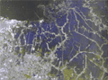
South of China Flood observation by PALSAR(SCANSAR).
PALSAR
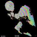
ALOS detected the surface rise at the New Georgia islands caused by Solomon earthquake.
PALSAR
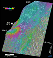
Observation Results of the 2007 Noto Peninsular Earthquake by the Advanced Land Observing Satellite "Daichi".
AVNIR-2
PALSAR
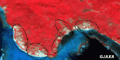
Emergency Observation on the Solomon Islands Earthquake.
PALSAR
Indonesian Flood observation by PALSAR.