A landslide occurred on January 4, 2010 in the Hunza Valley of northern Pakistan, and it blocked the Hunza River and created a dammed lake. It affected to life of the peoples living in near here. In addition, local peoples are concerning an outburst flood due to break the dam.
The Japan Aerospace Exploration Agency (JAXA) had performed observations by the Panchromatic Remote Sensing Instrument for Stereo Mapping (PRISM) and The Advanced Visible and Near Infrared Radiometer type 2 (AVNIR-2) onboard the Advanced Land Observing Satellite (ALOS, "Daichi") on 14:56 (JST) or 6:56 (UTC) of June 13, 2010 further to May 30, 2010.
Fig. 1 shows an observed AVNIR-2 image in northern Pakistan, which located about 328 km north-east from Islamabad. Fig. 1 is the true colored composite using band 3, 2, 1 of AVNIR-2. The yellow square shows the location of Fig. 2, and pinks show that of Fig. 3 to 5. Most of Fig. 1 covered by clouds, however the dammed lake region could be identified.
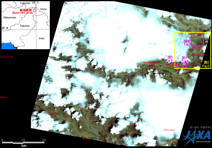
Fig.1: AVNIR-2 image with 0 degree pointing angle acquired on 14:56 of June 13, 2010 (JST).
Yellow square shows the location of Fig. 2, and pinks of Figs. 3 to 5.
(Click to View Enlarged Image)
Fig. 2 shows enlarged images around the dammed lake occurred by the landslide and the Shishkat Village. The left was a pan-sharpened image by PRISM and AVNIR-2 acquired on June 13, 2010 (160 days after the landslide), middle by AVNIR-2 on May 30, 2010 (146 days after that), and right by AVNIR-2 on September 10, 2009 (before that), respectably. This is assigned band 4, 3, 2 of AVNIR-2 as the false color composite, therefore vegetation can be seen in red color and water can be seen clear in blue color. The area of the lake could be calculated approximately 1,060 hectares from the AVNIR-2 image acquired on May 30, 2010, however it is becoming approximately 1,239 hectares from the image on June 13, 2010. Therefore, the lake is expanding during the period.
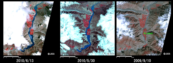
Fig.2: Enlarged image of the dammed lake around Shishkat Village
(18 km squarers area, left: June 13, 2010; middle: May 30, 2010, right: Sep. 10, 2009).
(Click to View Enlarged Image)
Fig. 3 shows an enlarged image of upper reaches of the dammed lake. The lake is expanding compared images acquired on June 13, 2010 (left) with May 30, 2010 (middle), which shows by the yellow circle in Fig. 3.
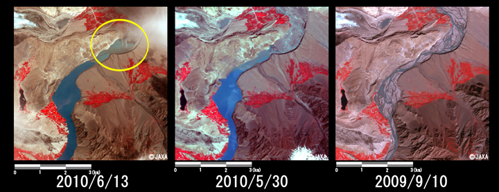
Fig.3: Enlarged image of upper reaches of the dammed lake.
(6 km squares, left: June 13, 2010; middle: May 30, 2010; right: Sep. 10, 2009).
(Click to View Enlarged Image)
Fig. 4 shows an enlarged image of down reaches of the dammed lake. The outflow from the lake can be identified the image acquired on June 13, 2010 (left). However, the area is expanding as shown in Fig. 3, thus water volume of inflow is smaller than that of outflow.
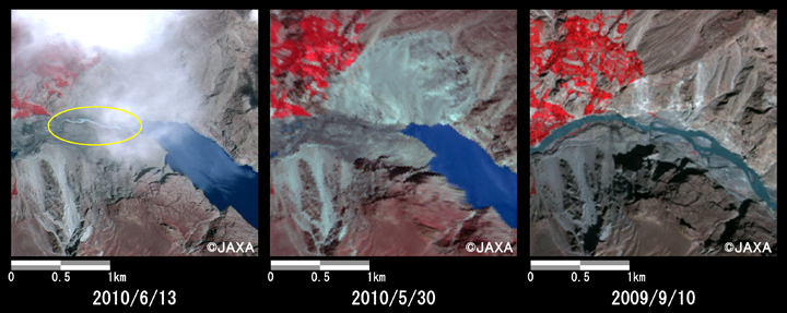
Fig.4: Enlarged image of down reaches of the dammed lake corresponds to the site of the landslide.
(2.5 km squares, left: June 13, 2010; middle: May 30, 2010; right: Sep. 10, 2009).
(Click to View Enlarged Image)
Fig. 5 shows an enlarged image of down reaches of the dammed lake. The discharge of June 13, 2010 (left) is relatively larger than that of May 30, 2010 (middle), because river width is became wide. However, it is narrower than that of Sep. 10, 2009 (right). Therefore, it looks that does not serious dangerous in downstream areas except for outburst flood.
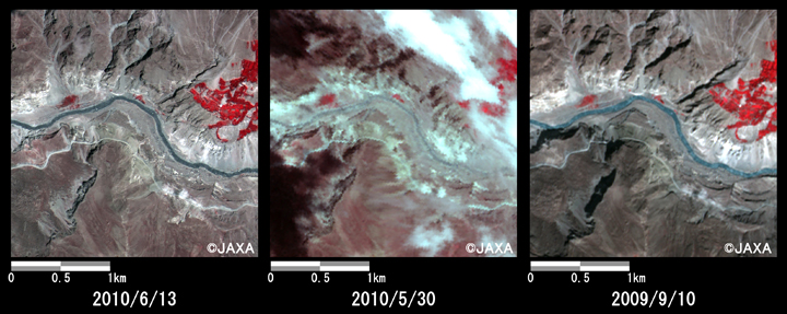
Fig.5: Enlarged image of down reaches of the dammed lake.
(2.5 km squares, left: June 13, 2010; middle: May 30, 2010; right: Sep. 10, 2009).
(Click to View Enlarged Image)
JAXA plans continuous observation of this area.
[Reference]
2010/6/7: Emergency Observation of the Natural Dam Caused by Landslide in Pakistan by AVNIR-2 onboard "Daichi" (ALOS).
©JAXA EORC
Copyright©1997- JAXA EORC All rights reserved.