The Kingdom of Bhutan was seriously damaged due to the floods and mudslides caused by monsoon rain. The Japan Aerospace Exploration Agency (JAXA) has decided to observe here by the Advanced Visible and Near Infrared Radiometer type 2 (AVNIR-2)* onboard the Advanced Land Observation Satellite (ALOS, "Daichi") at 13:54 (JST) on Jul. 25, 2010 as an emergency observation.
Fig. 1 shows an observed image of AVNIR-2 at 13:54 (JST) on Jul. 25, 2010. It assigned by channel 3, 2 and 1 for red, green and blue colors as true color composite. Although most of Fig. 1 covered by clouds (seen by white color), the damaged mudslide region could be identified.
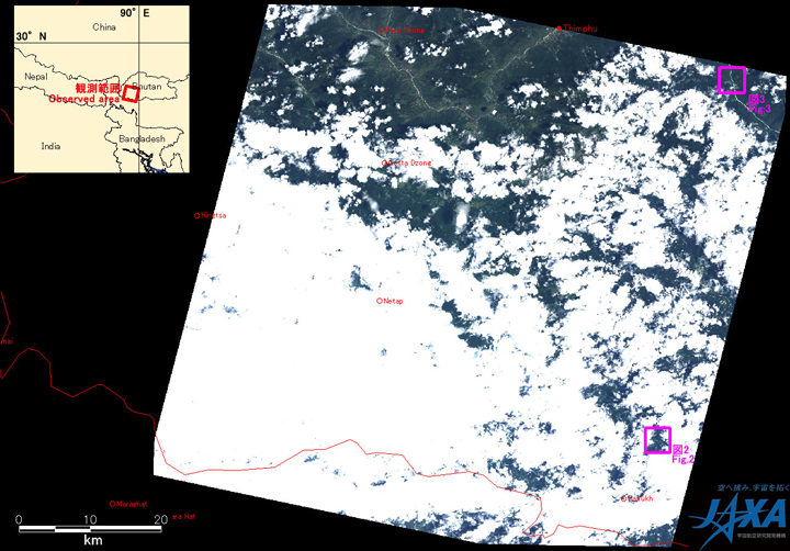
Fig.1: AVNIR-2 image with -11 degrees pointing angle acquired on 13:54 (JST) on Jul. 25, 2010.
Pink squares show locations of Figs. 2 to 3.
(Click to View Enlarged Image)
Figs. 2 and 3 show the enlarged images of AVNIR-2, which were taken after the disaster on Jul. 25, 2010 (left), and before the disaster on January 9, 2007 (center) and August 9, 2006 (right). There are assigned band 4, 3 and 2 of AVNIR-2 as the false color composite, therefore vegetation can be seen in red color. They clearly indicate the areas where vegetation was lost due to mudslides, which shows yellow circle in Figs. 2 and 3.
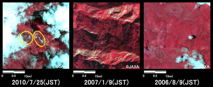
Fig.2: Enlarged images of southwest part of Tsirang pref., Buhtan.
(9 square kilometers, left: Jul. 25, 2010; center: Jan. 9, 2007; right: Aug. 9, 2006).
(Click to View Enlarged Image)
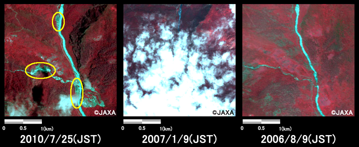
Fig.3: Enlarged images of southwest part of Wangdue Phodrang pref. Buhtan.
(9 square kilometers, left: Jul. 25, 2010; center: Jan. 9, 2007; right: Aug. 9, 2006).
(Click to View Enlarged Image)
The acquired images were provided to The International Centre for Integrated Mountain Development (ICIMODO) via the "Sentinel Asia".
JAXA plans continuous observation of this area.
* Advanced Visible and Near Infrared Radiometer type 2 (AVNIR-2):
AVNIR-2 is a visible and near infrared radiometer for observing land and coastal zones.
It provides 10-m spatial-resolution image and 70-km swath on the ground. The pointing angle of AVNIR-2 is +44 and - 44 degrees. This image was acquired by 11 degrees west.
©JAXA EORC
Copyright©1997- JAXA EORC All rights reserved.