Zhouqu County, Gannan Tibetan Autonomous Prefecture, Gansu Province in northwest China was seriously damaged due to massive rain-triggered mudslides on August 8, 2010. The Japan Aerospace Exploration Agency (JAXA) has performed the emergency observation to monitor the state of the damage by the Advanced Visible and Near Infrared Radiometer type 2 (AVNIR-2)* onboard the Advanced Land Observing Satellite (ALOS, "Daichi") at 13:13 (JST) or 4:13 (UTC) on August 10, 2010.
Fig. 1 shows an observed image and is assigned band 3, 2 and 1 of AVNIR-2 as the true color composite. Although most of the image was covered by clouds, the mudslides area could be identified through clouds.
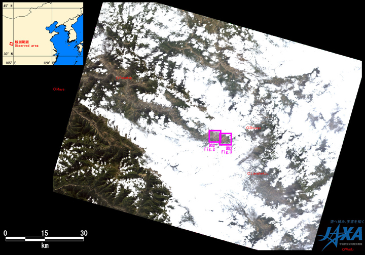
Fig.1: AVNIR-2 image with 31.0 degrees pointing angle acquired at 13:13 on August 10, 2010 (JST).
Purple squares show location of Figs. 2 and 3.
(Click to View Enlarged Image)
Fig. 2 shows comparative images which were taken after disaster on August 10, 2010 (left) and before disaster March 10, 2010 (right). This is assigned band 4, 3 and 2 of AVNIR-2 as the false color composite, therefore vegetation can be seen in red color and areas where vegetation is lost due to mudslides.
Yellow circled areas in the image taken on August 10, 2010 indicate that mudslides occurred and the mud-rock fell down to the Bailong River on the south side.
The image shows that mudslides and the swollen Bailong River blocked by the landslides reported by news were resolved by three blasts. It indicates the bridge shown by green circle was collapsed by this disaster.
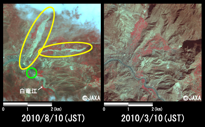
Fig.2: Enlarged images of the mudslides at Sanyan Cun
(16 square kilometers, left: August 10, 2010; right: March 10, 2010).
(Click to View Enlarged Image)
Fig. 3 shows comparative images which were taken after disaster on August 10, 2010 (left) and before disaster March 10, 2010 (right). The image taken after disaster indicates that yellow marked area was damaged by mudslides.
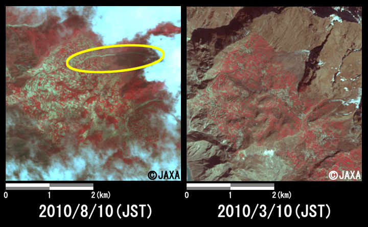
Fig.3: Enlarged images of the mudslides at Meishuishan
(16 square kilometers, left: August 10, 2010; right: March 10, 2010).
(Click to View Enlarged Image)
JAXA plans continuous observation of this area.
The acquired images were provided to China Meteorological Administration via "The International Charter" and China Earthquake Administration via "Sentinel Asia".
* Advanced Visible and Near Infrared Radiometer type 2 (AVNIR-2):
AVNIR-2 is a visible and near infrared radiometer for observing land and coastal zones.
It provides 10-m spatial-resolution image and 70-km swath on the ground. The pointing angle of AVNIR-2 is +44 and - 44 degrees. This image was acquired by 31.0 degrees east.
©JAXA EORC
Copyright©1997- JAXA EORC All rights reserved.