On March 11, 2011 (UTC), a magnitude 9.0 huge earthquake occurred off the Pacific coast of Tohoku-Kanto district in Japan (38.32°N, 142.37°E, 32 km in depth; Hypocenter information from USGS Web site), accompanied by a massive tsunami. The earthquake and tsunami caused severe damage in many cities, and more than 10 thousand people were killed and lost their homes.
The Japan Aerospace Exploration Agency (JAXA) conducted an analysis of the TerraSAR-X satellite data provided by the German Aerospace Center (DLR). TerraSAR-X is a German earth observation satellite that has been developed by DLR and EADS Astrium GmbH. It carries the X-band synthetic aperture radar observing the earth with different wavelength from the Phased Array type L-band Synthetic Aperture Radar (PALSAR) equipped on the Advanced Land Observing Satellite (ALOS).
This time's data provision from DLR was realized since DLR and JAXA have been cooperating under a bilateral MOU in the field of satellite-based disaster monitoring and both are also members of the International Charter Space and Major Disasters. We greatly appreciate such contribution of DLR and support from all persons concerned in Germany.
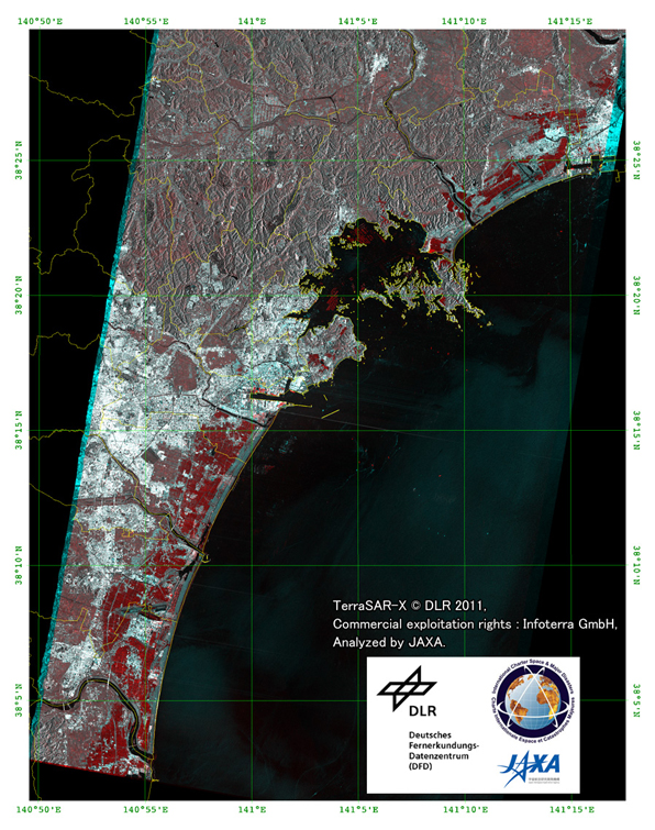
Fig.1: Color composite of TerraSAR-X images around Sendai city
acquired before (red: 2010/10/21) and after (green and blue: 2011/03/12) the earthquake.
(Click to View Enlarged Image)
Figure 1 is a color composite of TerraSAR-X images around Sendai city. Color assignments are red for before the quake and green/blue for after the quake so that the red color represents the flooded area affected by the tsunamis.
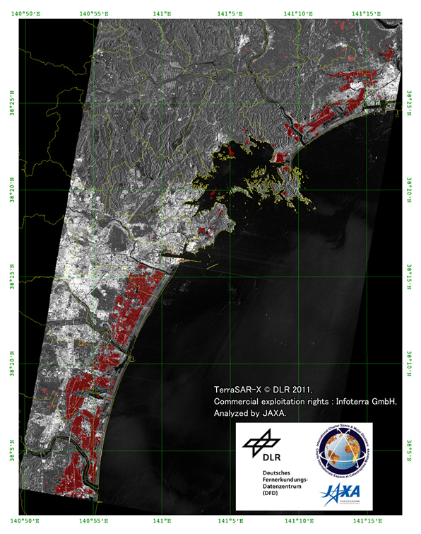
Fig.2: Change analysis map derived from TerraSAR-X images of the after and before the earthquake.
(Click to View Enlarged Image)
Figure 2 is a change analysis map automatically derived from the after and before images same as Figure 1. The red polygon is changed area of radar backscatter between after and before the earthquake. It may represent inundated area, collapsed objects, drifting objects or other affected area by the quakes and tsunamis. Background image is the post-disaster image acquired on 2011/03/12.
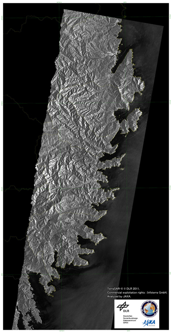
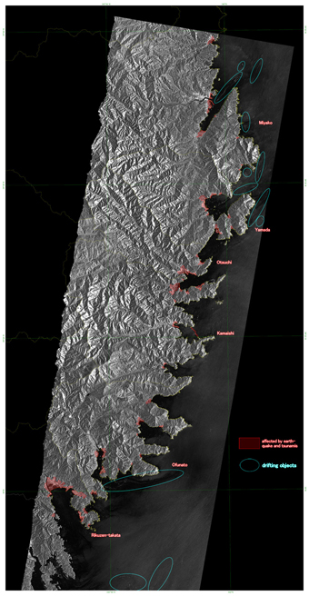
Fig.3: TerraSAR-X post-disaster image around southern Iwate prefecture (2011/03/12).
Left: Original TerraSAR-X image, Right: Interpretation of the image.
(Click to View Enlarged Image)
Figure 3 is the TerraSAR-X image around the southern part of Iwate prefecture. The left figure is the original image acquired on 2011/03/12. The right figure depicts affected areas derived by manual interpretation of the original image. Inundated and collapsed areas are colored in red. Drifting objects on the sea are enclosed by blue circle.
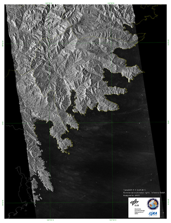
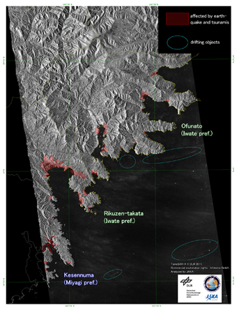
Fig.4: TerraSAR-X post-disaster image around southern Iwate prefecture (2011/03/13).
Left: Original TerraSAR-X image, Right: Interpretation of the image.
(Click to View Enlarged Image)
Figure 4 is the TerraSAR-X image and an interpretation around the southern part of Iwate prefecture of the next day. Drifting objects on the sea spread further offshore.
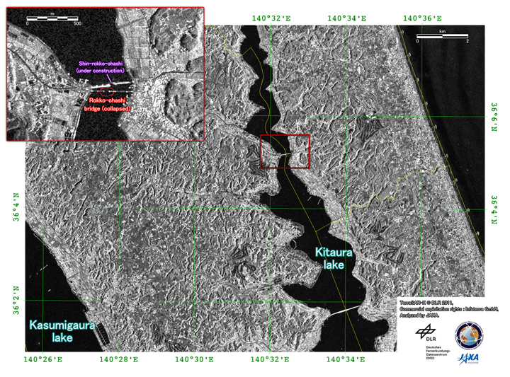
Fig.5: TerraSAR-X post-disaster image around Namegata city, Ibaraki prefecture (2011/03/12).
(Click to View Enlarged Image)
Figure 5 is the TerraSAR-X image around the Rokko-ohashi bridge of Namegata and Hokota city, Ibaraki prefecture. The close-up image, shown on the left-top side, indicates collapse of the bridge.
JAXA plans to continue ALOS observations of the afflicted area.
[Reference]
2011/3/25: Emergency Observation of Magnitude-9.0 Earthquake off the Pacific coast of Tohoku-Kanto District in Japan in 2011 by AVNIR-2 onboard "Daichi" (ALOS).
2011/3/18: ALOS/PALSAR Observation Results of the Magnitude-9.0 Earthquake off the Pacific coast of Tohoku-Kanto District in Japan in 2011.
©JAXA EORC
Copyright©1997- JAXA EORC