Mekong River Commission (MRC) -201412
< Last Update: Jan. 15, 2016 >
SAFE Prototyping Status: December 2014 - <On-going>
Deploying GSMaP for Decision Support in Transboundary Catchments in the Lower Mekong Basin
Mekong River Commission (MRC)
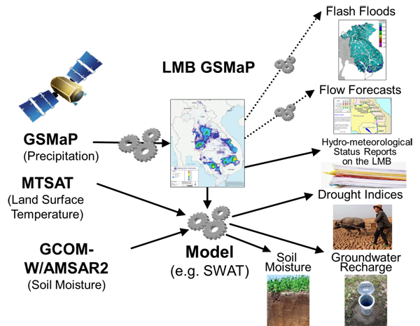
Reliable and sound information on precipitation forms an important basis for real-time flood forecasting, planning and public awareness building within the Lower Mekong Basin. This leads to i) effectively managing flood risks with the aid of short and medium term flood forecasting services, ii) spatial distributions of soil moisture and groundwater recharge, in the absence of data e.g. from ground sensor measurements, can be derived by a continuous application of mathematical models, and iii) Up-to-date soil moisture information can help farmers and irrigation companies to optimize water use and cropping cycles. The purposes of this prototyping are;
1) Deploy GSMaP as a means for quantitative precipitation determination in gauging scarce catchments in the Lower Mekong Basin (LMB)
2) Use GSMaP as a basis to determine soil moisture and groundwater recharge with the SWAT model (Soil and Water Assessment Tool), verify derived data with other elaborate model results based on remote sensing data
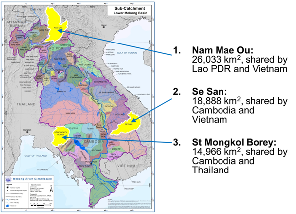
3) Apply and validate the derived methodologies in three different cross-border sub-catchments of the LMB which are subject to different characteristics, e.g. lowlands, mountainous areas and lee sides of mountain ranges affected by tropical cyclones.
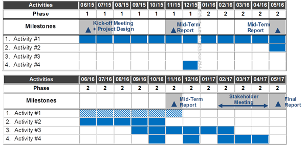
Work Plan
- Activity # 1: Improve the correlation of precipitation derived from GSMaP and gauged precipitation measurements (correlation of daily and monthly precipitation)
- Activity # 2: Develop procedures to determine soil moisture and surface temperatures from remote sensing data and compare with modeling results from SWAT
- Activity # 3: Apply the developed procedures to selected transboundary catchments according to data availability and agreed to by MRC Member Countries
- Activity # 4: Capacity building, consultation meetings and dissemination of prototype results to Member Countries and Dialogue Partners
Developed System / Application
Current Achievement
Kick-off Meeting for the project was conducted on 16 September 2015 at MRCS-OSP. Data sharing is being undertaken
Expected Operational Usage
1) Improved GSMaP in terms of spatial accuracy of predicted / interpolated precipitation fields which can also be used in flow forecasting activities of MRC
2) Determination of spatial distribution of drought indices which can assist in agricultural decision making
3) Determination of spatial distribution of soil moisture and groundwater recharge on reliable and evidence based approaches which again can assist in agricultural decision making
Formation
1) Prototyping Executor
- Ms. Kritsana Kityuttachai
- Mr. Sou Virak
Mekong River Commission (MRC)
2) Technical Supporter
- International Centre for Water Hazard and Risk Management (ICHARM)
- Foundation of River & basin Integrated Communications (FRICS), Japan
3) Data & Application Provider
a) Satellite Data
- Global Satellite Mapping of Precipitation (GSMaP): JAXA
- Advanced Microwave Scanning Radiometer 2 (AMSR2): JAXA
b) Field Data
- Rainfall (with Rain Gauge), River Discharge (Water Level, Rating Curve), Meteorological data (Air Temperature, Soil Temperature, Solar Radiation, and so on)