Satellite Data Processing for Land Cover Mapping
< Last Update: 28 Nov. 2012 >
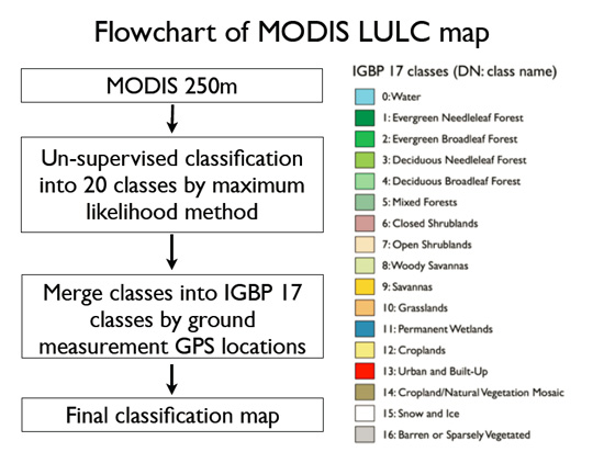
Satellite remote sensing is very useful for periodical monitoring, wide area monitoring, and multi-spectral observation of the earth surface. The remote sensing data is classified into many types of categories (in other words converted into scientific quality data product) and used for practical use. IGBP is the one of the definition to classify the LCLU (Land-Cover and Land-Use) by International Geosphere-Biosphere Program and is Global Land cover product based on 1km AVHRR data. By using the following processing guidance to apply MODIS 250m data to IGBP 17 classes by ground measurement GPS locations, 250m LCMAP is generated
Contact
If you have interest in the application, please contact to the following:
Software required for LCMAP
The softwares can work on Linux, Mac and Windows. The following types of software are required (please install them with guidance described in the next section);
- Cygwin
- a collection of tools which provide a Linux look and feel environment for Windows
- a DLL (cygwin1.dll) which acts as a Linux API layer providing substantial Linux API functionality
- GRASS GIS
- a free Geographic Information System (GIS) used for geospatial data management and analysis, image processing, graphics/maps productions, spatial modeling, and visualization
- an official project of the Open Source Geospatial Foundation
- LCMAP
- a software for land cover mapping developed by Sawada & Takeuchi Laboratory, IIS, the University of Tokyo
Satellite Data Processing Method
-
Software Installation
- Step 1: Cygwin Setup
-
Step 2:
Utilities packages installation
(bc, file, nedit, fvwm, netpbm, unzip, util-linux, wget) -
Step 3:
GRASS GIS and utilities packages for LCMAP installation
(grass, gcc, libgeo, zlib, csh, scsh, libproj, make, makeself, ncurses, vim, graphicsMagick, ImageMagick, gd, rxvt, xterm, ted) - Step 4: gdal and tcltk installation
- LCMAP Generation
- QGIS Software Installation and LCMAP LUT update
Result of the Final Output
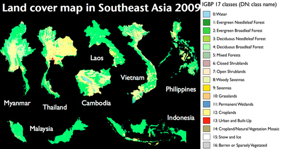
2001 to 2011 (Takeuchi, W. 2011) using the IGBP 17 classes (Belward, A. S., 1996)
Acknowledgement
This tool was developed by grace of Dr. Wataru Takeutchi, Dr. An and Dr. Oo in Institute of Industrial Science (IIS), the University of Tokyo.