Field Survey Software for Forest management
< Last Update: 28 Nov. 2012 >
Field Survey by using free software
(Developed by Institute of Industrial Science, the University of Tokyo)
Background
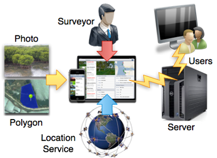
The field survey data is very important to generate and verify the maps, and the databases play a critical role in land cover applications. A basic field survey database for land cover applications includes time, latitude, longitude, and a description of the object of monitoring or mapping, such as the soil temperature, the main species of plant, or the type of irrigated area. To build such a field survey database, a user must carry out field studies with necessary devices (such as a GPS device and camera), enter the data collected into a computer, and convert it to a database. To build a field survey database for land cover applications as well as to provide a tool to conduct field studies, the software package running on Apple's iPhone and iPad, which allows the user to use Apple's iPhone or iPad as a tool to collect field survey data including photos, locations, and user-defined data, was developed by Institute of Industrial Science (IIS), the University of Tokyo. The application is very useful and efficient tool to record data of field survey (You don't have to carry a lot of devices such as GPS device, camera, maps anymore) and to manage the output for the research. You can integrate field data including photo, its location and polygon into one user map and distribute the information through the server to the users.
Expected Use and Purpose
This software package can be used for many kinds of field survey, in which the user collects the information such as photo, polygon, latitude, longitude, and other information in text format. The user can define which information he will collect.
Case Study / Example
The IIS, the University of Tokyo used this software in our field trips in Vietnam and Laos to collect the data for GPS Photo Database, which we used for the SAFE prototypes in Vietnam and Laos. For example, in a field trip to the mangrove forest in Quang Ninh province of Vietnam, we used the software on iPad to collect the information for our GPS Photo Database: photo, polygon, latitude, longitude, altitude, main species of plant, the average height of tree, the diameter of tree, number of trees in a plot, soil temperature, humidity and so on. There are nearly 6,000 information items in our GPS Photo Database, which were collected since 2008 in Vietnam, Laos and Myanmar.
Contact
If you have interest in the application, please contact to the following:
Guide on how to use the software
"GPS Photo" (Software on iPhone)
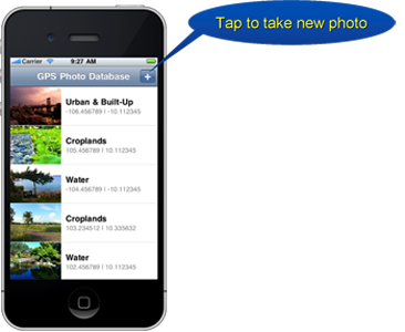
1. Taking photos
- User needs to take a photo of the field
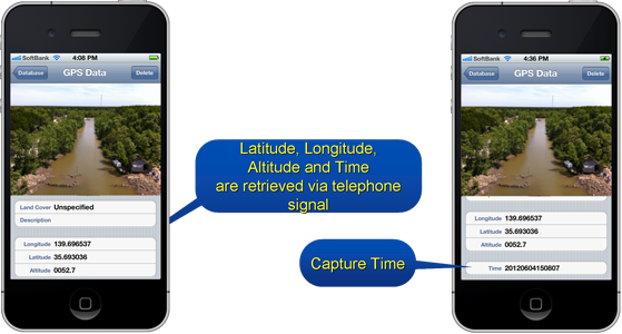
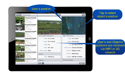
2. Retrieving latitude, longitude and time
- Latitude, Longitude, Altitude and Time are retrieved automatically
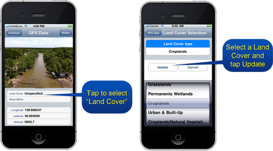
3. Selecting Land Cover type
- User can select "Land Cover Type"
4. Making Description
- User can edit "Description" of the field
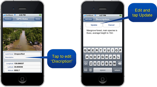
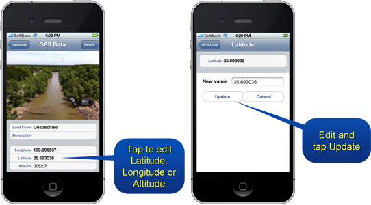
5. Editing Latitude, Longitude or Altitude
- User can edit Latitude, Longitude or Altitude
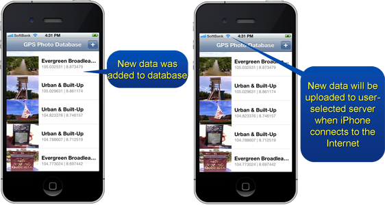
6. Uploading data to server
- User can upload data to the server
"Field Survey" (Software on iPad)
1. Taking photos & video
- User needs to take a photo of the field
2. Retrieving latitude, longitude, altitude
- Latitude, Longitude, Altitude and Time are retrieved automatically
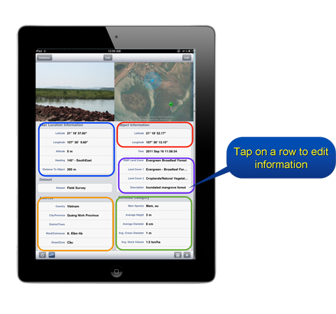
3. Defining Land Cover description and Editing user-defined data
- User can select "Land Cover Type" and edit "Description" of the field
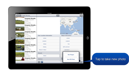
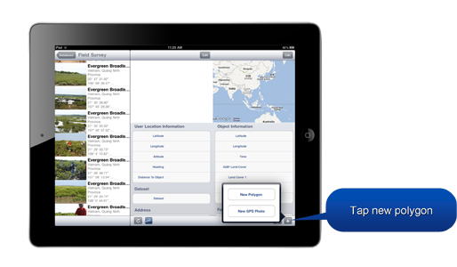
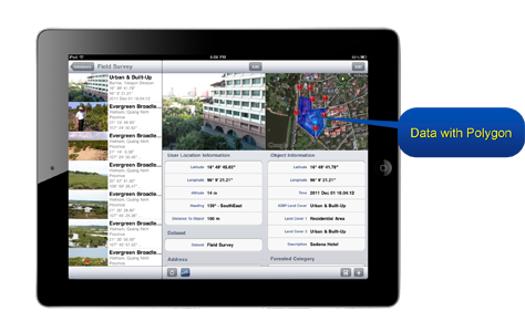
4. Creating new polygon
- User can create new polygon
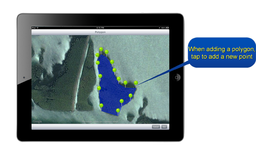
when you visit a large region, in which all objects (for example, all trees) are same, you do not need to visit many places and take many photos, you need to visit only one place, take one photo, and specify one polygon for that region. It means that all the points inside that polygon have the same information as the place you visited and took photo.
5. Adding new polygon
- User can add new polygon which have the same information
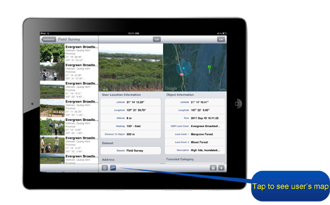
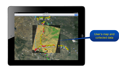
6.Checking the user's map
- User can check the user's map you created
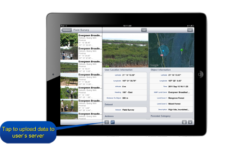
7.Uploading data to server
- User can upload data to the server
Acknowledgement
This tool was developed by grace of Dr. Wataru Takeutchi, Dr. An and Dr. Oo in Institute of Industrial Science (IIS), the University of Tokyo.