Myanmar (MOALI) -201512
< Last Update: Oct. 21, 2016 >
SAFE Prototyping Status: December 2015 - <On-going>
Promote a Department of Agricultural Land Management and Statistics (DALMS) system through using Innovative rice crop area mapping and yield monitoring with space based technologies
Department of Agricultural Land Management and Statistics (DALMS),
Ministry of Agriculture, Livestock and Irrigation (MOALI)
The current paddy-area and yield related information are collected through typical data collection method in Myanmar involving local level staff and this procedure could subject to various human errors. Therefore, it is becoming necessary to develop a system minimizing possible errors but in the meantime accelerate the efficiency of accurate data collection. This prototype is to develop a new information collecting method that will be cost-effective and complementary to present rice crop area and production estimation to support statistical information generation.
The purpose of this prototype is to develop a cost effective, efficient, accurate and timely observation method using space based technologies to identify
1) Knowledge information of land management through capacity building of SAR utilization
2) Provide rice growing stages and rice area estimation information and production to DALMS's land management system using space technology
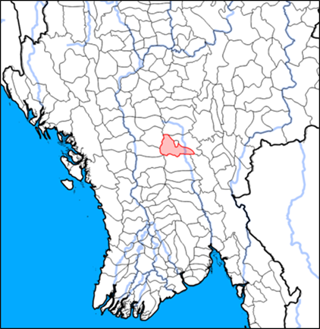
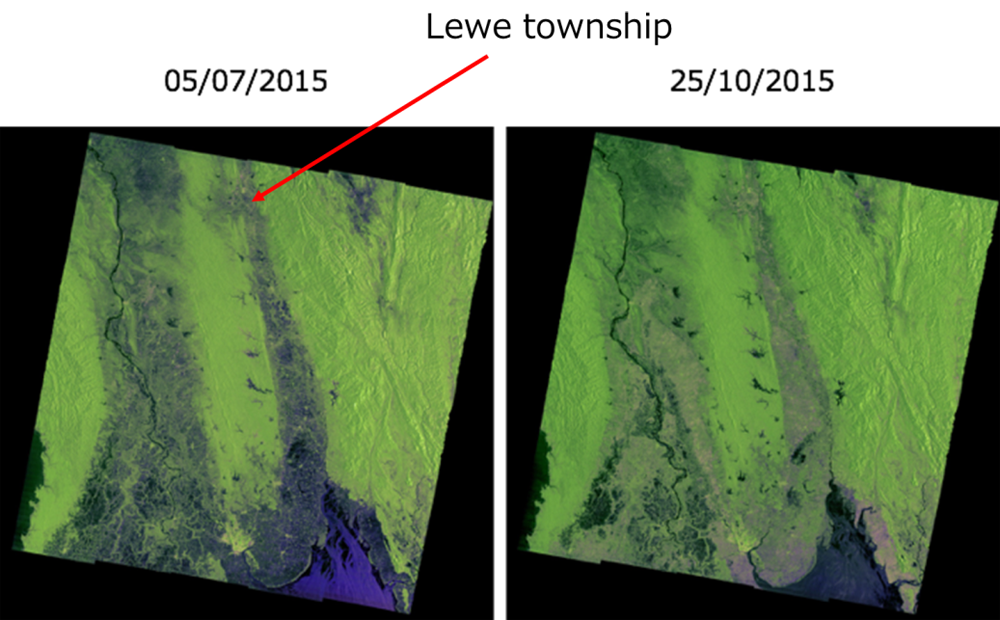
Study Area
Lewe township, part of Nay Pyi Taw at the middle of Myanmar
- Semi-Arid Region
- Hilly on the West
- Plain at the middle and on the East
- 14 small dams/ reservoirs
- 6 embankments for flood protection
Work Plan
Activity 1:
ALOS-2 and INAHOR training for DALMS staff and/or necessary experts in other related organizations under MOALI as trainers on the use of space based technologies, especially for SAR application. (1st year)
Activity 2:
Select training area for field survey. And conduct a field survey. (1st year)
Activity 3:
Generate rice planted area map using INAHOR and compare it with field survey data. (1st year)
Activity 4:
Identify differences between DALMS official statistics and the result of the prototype and study the ways to incorporate both results to improve statistical data of DALMS. (1st -2nd Year)
Activity 5:
Conducting field survey and mapping by INAHOR with updated method based on activity 4. (2nd Year)
Activity 6:
Hold Stakeholder meeting. (2nd Year)
Developed System / Application
Empirical model method to estimate yield

Expected Operational Usage
1) Innovative rice crop area mapping, rice growing stage and yield monitoring using space based technologies and use those deliverable as a complementary information of statistical information of rice crop area and production estimation
2) Develop capacity building of SAR data application for agriculture area in MOALI
3) Have a knowledge to apply SAR data to estimate flood area
Formation
1) Prototyping Executor
Agricultural Land Management and Statistics (DALMS), Ministry of Agriculture, Livestock and Irrigation (MOALI) of Myanmar
2) Technical Supporter
- Remote Sensing Technology Center of Japan (RESTEC)
3) Data & Application Provider
a) Satellite Data
- ALOS (2007-2011) and ALOS-2 (2016-) : JAXA
- Sentinel: ESA
b) Tools
- INAHOR software developed by JAXA