Cambodia (MAFF) -201512
< Last Update: Oct. 21, 2016 >
SAFE Prototyping Status: December 2015 - <On-going>
Promote rice planted area and production estimation using space based technologies
Department of Planning and Statistics, Ministry of Agriculture, Forestry and Fishery (MAFF)
The current paddy-area and yield related information are collected through typical data collection method involving local level in Cambodia, necessary to develop a system minimizing possible errors accurate data collection.
To develop a new information collecting method that will be cost-effective and complementary to present rice crop area and production estimation to support statistical information generation.
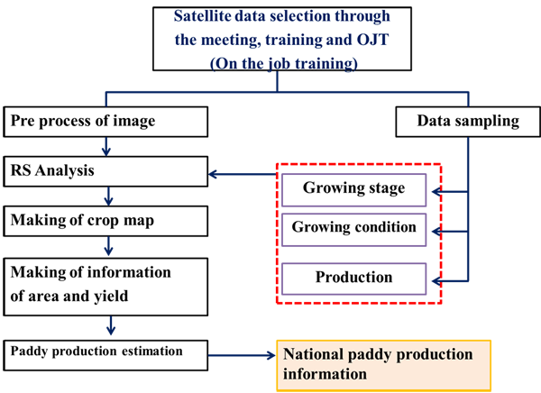
The objective of this prototyping is to develop a cost effective, efficient, accurate and timely observation method using space based technologies to identify
1) Knowledge information of land management through capacity building of SAR utilization.
2) Provide rice growing stages and rice area estimation information and production to MAFF, Cambodia using space technology.
Study Area
Battambang Province (North Area)
Work Plan
(December 2015 ~ November 2017)
- Hold kick off meeting and OJT for INAHOR (SAR data analysis software tool) and SAR training
- Rice crop area estimation using JAXA's INAHOR with archived ALOS ScanSAR data and other SAR
- Mid-Term Report#1
- Rice crop area estimation using ALOS-2 ScanSAR data and other SAR in rice crop season 2016 with ground observation
- Mid-Term Report#2
- Tune up parameter to estimate Rice crop area and production using statistical information
- Mid-Term Report#3
- Hold stake holder meeting
- Final Report (24th Month): Completion of the Prototype.
Developed System / Application
Expected Operational Usage
1) Promote to strengthen existing system in MAFF, Cambodia through the following activities
- Create maps on land use/land cover as baseline information for environmentally sustainable agriculture land management
- Develop a standardized, accurate, cost efficient and timely method to monitor rice crop area, rice growing stages and rice yield to augment national agriculture statistic information.
2) Develop capacity building of SAR data application for agriculture area in MAFF, Cambodia.
3) Have a knowledge to apply SAR data to estimate flood area
Formation
1) Prototyping Executor
- Ms. Meas Sotheavy
Department of Planning and Statistics (DPS), MAFF
2) Technical Supporter
- Remote Sensing Technology Center of Japan (RESTEC)
- Geo Informatics Center (GIC) / Asian Institute of Technology (AIT)
3) Data & Application Provider
a) Satellite Data
- ALOS (2007-2011) and ALOS-2 (2016-) : JAXA
- Sentinel: ESA
b) Tools
- INAHOR software developed by JAXA