 Public Health
It is concerning that environmental changes including temperature or precipitation changes accompanied by global warming can cause health hazards directly (heatstroke, circulatory disease or respiratory illness, etc.) or indirectly (malaria, cholera, polio, dengue or other infectious diseases). Such disease outbreaks cannot be predicted at an early stage and preventive measures cannot be taken, which is one reason why they can cause extensive damage. It has been pointed out that environmental changes associated with precipitation, temperature and topography are connected to the occurrence of health hazards. However, in developing countries, the surveillance system for such environmental information is inadequate. EORC makes a great effort to advance research and development for early warning systems for infectious diseases using satellites' earth observations. This is in cooperation with research institutes including universities and international organizations.
Development of the JAXA's Public-health Monitor and Analysis Platform (JPMAP)
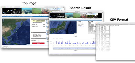
Online Environmental information provision system
EORC developed a user-friendly web-based system, JAXA's (Japan Aerospace Exploration Agency) Public-health Monitor and Analysis Platform (JPMAP), which distributes satellite-derived environmental information, such as rainfall, shortwave radiation, soil moisture, normalized difference vegetation index (NDVI), aerosol optical thickness (AOT), land surface temperature (LST), and altitude. The system was designed for users to download the data and utilize it without any additional data processing. Users can request data with a specific geographic location and time interactively via the website and then use the data for epidemiological analyses. EORC conducts research on the utilization of these satellite-derived environmental information for the mitigation of infectious diseases such as malaria or dengue fever through proactive prevention measures based on the result of epidemic risk analysis in collaboration with related agencies.
Effective Use of Digital Elevation Models to Monitor the Spread of Poliovirus

Water Catchment Area Estimation Results collected effectively using the ALOS Digital Elevation Model
For WHO (World Health Organization), it is an urgent task to construct a viral infection situation data acquisition system, with periodical sampling of sewage water. For this purpose, it is important to identify efficient sampling points considering sewage water flow. In Nigeria, EORC has demonstrated that the water catchment areas can be identified (purple areas) and the selection of sewage water sampling points (red cross points) can be refined, by water analysis using the ALOS PRISM digital elevation model (AW3D), in cooperation with WHO.
Surveillance of Lake Victoria for Early Warning of Cholera
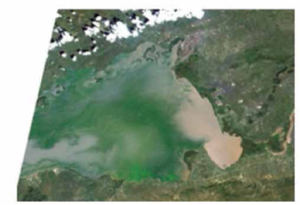
Lake Victoria’s Surface Image from ALOS AVNIR-2
It has been pointed out that water hyacinth growing on Lake Victoria could possibility transmit cholera germs. Therefore, it is highly anticipated that the expansion of the water hyacinth growing area can be estimated based on the satellite data obtained by the AVNIR-2 sensor etc., aboard the Advanced Land Observation Satellite "DAICHI" (ALOS). EORC performs the research jointly with the Research Institute of Tropical Medicine, Nagasaki University. Together they estimate the relationship between the water hyacinth growing area and epidemiological data such as the number of cholera patients based on satellite data.


