Earth Observation Priority Research
Assembling observation data in earth observation priority research and promoting new research by combining it with models to contribute to the prosperity of humanity.
In EORC, we do "Earth Observation Priority Research" where analysis and research are developed multi-dimensionally in cooperation with universities, research institutes and foreign researchers. The data is then sent from earth observation satellites in an integrated way. We aim to address issues in various fields including the oceans, the water cycle and water resources, the atmosphere, infrastructure monitoring, radioactive processes, ecosystems, agriculture and public health, etc.
Collecting Earth Environment Data from Space using Earth Observation Satellites
Our daily lives are endangered by changes in earth environment caused by human activities such as deforestation (tropical rain forests in particular), destruction of the ozone layer and global warming, and natural phenomena such as earthquakes, volcanic eruptions and climate change, etc.
EORC calibrates and validates the earth environment data essential for our daily lives, including the oceans, the water cycle, the atmosphere, climate change, infrastructure and health, etc., for each earth observation satellite and project, and develops algorithms for the effective use of observation data. Moreover, we produce useful data output so that we can forecast the changes in earth environment and cope with disasters or climate change quickly by combining the data sets sent from two or more satellites and applying the cross-project data to earth environment modeling.
Themes and Satellites to be used for Earth Observation Priority Research
![]()
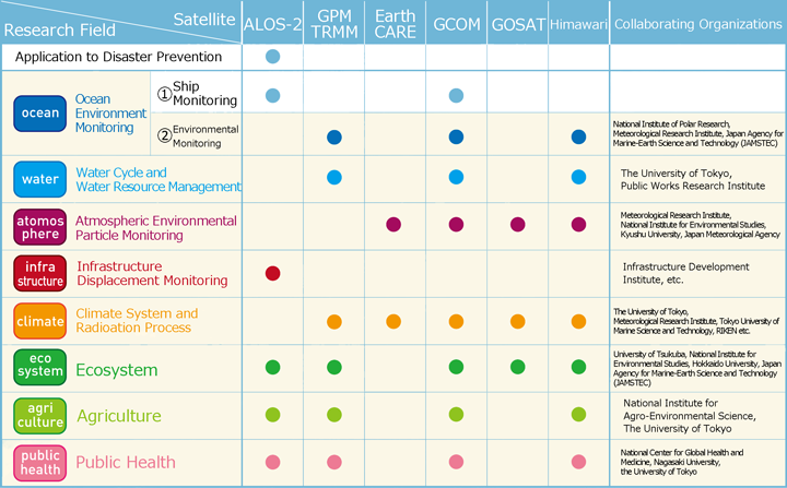
ALOS-2: Advanced Land Observing Satellite "DAICHI 2", GPM: Global Precipitation Measurement, TRMM: Tropical Rainfall Measuring Mission, EarthCARE: Earth, Clouds, Aerosols and Radiation Explorer Mission, GCOM: Global Change Observation Mission, GOSAT: Greenhouse Gases Observation Satellite "IBUKI", "Himawari": Geostationary Meteorological Satellite
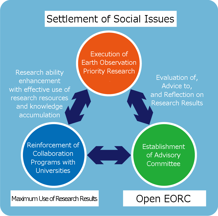
Open EORC and Maximizing the Availability of Research Results
EORC intends to use human resources effectively including those in universities and research institutes and other foreign researchers. This is to develop an increase in the number of users and strengthen collaboration. This is a change from what was previously JAXAs stand-alone approach. The work now is to establish an all-Japan system and maximize the use of research results, as well as to reinforce the EORC's research function by promoting Earth Observation Priority Research.
Also, to create a more open and transparent EORC, the EORC advisory commission has been established to promote evaluation and dispatch of the research results.
International Collaboration Obtaining data on the changes in earth environments multi-dimensionally, in collaboration with various organizations
The most important issue related to environments that we face now is the global scale of problems, and we need to think of it not for single country, but from the international point of view. For example, GPM (Global Precipitation Measurement) is an international collaborative mission where high accuracy and high frequency global precipitation observations are made to elucidate climate change and water cycle change. It utilizes a main satellite (GPM/DPR: Global Precipitation Measurement/Dual-frequency Precipitation Radar) and the Constellation Satellites. Japan, the US, France and India participate in this project.
For everyday weather forecasts, the observation data from GCOM-W (Global Change Observation Mission) "SHIZUKU" using the microwave radiation scale is used for high-accuracy rainfall prediction by as many as 264 meteorology organizations in 36 countries including the Japan Meteorological Agency.
Accumulated greenhouse gas emissions due to land use changes (deforestation) account for 25% of the total accumulations of gas from 1750 to 2010. The increase of such greenhouse effect gases is a significant factor for climate change. Forest preservation is recognized as an important project and countermeasure against climate change. Because of this, JAXA is going to start a tropical forest-monitoring program with satellites in cooperation with JICA (Japan International Cooperation Agency). This project is to contribute to effective countermeasures against climate change, to deter deforestation, prevent natural disasters, and also for biodiversity conservation. This project is expected to help limit deforestation in countries where the problem is serious due to illegal logging in the short term, and to overall forest preservation by the United Nations in the long term. EORC continues to challenge itself to find solutions to problems on the earth and the whole of humanity not only for the present, but also for the future.
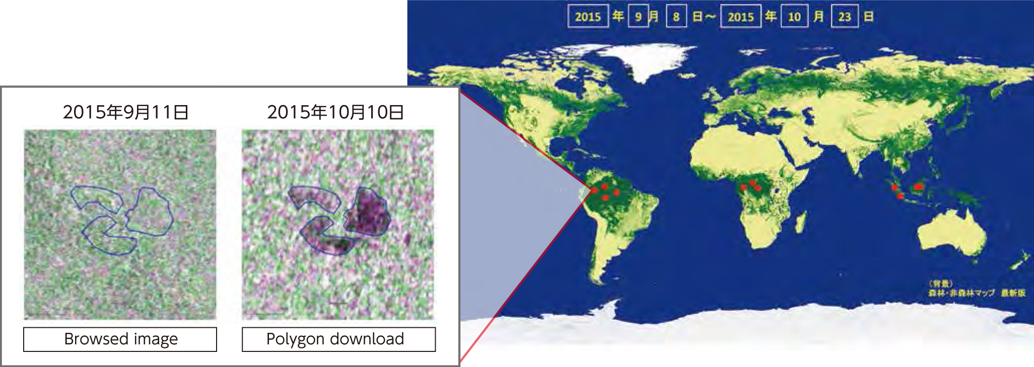
EORC's Attempt to Restrict Illegal Logging and Global Warming with the Forest Change Detection System in collaboration with JICA
EORC cooperated with JICA to identify the illegal logging areas in the Amazon based on observation data from the Advanced Land Observation Satellite (ALOS) "DAICHI" from 2009 to 2012. In April 2014, JAXA and JICA concluded the cooperation agreement for the purpose of finding solutions to global issues particularly in developing areas of the world, using their aerospace technology. In COP 21 held in Paris in December 2015, they jointly announced the "Forest Governance Improvement Initiative". According to its framework, the "Forest Change Detection System" will be built using the "Advanced Land Observing Satellite "DAICHI 2" (ALOS-2) effectively.


