SAFE Workshop AGENDA - Dec. 1, 2014
< Last Update: Dec. 17, 2014 >
CONFERENCE ROOM 1 REMOTE SENSING TECHNOLOGY CENTER OF Japan (RESTEC)
![]()
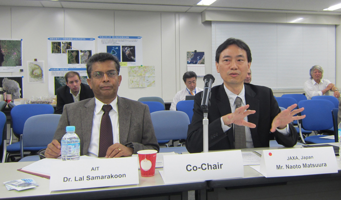
Co-Chair:
Dr. Lal Samarakoon, Director of Geoinformatics Center, Asian Institute of Technology (AIT)
Mr. Naoto Matsuura, Director, Earth Observation Research Center (EORC), Japan Aerospace Exploration Agency (JAXA)
Day0: Dec 2 SAFE workshop
| Time | Agenda Item(s) |
|---|---|
| 9:00 | Registration Open | 9:00-9:30 | Pre-Review Board Meeting (Conference room 2) - Self introduction - Explaining situation of applications (SAFE secretariat, 5min) - Sharing review point for each new proposals, etc. |
| 9:30-18:00 SAFE Workshop | |
| 9:30-10:00 (5min) |
Opening session |
| (10min) (5min) 9:50-10:00 |
- Introductions by all participants (Mr. Ko Hamamoto, SAFE secretariat, EORC, JAXA) |
| 10:00-11:30 |
Proposal of new prototyping |
| 10:00-10:30 |
Utilization of Remote Sensing Satellite Data for Monitoring Quality Change of Lake Ecosystem in Indonesia (Dr. Bambang Trisakti, LAPAN, Indonesia) |
| 10:30-11:00 |
Land Use Changes of "Trees Outside Forests" Sources in Upper Mahaweli Catchment in Sri Lanka: Using Agent Based Moadeling (Mrs. H.M.B.S Hearath, University of Sri Jayewardhenapura, Sri Lanka) |
| 11:00-11:30 |
Deploying GSMaP for Decision Support in Transboundary Catchments in the Lower Mekong Basin (Dr. Michael Haase, IKMP, MRC) |
| 11:30-12:50 | Lunch Break Group photo |
| 12:50-14:30 |
Progress Report of On-going prototyping |
| 12:50-13:10 |
Rice Crop Monitoring in the Mekong Delta, Vietnam (Dr. Lam Dao Nguyen, VNSC, VAST, Vietnam) |
| 13:10-13:30 |
SAR Technology Application for Paddy Crop Monitoring in Central Area of Paddy Production, in Indonesia (Dr. Rizatus Shofiyati, ICALRD, Indonesia) |
| 13:30-13:50 |
Monitoring of Agricultural Land Abandonment Using Remote Sensing (Dr. Farrah Melissa Muharam, UPM, Malaysia) |
| 13:50-14:10 |
Assessment and evaluation of the erosion on the coast around Ma river estuary in Vietnam (Dr. Nguyen Tanh Hung, Deputy Director, KLORCE, VAWR, Vietnam) |
| 14:10-14:30 |
Utilizing satellite data, numerical rainfall forecasts, combining with ground observations in flood forecasting for the Thai Binh river system (Mr. Dang Ngoc Tinh, Division Chief, NHMS/MONRE, NCHMF, Vietnam) |
| 14:30-15:00 | Review Board Meeting (Conference room 2) / Coffee Break |
| 15:00-15:40 |
Introduction of Development Aid Agencies Projects |
| 15:00-15:20 |
JICA's activities in the Asia-Pacific region (Mr. Kenichi Shishido, JICA) |
| 15:20-15:40 |
Asian Development Bank Projects Applying the Result of SAFE Project (Mr. Yusuke Muraki, ADB) |
| 15:40-15:55 |
Follow-up report of completed prototypes (Mr. Masanori Muto, SAFE secretariat) |
| 15:55-16:20 |
Stakeholder meeting report (Mr. Mohammad Rezaul Karim, LGED, Bangladesh) |
| 16:20-16:50 |
Final report of Prototypes expect completion The assessment of Mangrove Forest Carbon Stock Monitoring of Indonesia using Remote Sensing Approach (Dr. Ety Parwati, LAPAN, Indonesia) |
| 16:50-17:10 |
Future collaboration of EO and GNSS - EO and QZSS for Oil Palm Precision Farming Protoyping (Dr. Abdul Rashid Bin Mohamed Shariff, UPM, Malaysia) |
| 17:10-17:30 |
Wrap-up - Summarizing comments and discussion for prototyping
- Report of Review board meeting and decision taken for approval of new proposal |
| 17:30 Adjourn | |


