| |
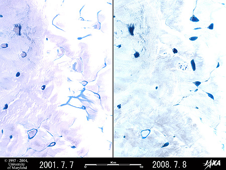 |
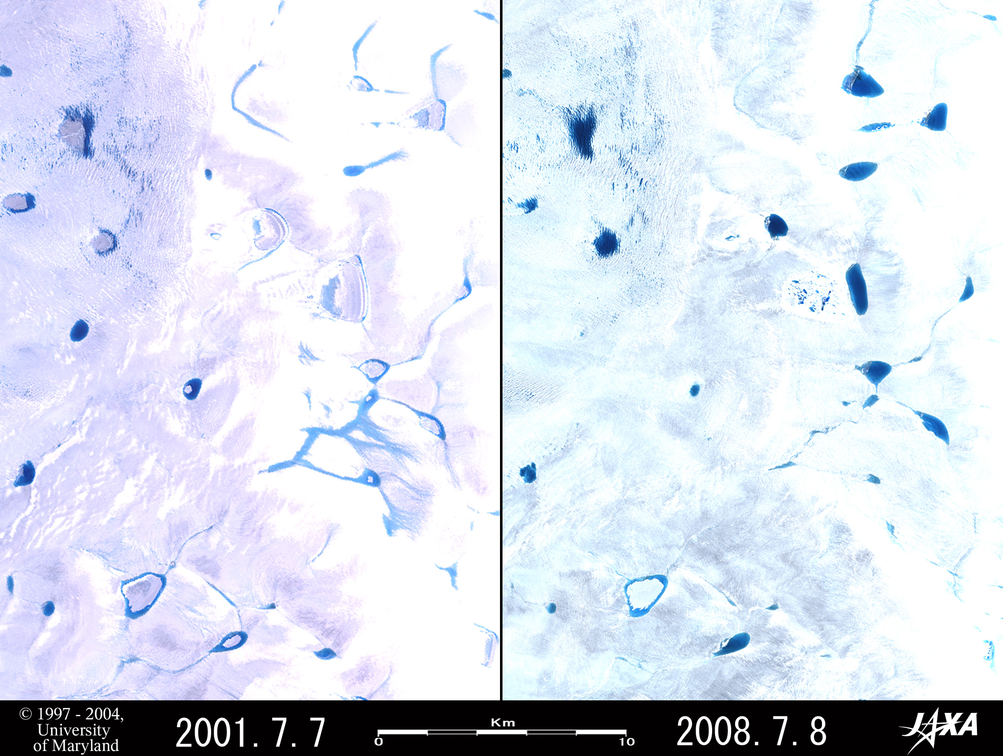
| Fig. 1 Melt Ponds on Ice Sheet in Western Greenland (Part 1) |
Figure 1 covers an area 110km northeast of Ilulissat in western Greenland and depicts many melt ponds, formed by melted snow and ice, on the surface of the ice sheet. The left image was acquired by the USA's Landsat 7 in the summer of 2001, and the right one, by JAXA’s Advanced Land-Observing Satellite "Daichi" in the summer of this year (2008). Comparing the images, you can see that numerous ponds were practically in the same places seven years since the last observation and that the light-blue (that is, shallow) long and narrow ponds in the 2001 image have been replaced by dark blue (that is, deep) ponds in the 2008 image. The centers of some ponds are white, and the surroundings are blue. It seems that the centers are frozen, but the surrounding areas are open water. Ten such ponds can be seen in the 2001 image, but the majority of them had become dark ponds, indicating that the ice sheet in western Greenland has melted further in these seven years. Using the scale bar under the figure, you can see that the long, narrow ponds are up to 100m wide and that the northernmost pond measures 0.9km by 1.7km.
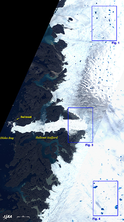 |
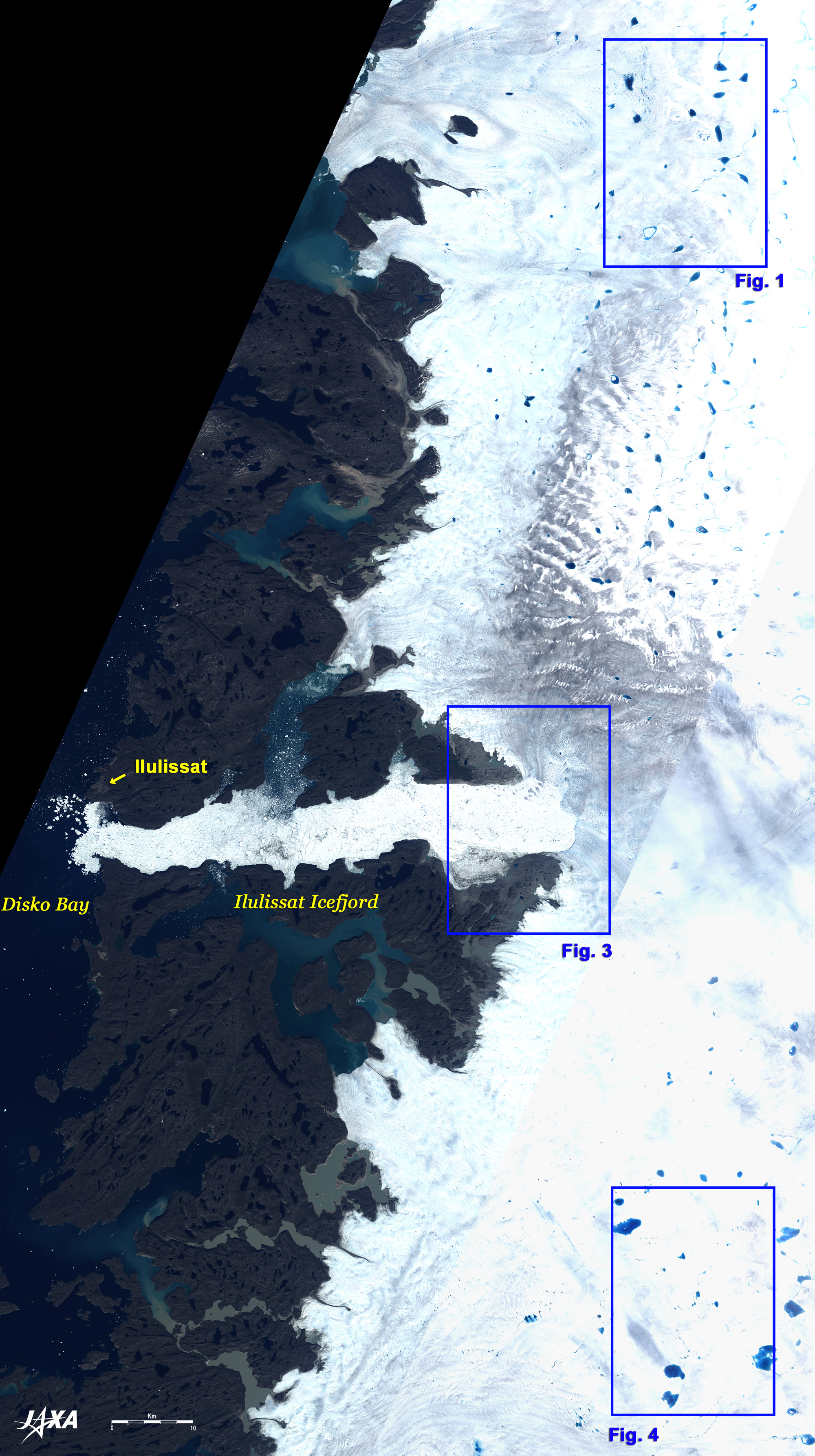
Fig. 2 Wide-Area Image of Western Greenland
Ilulissat, Greenland (kmz, 5.30 MB, Low Resolution) as seen on Google Earth. |
Figure 2 presents a wide-area image of western Greenland as acquired by ALOS (Daichi) in July 2007, and there are ice sheets covering the eastern half of the figure, the Disko Bay in the western end. Between the ice sheets and the bay, areas of exposed rocks and fjords form complicated patterns. In the expanded image, you can see some icebergs on Disko Bay and some fjords (white dots).
In the center of the figure, you can see the Ilulissat Ice fjord, with a maximum length of 60km and a maximum width of 13.6km. The city area of Ilulissat, population 4,000, is visible on the northern coast of the mouth of the fjord, and the 1,000m runway of the Ilulissat Airport is about 3km north of the town. The Ilulissat Icefjord
was added to the World Natural Heritage list of the United Nations Educational, Scientific and Cultural Organization (UNESCO) in 2004 because it is an outstanding example of a stage in the Earth’s history, the last ice age of the Quaternary Period, and the combination of a huge ice sheet and a fast moving glacial ice stream calving into a fjord covered by icebergs is a phenomenon only seen in Greenland and Antarctica.
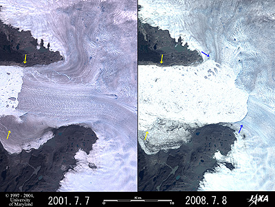 |
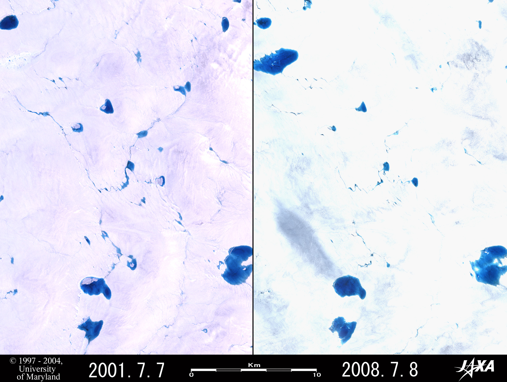
| Fig. 3 Retreat of Jakobshavn Glacier |
Figure 3 illustrates the upper stream of the Ilulissat Icefjord. Comparing the left and right images, you can detect the terminal of the Jakobshavn Glacier (Sermeq Kujalleq in Greenlandic), which pours into the Ilulissat Icefjord, which had retreated 13.6km from the 2001 location (yellow arrow) to The 2008 location(blue arrow) in the last seven years. It thus retreated 1.9km per year on average, corresponding to about nine times the retreat velocity (220m per year) of the terminal of the Upsala Glacier as presented in the article "Huge glaciers retreat on a large scale in Patagonia, South America."
The glacier that had covered Ilulissat Ice fjord has now been replaced by numerous icebergs that were calved from the glacier. For the status in 1994 and 2007, please refer to the IPY dataset homepage within the EORC homepage.
 |
| Fig. 4 Melt Ponds on Ice Sheet in Western Greenland (Part 2) |
Figure 4 depicts an area 100km southeast of Ilulissat and 70km south of the area of Fig. 1. Comparing the left and right images of Fig. 4 reveals that the majority of melt ponds existing in 2001 also exist in 2008, but some of them have shrunk significantly. Additionally, some rivers connecting the melt ponds narrowed during the last seven years. A newly formed 1.6km-by-2.6km pond can be seen in the upper left of the right image. Figure 4 contains larger melt ponds than Fig. 1, suggesting that the ice sheet in Fig. 4 had melted before that in Fig. 1.
Explanation of the Images:
Fig. 2 and left sides of Figs. 1, 3 and 4
AVNIR-2 has four observation bands. These figures were composed by assigning red to visible Band 3 (610 to 690nm), green to visible Band 2 (520 to 600nm), and blue to visible Band 1 (420 to 500nm). The resulting image has natural coloring as if seen by the naked eye. In these images, snow and ice are white or pale gray, exposed rocks are dark brown, and water surfaces are dark-blue or light-blue. Areas with no data are black. Figure 2 was made by mosaicking six images. The ground resolutions of Figs.1, 3 and 4 were reduced to 20m and that of Fig. 2 was reduced to 50m in order to cover a wider area.
Left sides of Figs. 1, 3 and 4
Here, we used data downloaded free of charge from the Global Land Cover Facility (GLCF) Earth Science Data Interface operated by the University of Maryland, USA.
The images were composed by assigning red to visible Band 3 (630 to 690nm), green to visible Band 2 (520 to 600nm), and blue to visible Band 1 (450 to 520nm). The resulting images have natural coloring as if seen by the naked eye. In these images, snow and ice are white or pale purple, exposed rocks are dark brown, and water surfaces are blue or light blue.
|
|