Seen from Space 2004
Greenland: A White Land Storing 250,000 Year Old Ice
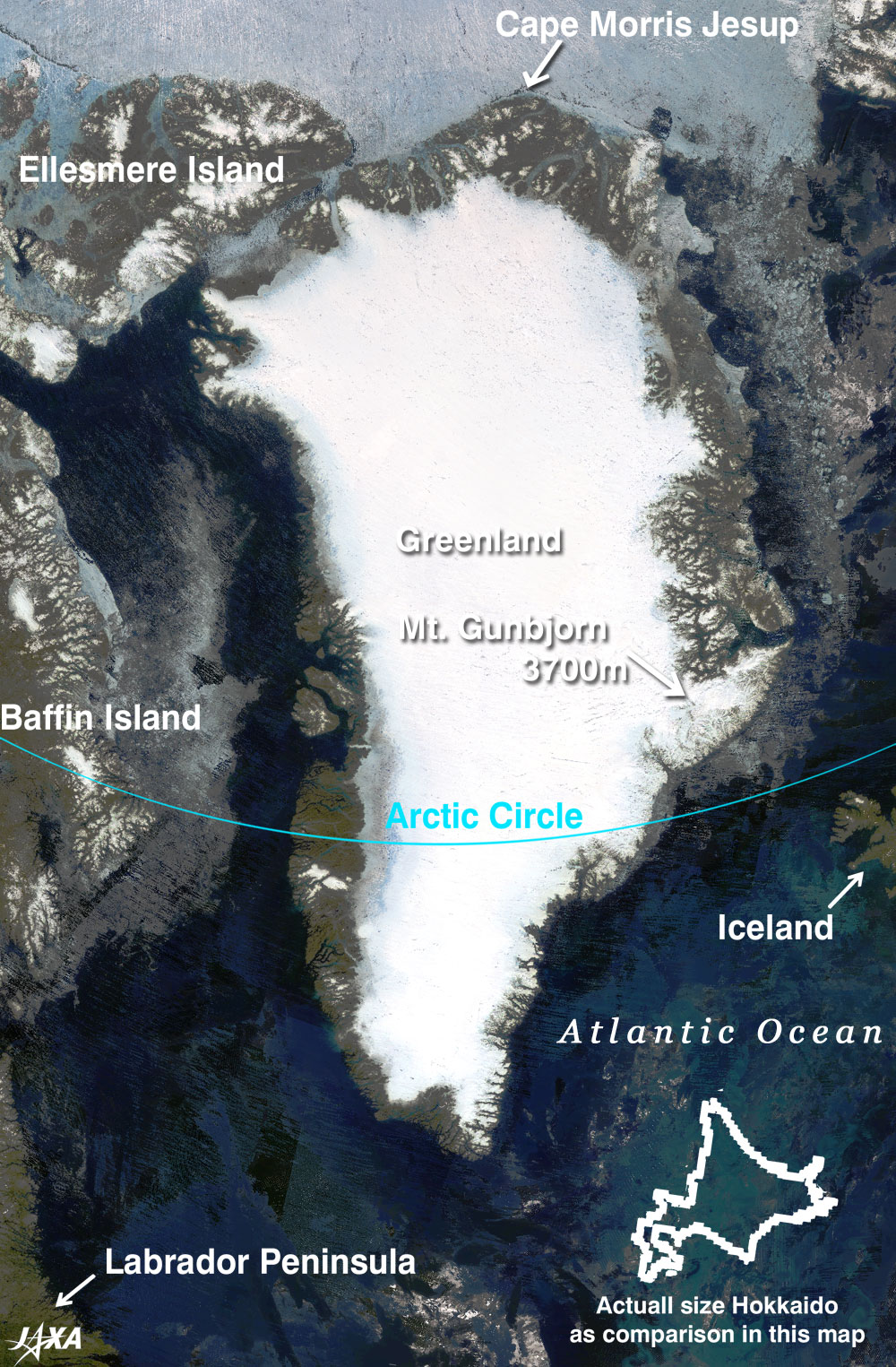
Figure 1 show s all of Greenland in the early summer of last year (2003) . The image indicates that the ground is exposed along the coast of Greenland, but inland appears pure white with a covering of a bulky ice sheet(*1). The narrow western edges of the ice sheet lie in a north-south direction and look grey or translucent. The sea ice also looks grey or translucent. This implies there are many ponds made of meltwater on the surface of the ice. The coastline is very complicated due to so many fjords. The northern coast of Greenland and the Arctic Sea are still covered with snow and ice. This image covers Ellesmere Island in the upper left, Baffin Island on the left, a part of the Labrador Peninsula in the lower left, the Atlantic Ocean in the lower right, and Iceland on the right. The sea area in the lower right of this image appears light blue due to a a bloom of phytoplankton. The white stripe stretching in the east-west direction in Frame A is Ilulissat Glacier. This glacier grows 25 to 30 m per day and supplies many icebergs by pouring into Disco Bay. Some large icebergs are as high as 100 m above sea level. These icebergs drift southward with the Labrador Current to just off Newfoundland Island. Frame B includes the capital Nuuk (*2). At Isukasia, 140 km northeast of Nuuk, geologists found what they believe to be the world's oldest class (3,800 million years old) sedimentary rocks and pillow lava. These rocks show that the sea existed 3,800 million years ago. Frame C includes the first settelement, Narsarsuaq, where the name Greenland originated (cf. Appendix). Cape Morris Jesup in the northern end of Greenland, is the northernmost land point in the world. At lat. 83°39'N, it is 708 km from the North Pole. Greenland, the world's largest island is 2.18 million square km in area about six times the size of Japan. The major part is located within the Arctic Circle, and 85% is covered with ice sheet. The average height of Greenland's Ice Sheet is 2,132 m, with a highest point of 3,231 m. The maximum thickness of the Ice Sheet is 3,411 m, and its base is approximately 300 m below sea level. This implies the crust is becoming hollow due to the weight of the ice. Mt. Gunbjorn (3,700 m above sea level), the highest mountain in Greenland, is near the eastern coastline. The image shows that the mountain range along the coastline dams the huge ice sheet and blocks it to flow out into the sea like the flank of a frying pan. The volume of ice in Greenland is estimated to be 2.85 million cubic km (*3). Ice believed to be 250,000 years old or more is stored at the deepest part of the center of the ice sheet. Should all the ice sheet melt, it is esmtimated that the sea level would rise 7.2 m (*3). (*1) An ice sheet stores ice for thousands to several hundred thousands of years. The ice sheets in Antarctica and Greenland are the largest ones. (*2) Greenland belongs to Denmark, but the Greenland Home Rule act of 1979 permits a wide range of self-government. Nuuk has become the de facto capital. (*3) cf. IPCC ( Intergovernmental Panel on Climate Change ) 2001 report. The report estimates that the Antarctica Ice Sheet currently stores 25.71 million cubic km ice and estimates that if that ice all melts, the sea level could rise 61.1 m. However, the report does not forecast that the ice sheet in Antarctica and Greenland would melt massively before 2100. Instead , it forecasts that the sea level will rise nine to 88 cm in 2100 compared to 1990. Please refer to the following site for more information on the IPCC 2001 report. Related sites:
|
|||||||||||||||