| |
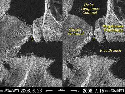 |
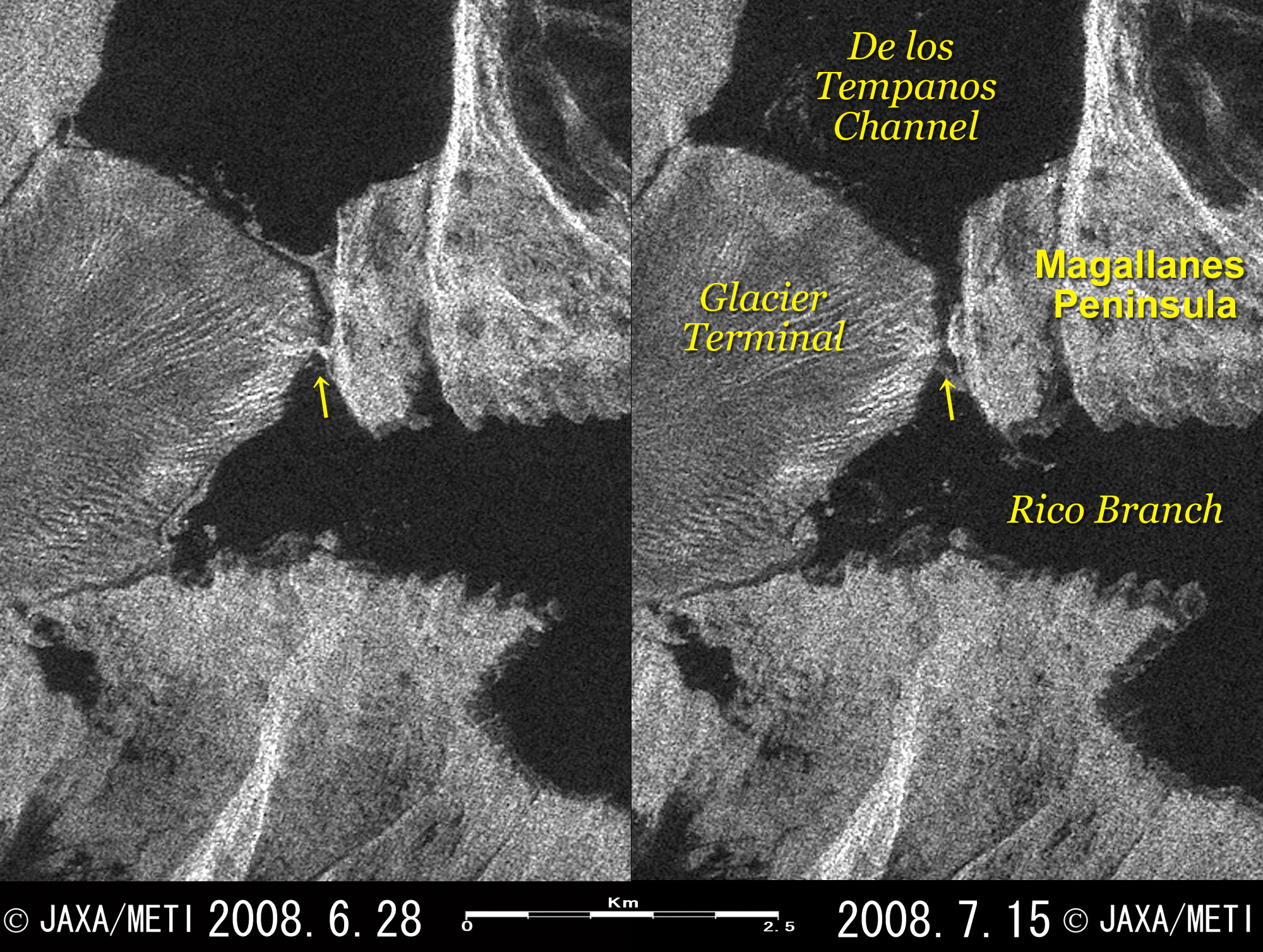
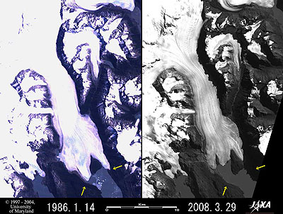
| Fig. 1. Before and after Terminal of Perito Moreno Glacier Collapses |
The news reported that the 60m-high, arch-shaped terminal of Perito Moreno Glacier in Patagonia, South America, broke off in midwinter on July 9, 2008. The left image in Fig. 1 was observed by PALSAR aboard the Advanced Land Observing Satellite "Daichi" before and the right image after the event.
The arrow in the left image indicates a bright bridge extending from the terminal of the glacier to the Magallanes Peninsula. In the right image, you can see a 60m-wide black crack between the terminal of the glacier and the Magallanes Peninsula instead of the bright surface. Comparing the images on either side reveals the place where the arch-shaped terminal of the glacier collapsed and a waterway was formed between Brazo Rico (Rico Branch) and the Canal de los Témpanos (De los Tempanos Channel). Comparing the surface area upstream of Brazo Rico reveals that the surface area on the right side is smaller after the collapse. This means that the water of Brazo Rico, which had been held back by the terminal, flowed via the above waterway into the Canal de los Témpanos and that the water level has fallen.
If the terminal of Perito Moreno Glacier reaches Magallanes Peninsula, it holds back upstream water of Brazo Rico. As a result, the level difference between the Canal de los Témpanos in the downstream and Brazo Rico increases gradually, and the water flow under the terminal of the glacier becomes faster and makes a hole in the lower part of the glacier terminal. The hole then gradually becomes larger, and the remaining arch-shaped terminal sometimes collapses. This cycle has been repeated. The news reported that such a large-scale collapse in winter in the Southern Hemisphere is very uncommon, though the event occurs around the end of summer every several years.
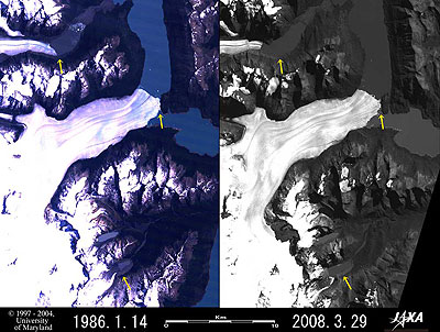 |
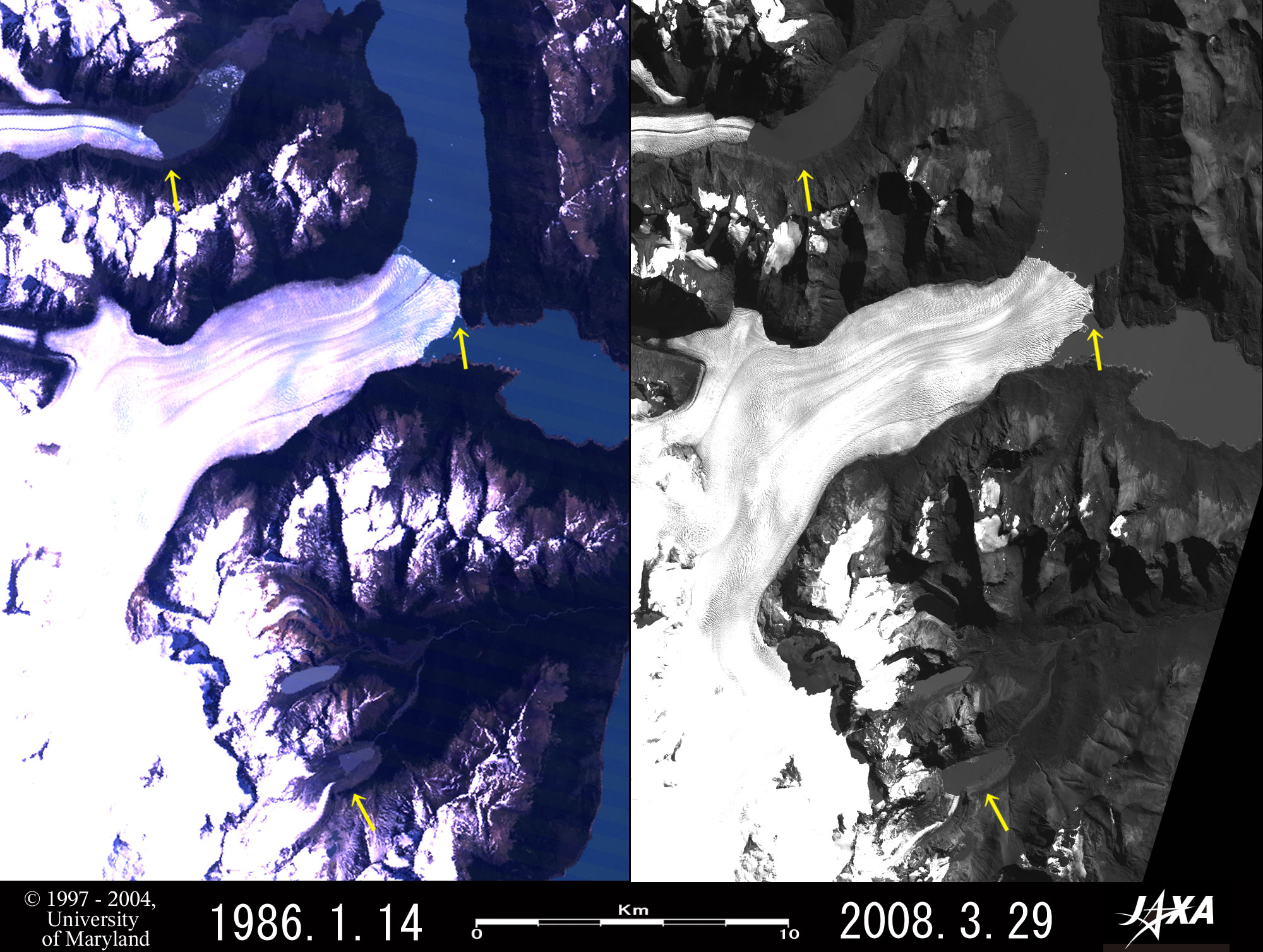
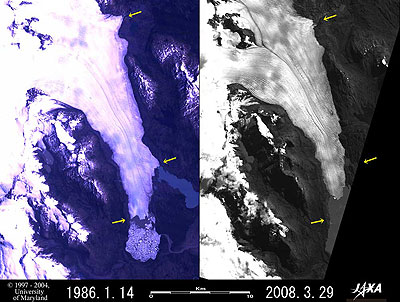
| Fig. 2. Perito Moreno Glacier |
Figure 2 presents an image of Perito Moreno Glacier. The left side indicates the status in January 1986; the right side, that in March 2008. The width of the middle courses of the glacier reaches 5km, and the length reaches more than 32km; pale stripes can also be seen.
The Perito Moreno Glacier terminal, indicated by the arrow in the upper right, reaches the Magallanes Peninsula on the opposite shore in both sides of the image. The position of the terminal has hardly changed during the last 22 years, so no retreat is visible. However, the arrow in the upper left indicates a small glacier that has retreated about 2km, and the arrow on the bottom points to a glacial lake that has more than doubled in area. The yellow arrows on both sides of the figure were drawn in the same position. Perito Moreno Glacier, that flows into Lake Argentino, is included in UNESCO’s world natural heritage site, Los Glaciares National Park on the Argentine side, and is well known as a glacier terminal that collapses with thunderous splashes. Please refer to Fig. 2 of "Huge glaciers retreat on a large scale in Patagonia, South America" for the location of the glaciers.
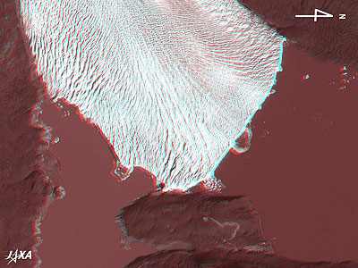 |
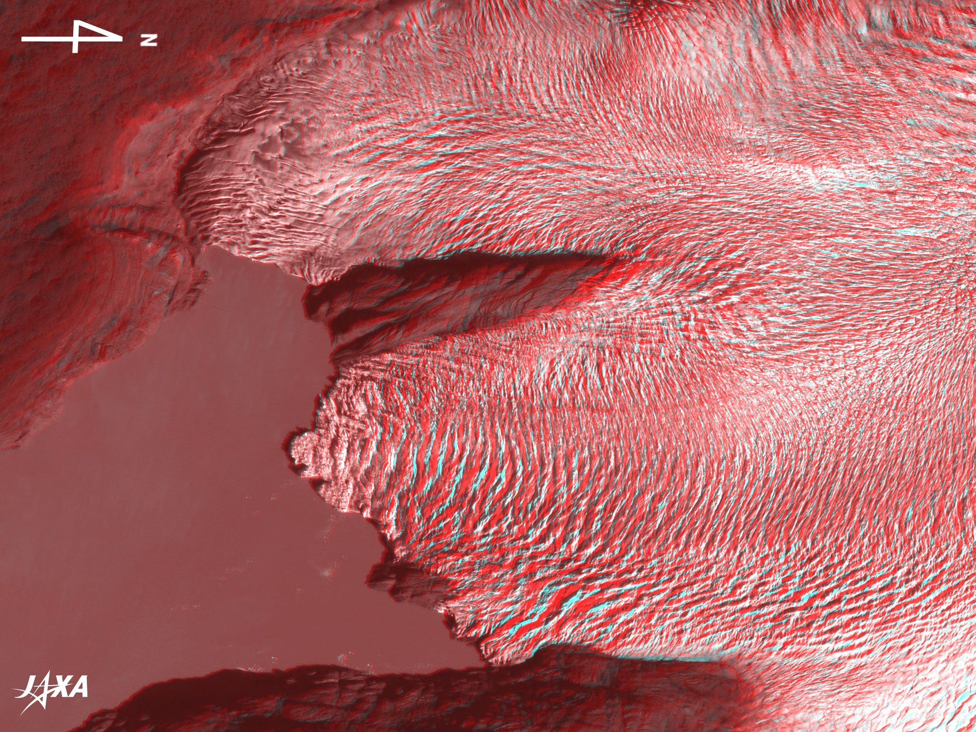
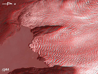
| Fig. 3. Three-Dimensional View of the Terminal of Perito Moreno Glacier
(Staring at the image for a long time may cause eye-strain. A color print is available in pdf format. Pdf files for the left and right eyes are also available for stereoscopic viewing.) |
Figure 3 depicts the terminal of Perito Moreno Glacier as observed by ALOS in March 2008. If you view the image through red and blue glasses, you can clearly see that the terminal of the glacier is a cliff. On the lake surface near the terminal, there are some icebergs and rings, which were formed after the collapse of the glacier terminal. Comparing the surface of Brazo Rico on the left side of the figure and the surface of the Canal de los Témpanos on the right side suggests that the surface level of Brazo Rico is higher. An observatory is located at the tip of the Magallanes Peninsula at the bottom of the figure.
 |
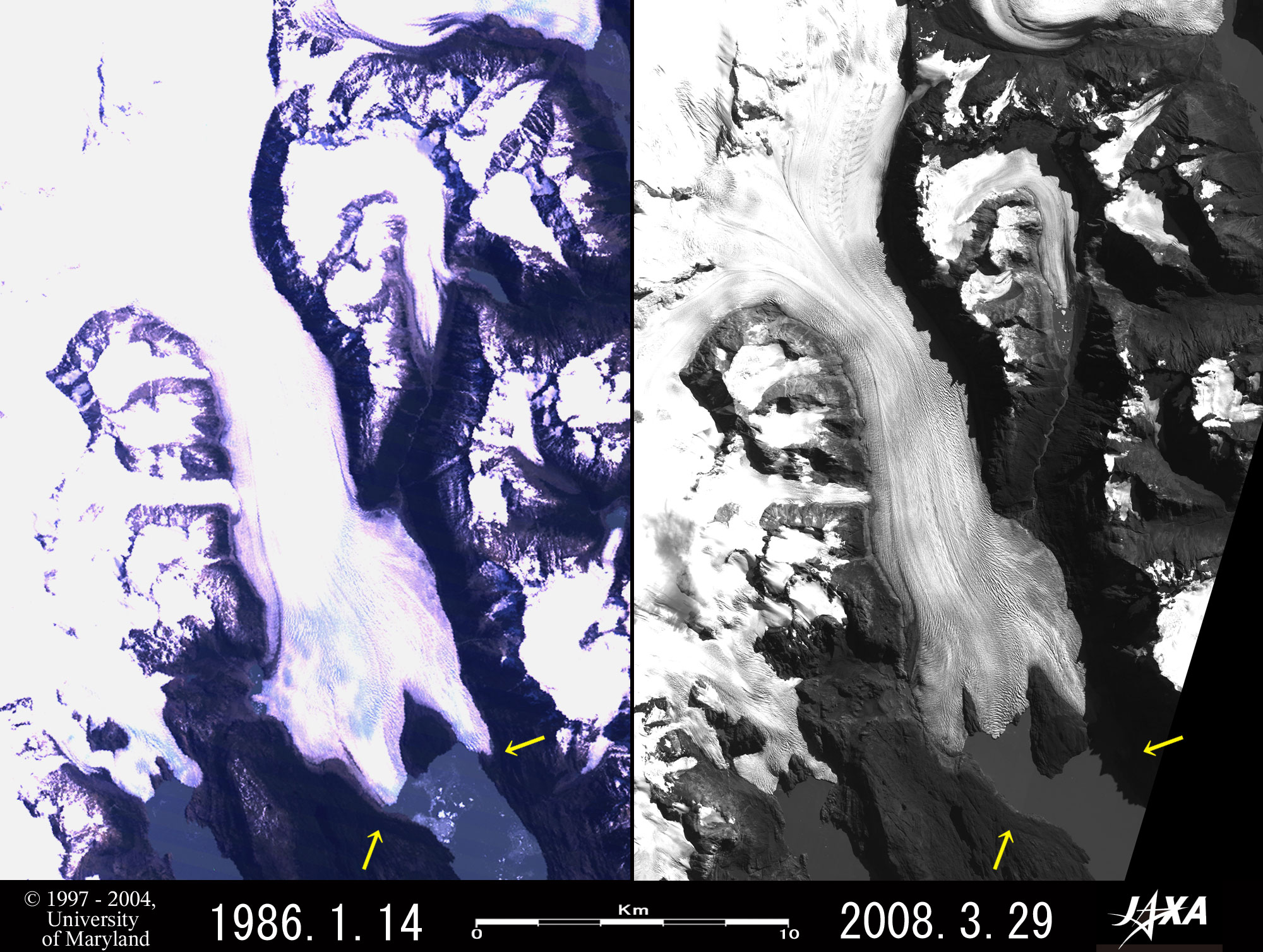
| Fig. 4. Retreat of Grey Glacier |
The Grey Glacier and the following Tyndall Glacier are located in Torres del Paine National Park on the Chilean side. Figure 4 depicts Grey Glacier that flows into Lake Grey in January 1986 and in March 2008. The lower reach of the glacier is 5.3km wide and more than 40km long; pale stripes can also be seen. The yellow arrows were drawn in the same position on either side, and the glacier terminal has obviously retreated 2.3km in 22 years. This means that the glacier has retreated some 100m a year on average. In 1986, the terminal was forked and looked like the pincers of a crab, but in 2008, it has three forks and looks like a baby’s hand.
 |
| Fig. 5. Three-Dimensional View of the Grey Glacier Terminal
(Staring at the image for a long time may cause eye-strain. A color print is available in pdf format. Pdf files for the left and right eyes are also available for stereoscopic viewing.) |
Figure 5 presents the status of the terminal of Grey Glacier observed by ALOS in March 2008. You can clearly see that the surface of the glacier has a lot of deeply inscribed wrinkles and looks like a pin cushion.
 |
| Fig. 6. Retreat of Tyndall Glacier
|
Figure 6 depicts the status of Tyndall Glacier, which flows into the Lake Tyndall, in January 1986 and in March 2008. The width of the midstream of the glacier reaches 9.6km, the length reaches more than 42km, and pale streams can be seen. The yellow arrows drawn in the same position on either side indicate that the terminal of the glacier has retreated 1.6km in about 22 years at the place of the lower arrows, or an average of 70m a year. The center right arrows indicate that the glacier width has decreased from 4.2km to 2.2km in 22 years. The width has also decreased in the area marked by the top arrows, and the whole Tyndall glacier has wasted away.
Reference
* Hokkaido University Patagonia Project Committee, Hyoga to iwa to mori no kuni (in Japanese) (the country of the glaciers, rocks and forests), Hokkaido University Press, 1974
Reference Site
 How to make the red and blue colored glasses(See Appendix of Three-Dimensional View of Mt. Haruna.) How to make the red and blue colored glasses(See Appendix of Three-Dimensional View of Mt. Haruna.)
Explanation of the Images:
(Click the images twice to enlarge.)
Fig. 1
Both the left and right images of Fig. 1 indicate the strength of the SAR-transmitted radio signal as it is scattered back by the Earth's surface. Water surfaces and slopes parallel to the transmitted direction of the radar signals, which tend to reflect radar signals forward, look black. Glaciers and slopes perpendicular to the transmitted direction of the radar signals, which reflect radar signals back to the radar, look bright. This is a powerful demonstration of SAR's ability to observe the Earth's surface regardless of clouds or daylight conditions because this season is winter in the southern hemisphere and the sun light is weak at high latitudes in winter. We developed PALSAR by improving the functions and performance of the synthetic aperture radar (SAR) that flew aboard JERS-1.
Left sides of Figs. 2, 4 and 6
Here, we used data downloaded free of charge from the site of Global Land Cover Facility (GLCF) Earth Science Data Interface operated by the University of Maryland, USA.
The images were composed by assigning red to visible Band 3 (630 to 690nm), green to visible Band 2 (520 to 600nm), and blue to visible Band 1 (450 to 520nm). The resulting images have natural coloring as if seen by the naked eye. In these images, snow, ice and clouds are white or pale purple, exposed rocks are dark brown, and water surfaces are blue or grey.
Right sides of Figs. 2, 4 and 6; Left sides of Figs. 2, 3 and 5
PRISM is an optical sensor for observing ground surfaces with visible and near-infrared signals in the 520 to 770 nanometer (one-billionth of a meter) band. The acquired image is monochrome. PRISM has three independent optical systems (telescopes) to acquire images for nadir, forward, and backward views at the same time so that terrain data including altitude data can be obtained.
The right sides of Figs. 2 and 4 and the left side of Fig. 2 are the nadir-looking images, and the right side of Fig. 6 is the backward-looking image. Figure 3 was composed using the nadir-looking image (red) and the forward-looking image (green and blue). Figure 5 was composed using the backward-looking image (red) and the nadir-looking image (green and blue). The satellite is traveling to the left because the nadir view from the satellite is seen with the left eye and the forward view with the right eye; or the backward view from the satellite is seen with the left eye and the nadir view with the right eye. Note that the right side is north in Figs. 3 and 5, but the upper side is north in the other figures.
|
|