| |
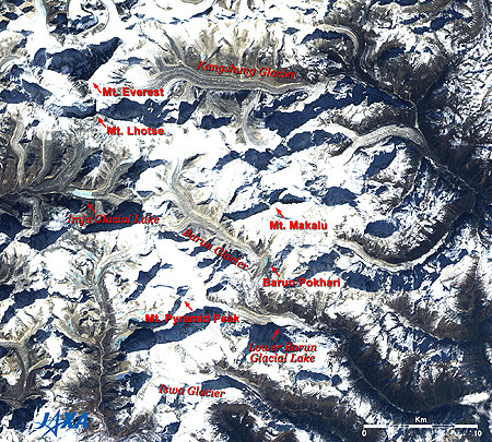 |
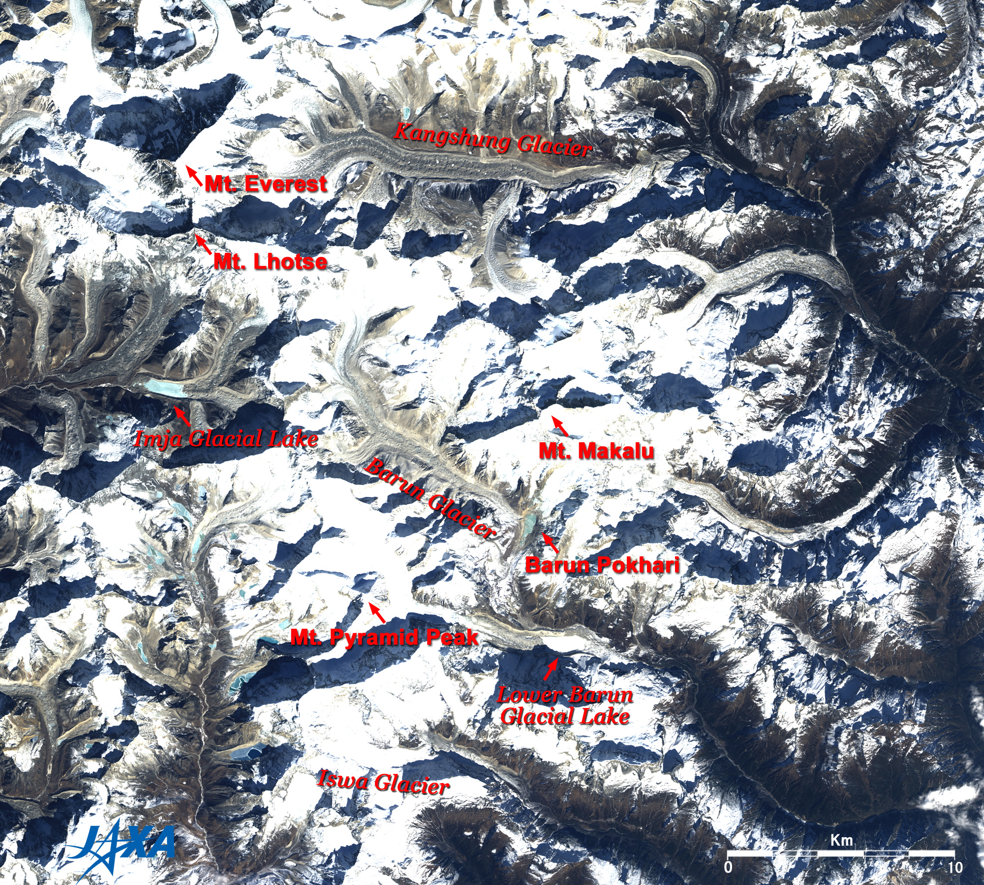
Fig. 1 Image around Mt. Makalu
Makalu (kmz, 3.90MB, Low Resolution) is seen from Google Earth.
(Full Image) |
Figure 1 depicts the world's fifth highest peak, Mt. Makalu (8,463m above sea level), situated about 20km southeast of the world's highest peak, Mt. Everest (8,848m), and the surrounding mountains in the Himalayas in January 2007. The steep summits and ridges of the mountains cast their own shadows toward the upper left due to the sunlight from the southeast. Mt. Makalu can be seen at the center of the figure, and Mt. Everest and the world's fourth highest peak, Mt. Lhotse (8,516m), in the upper left.
The Barun Glacier flows on the west side of Mt. Makalu, and the Lower Barun Glacier on the southwestern side. Light-blue Barun Pokhari (lake) and the Lower Barun Glacial Lake, with its white frozen surface, can be seen at the ends of the glaciers. Additionally, numerous glaciers appear as a line of white or light brown color, and the glacial lakes are white or light blue. Mt. Pyramid Peak (6,809m) is located 11km southwest of Mt. Makalu. If you look closely, you can see a square pyramid.
The upper right half of the figure is Chinese Tibet, and the lower left half is Nepal. Mt. Everest, Mt. Lhotse and Mt. Makalu are on the border.
They say that the name "Makalu" in Tibetan was corrupted from "Kamalun" by connecting "Karma" valley, into which the Kangshung Glacier on the north side of Mt. Makalu flows, and "lun (area, valley)."
 |
 |
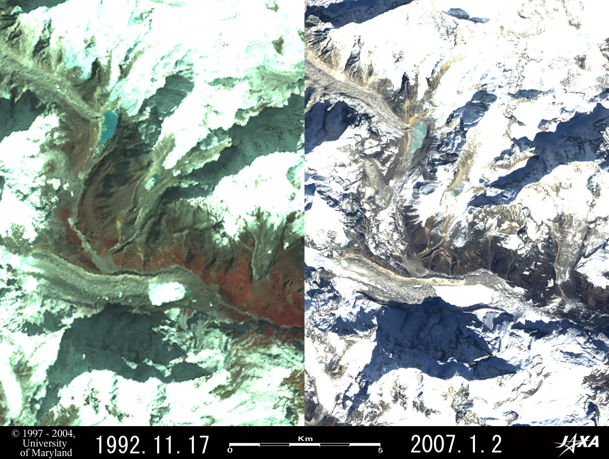
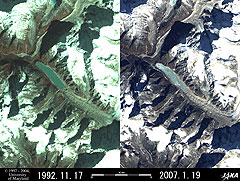
| (a) Lower Barun Glacial Lake |
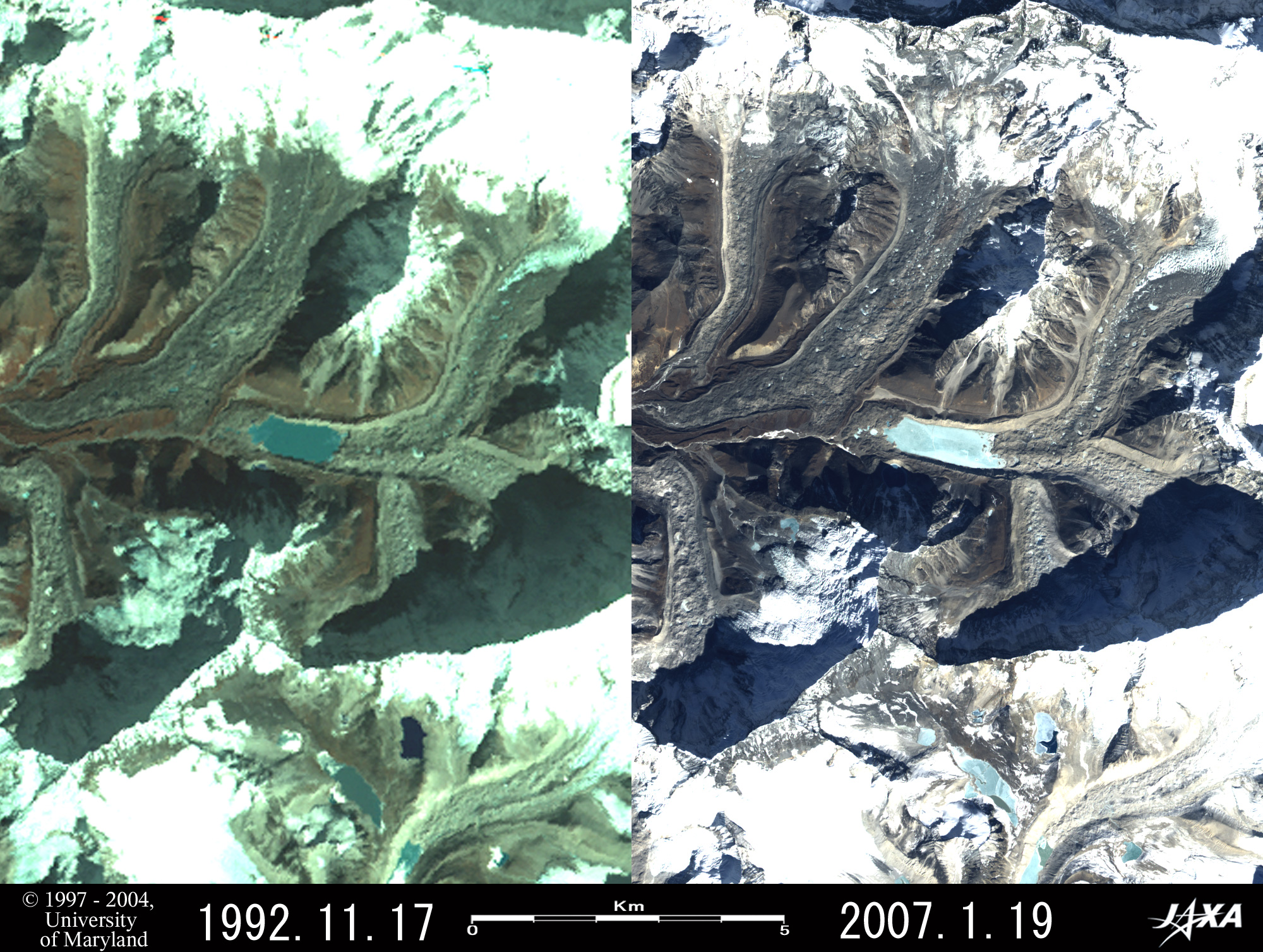
(b) Imja Glacial Lake |
 |
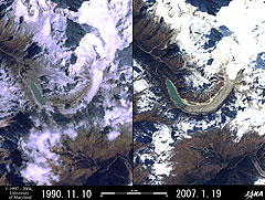 |
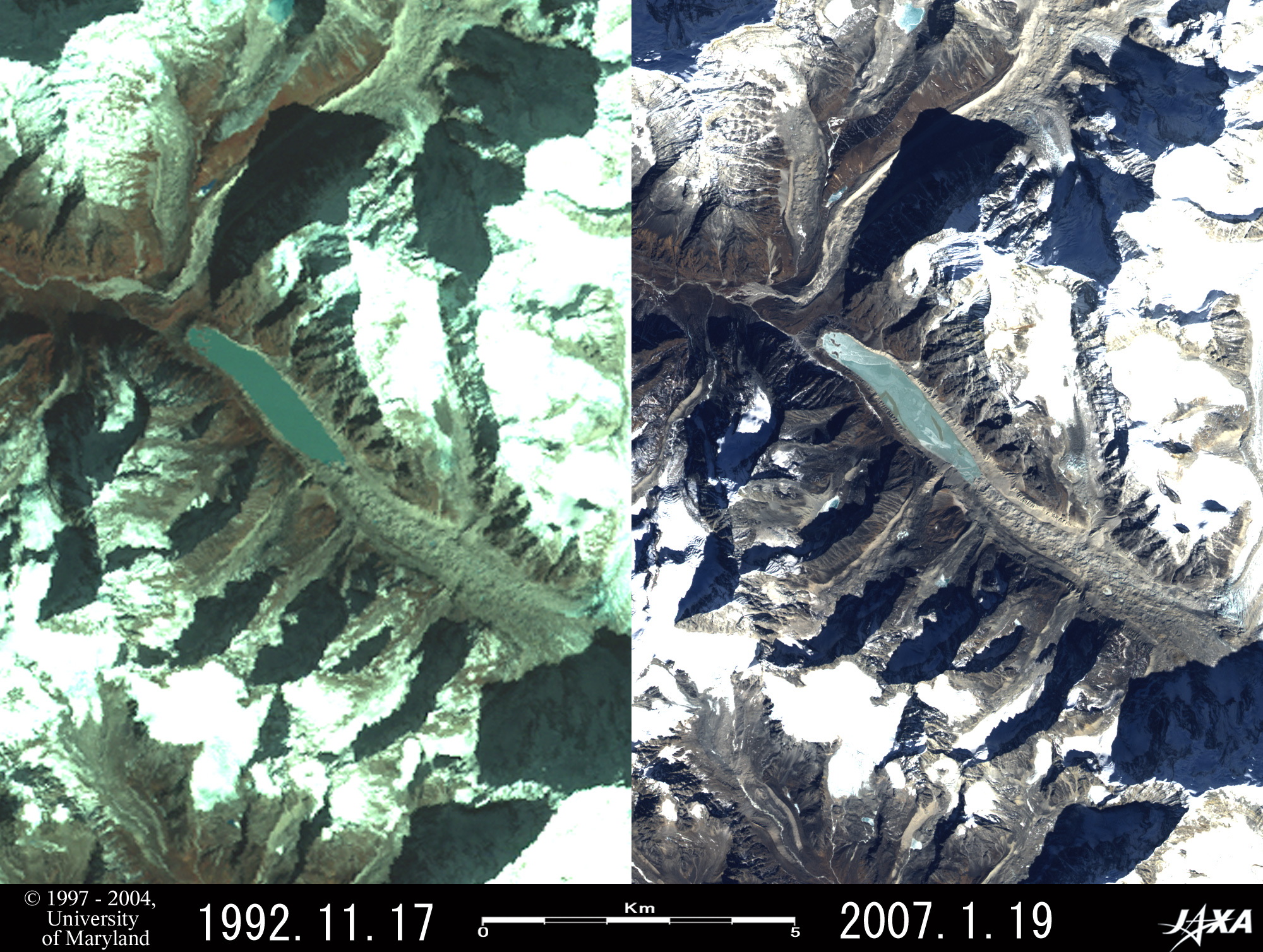
| (c) Tsho Rolpa Glacial Lake |
(d) Thulagi Glacial Lake |
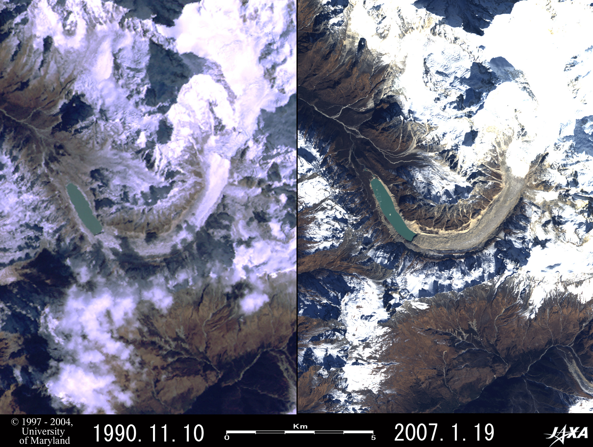
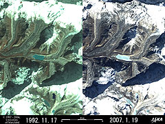
| Fig. 2 Comparison of the potentially dangerous glacial lakes in Nepalese Himalaya |
Figures 2a to 2d present comparative images of the major glacial lakes on the Nepalese side of the Himalayas. The United Nations Environment Programme's (UNEP's) report* warns of bursting of these glacial lakes.
The left side of each figure is the image observed by Landsat 5 in 1990 or 1992, and the right side is that observed by Daichi (ALOS) in 2007. Comparing the images reveals the changes in the last 15 to 17 years.
| Table 1 Size changes of the potentially dangerous glacial lakes in Nepalese Himalaya |
| Glacial Lake |
Lower Barun |
Imja |
Tsho Rolpa |
Thulagi |
| Location |
10km south of Mt. Makalu |
9km south of Mt. Everest |
46km west-southwest of Mt. Everest |
10km southwest of Mt. Manaslu |
| Altitude (above sea level)* |
4,570m |
5,000m |
4,580m |
4,146m |
| (Observation Years)
|
(1992)→(2007) |
(1992)→(2007) |
(1992)→(2007) |
(1990)→(2007) |
| Width(km) |
0.6→0.6 |
0.6→0.6 |
0.6→0.6 |
0.4→0.4 |
| Length(km) |
1.2→2.0 |
1.5→1.7~2.0 |
3.2→3.4 |
2.0→2.4 |
| Area(km2) |
0.75→1.09 |
0.69→0.93 |
1.49→1.52 |
0.76→0.93 |
| Changes of areas |
+45% |
+35% |
+2% |
+22% |
Table 1 was made by reading the size of each glacial lake in Fig. 2 each year. Every lake is higher than Mt. Fuji (3,776m) in Japan, and every lake surface area has increased. The increase of the lake surface area of Tsho Rolpa Glacial Lake remains at 2% because some effective measures were taken. For example, the Nepalese government established some siphons for the drainage after 1997, and an outlet and outlet canal were constructed in the moraine (lodgment carried by the glacier) that forms a dam with the Netherlands financial support from 1998 to 2002.
In contrast, the areas of other glacial lakes increased by 22 to 45%. An increased lake surface area means a higher lake surface level and greater stored water volume that may lead to the increased possibility of an outburst and greater potential damage. Therefore, the water level must be lowered immediately by constructing outlets, draining water with the pumps and the siphons, etc.
* "Inventory of Glaciers, Glacial Lakes and Glacial Lake Outburst Floods Nepal," United Nations Environment Programme (UNEP) & International Centre for Integrated Mountain Development (ICIMD), 2002
References:
Himalaya Meihou Jiten (in Japanese), Heibonsha Ltd., 1996
|
Explanation of the Images:
Fig. 1, Full Image and right side of Figs. 2a to 2d. Enlarge the images by clicking once or twice.
AVNIR-2 has four observation bands. Figure 1, full Image and the right side of Figs. 2a to 2d were composed by assigning red to visible Band 3 (610 to 690nm), green to visible Band 2 (520 to 600nm), and blue to visible Band 1 (420 to 500nm). The resulting image has natural coloring as if seen by the naked eye. In these images, snow and clouds are white; glaciers are white or light brown; exposed rocks, soil and sand are brownish; and hay is dark brown. Areas with no data are black.
Left side of Figs. 2a to 2d. Click figures twice to expand them.
| Satellite: |
Landsat-5 (USA) |
| Sensor: |
Thematic Mapper (TM) |
| Date: |
November 17, 1992 (UTC) (left side of Figs. 2a to 2c)
November 10, 1990 (UTC) (left side of Fig. 2d)
|
| Ground resolution: |
30m |
| Map Projection: |
Universal Transversal Mercator (UTM) |
Here we used data downloaded free of charge from the site of Global Land Cover Facility (GLCF) Earth Science Data Interface operated by University of Maryland, USA. These figures were composed by assigning red to near infrared Band 4 (760 to 900nm), green to visible Band 3 (630 to 690nm), and blue to visible Band 2 (520 to 600nm). The resulting image has different coloring from that seen by the naked eye. In these images, snow and ice are white or light blue, forests are auburn, and exposed rocks are olive green or grey. |
 |
|