


- Overview
- Scientific Team members
- The ALOS Systematic Observation Strategy
- The ALOS-2 Systematic Observation Strategy
- Scientific reports for K&C Phase 1 (2006-2008)
- Scientific reports for K&C Phase 2 (2009-2011)
- Scientific reports for K&C Phase 3 (2011-2014) (PDF file / 123MB)
- Scientific reports for K&C Phase 4 (2015-2019) (PDF file / 141MB)

- The K&C Global Mangrove Watch
- References
- Related links
Over recent decades, significant changes in the extent and composition of mangroves in response to environmental change have been observed in mangrove ecosystems worldwide. With the predicted climate changes forecast for this century, including sea level rise, increasing temperatures and storm activity, acceleration in the natural processes of change may occur. Furthermore, direct clearance of mangroves and conversion of mangrove to other land uses, including in particular aquaculture, is occurring at an alarming rate and, in many cases, the extent of clearance is unknown.
These changes can take place over decades but can also be very rapid, and updated information on their change status is therefore required on a regular basis. For countries reporting on the UN Sustainable Development Goals or participating in the REDD+ scheme, information about mangrove extents and changes over time is of critical importance.
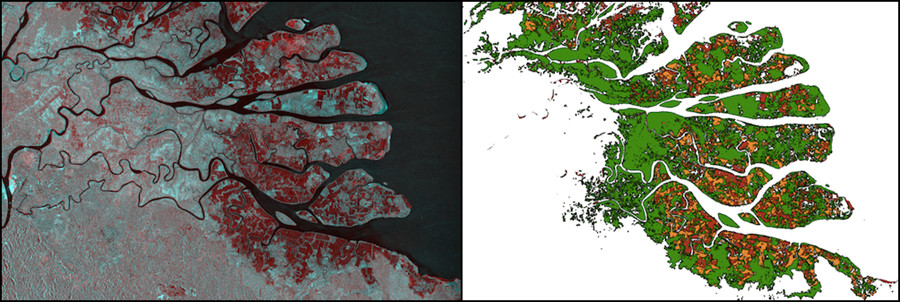
Kahan river delta, North Kalimantan, Indonesia. (a–Left) Multi- temporal SAR composite (1996 JERS-1 SAR and 2016 ALOS-2 PALSAR-2) (b–Right) Mangrove extent and changes, Red – mangroves lost 1996-2007, Orange – loss 2007-2016, Green – mangrove cover in 2016.
While cloud cover limits the use of optical satellite data in tropical and sub-tropical regions, Synthetic Aperture Radar sensors are particularly well suited for mangrove monitoring as SAR data can be acquired regardless of clouds, smoke and haze. L-band SAR is particularly suitable as it is sensitive to both vegetation structure and to detect changes in time-series of data. With JAXA’s JERS-1 SAR, ALOS PALSAR and ALOS-2 PALSAR-2 missions a consistent L-band SAR data record spanning over two decades is available and provides a unique opportunity to map the extents and changes of the global mangrove cover the past 20 years.
The Global Mangrove Watch (GMW) was initiated as part of the K&C Initiative in 2011. It is led by Aberystwyth University (U.K.) and solo Earth Observation (Japan), in collaboration with Wetlands International, the International Water Management Institute (Sri Lanka) and the UNEP World Conservation Monitoring Centre (U.K.). The GMW aims to provide geospatial information about mangrove extent and changes to the Ramsar Convention, national wetland practitioners, decision makers and NGOs. The primary objective of the GMW has been to provide countries lacking a national mangrove monitoring system with first cut mangrove extent and change maps, to help safeguard against further mangrove forest loss and degradation.
The GMW has generated a global baseline map of mangroves for 2010 using ALOS PALSAR and Landsat (optical) data, and changes from this baseline for seven epochs between 1996 and 2016 derived from JERS-1, ALOS and ALOS-2. Annual maps are planned from 2017 and onwards. The mangrove maps are publicly available through the World Resources Institute (WRI) Global Forest Watch portal (http://www.globalforestwatch.org) and for public (free of charge) download via the UNEP World Conservation Monitoring Centre, Ocean Data Viewer
Dr. Ake Rosenqvist, GMW and K&C Science Coordinator
solo Earth Observation (soloEO)
Tokyo 104-0054, Japan
Email:
Prof. Richard Lucas (GMW scientific lead)
Dr. Pete Bunting (GMW technical lead)
Institute of Geography and Earth Sciences
Aberystwyth University
SY23 3DB Wales, UK
Email:
Email:
Dr. Lisa Maria Rebelo (K&C Wetlands Theme Coordinator)
International Water Management Institute (IWMI)
Colombo, Sri Lanka
Email: