| |
 |
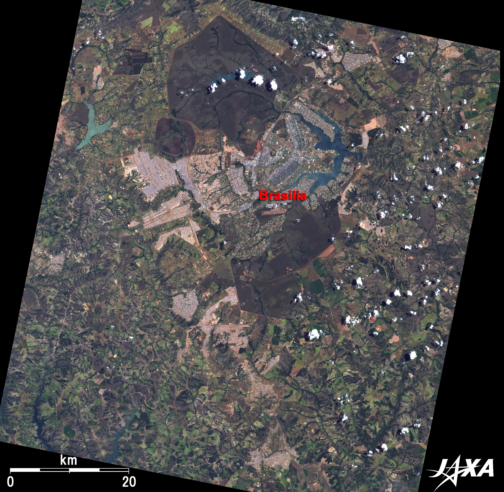
| Fig. 1. Vicinity of Brasilia |
Figure 1 depicts the vicinity of Brasilia, the capital of the Federative Republic of Brazil, as observed in March 2007. President Juscelino Kubitschek relocated the capital from Rio de Janeiro to Brasilia on the vast Central Plateau of Brazil in 1960.
The large airplane (or bird-in-flight) shaped area, just a little north of the figure center, is Brasilia. Conceived by the Brazilian urban planner Lúcio Costa, the city was constructed in only three and a half years and incorporated two large intersecting avenues, an artificial lake, and innovative and imaginative mid-to-high-rise buildings. New areas with novelly designed buildings are now being added.
This Federal District used to be a sparsely populated, poor red soil Cerrado area. The "cerrado" (meaning "closed" or "inaccessible" in Portuguese) is the name of a tropical savanna flora in mid-west Brazil. It was a vast wild land of about 200 million hectares (more than 5.5 times larger than Japan). Much green farm land has spread over the ground around Brasilia, indicating that the Cerrado agricultural development is progressing conjointly with the governmental aid policy.
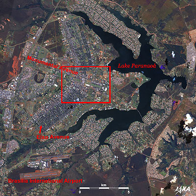 |
Fig. 2. Urban Area of Brasilia
Brazil, Brasilia (kmz, 4.57 MB, Low Resolution) as seen on Google Earth. |
The 9.75km-long street running east and west, with a wide lawn in its green center mall, is Monumental Avenue, which constitutes the fuselage of the airplane. A 14.3km-long street running north and south, penetrating the residential area, is Eixo Avenue, which composes the wings of the airplane. Man-made Lake ParanoEis located to the right (east) of the image center. Foreign embassies, educational facilities, and sports and amusement facilities are located between the wings and the lake. An exclusive residential area for single-family houses is located on the opposite bank. Brasilia International Airport (visible in the lower left) is a major hub airport for the rest of the country, connecting the capital to all major Brazilian cities and many international destinations.
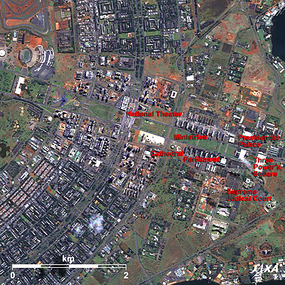 |
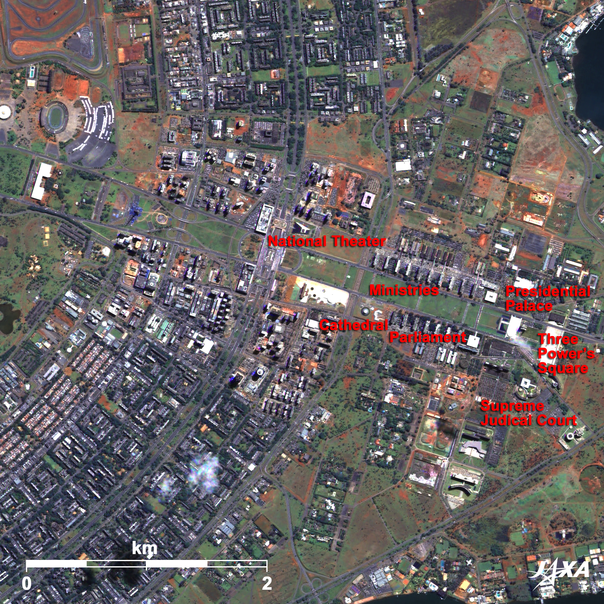
| Fig. 3. Close-up of Central Brasilia |
The green lawn of Monumental Avenue’s central mall is clearly visible. This avenue has six-lanes each way and sectors for administration, business, hotels, and TV and radio stations are orderly arranged along the avenue. Many uniquely designed buildings can be seen in this area. Located on the right side of the figure, equivalent to the nose of the airplane, is the Three PowersESquare surrounded by the Parliament, Supreme Judicial Court, and Presidential Palace. Toward the direction of the tail are located the Foreign Ministry, Justice Ministry, etc. as well as the Cathedral of Brasilia, the National Theater, and a TV tower. Parliament, the Cathedral, and the Presidential Palace were designed by the most important architect in the world, Brazilian Oscar Niemeyer, who also designed the United Nation’s Headquarters Building in New York.
Eixo (Eixão ) Avenue is a high-speed highway with three lanes each way. Parallel to the Eixo, there is an Eixinhos (frontage road) on each side,four lanes each, which facilitate access to loops and local streets.
Both sides of Eixo are divided by city blocks (quadra or quadro in Portuguese) of 240m meters square each, in which stand seven-story apartment houses (six-story residences and piloti). (In modern architecture, pilotis are ground-level columns supporting houses or offices.)
Brasilia was added to the World Heritage list of the United Nations Educational, Scientific and Cultural Organization (UNESCO) in 1987. Registration of a new city less than 40 years old is quite rare, but it was awarded this status because it expresses the creative masterpiece of mankind and is a world reference for urban planning of developing countries.
Explanation of the Images:
(Click the images twice to enlarge.)
Fig. 1
AVNIR-2 has four observation bands. The composite images are usually produced by assigning red to Band 3 (610 to 690nm), green to Band 2 (520 to 600nm), and blue to Band 1 (420 to 500nm). The resulting images have natural coloring as if seen by the naked eye. Thus, the following colors designate ground objects.
| Green: |
Forests |
| Light green: |
Farmlands or grass fields |
| Grey: |
City area or roads |
| Brown: |
Bare land |
| Blue: |
Water surfaces |
Figs. 2 and 3
PRISM is an optical sensor for observing ground surfaces in the visible and near-infrared bands (520 to 770 nano-meter (one-billionth of a meter)). The acquired image is monochrome. PRISM has three independent optical systems (telescopes) to acquire images for nadir, forward, and backward views at the same time. Only the nadir image was used in this article.
The above AVNIR-2 composite image was then transformed into hue, saturation, and intensity, and the intensity was replaced by the PRISM image. The hue, saturation, and intensity data were then reversed into a color image. As a result, a virtual 2.5-m ground resolution color image was obtained. This kind of high-resolution color image, composed by combining a higher-resolution monochrome image and a lower-resolution color image, is called a pan-sharpened image.
|
|