Seen from Space 2008
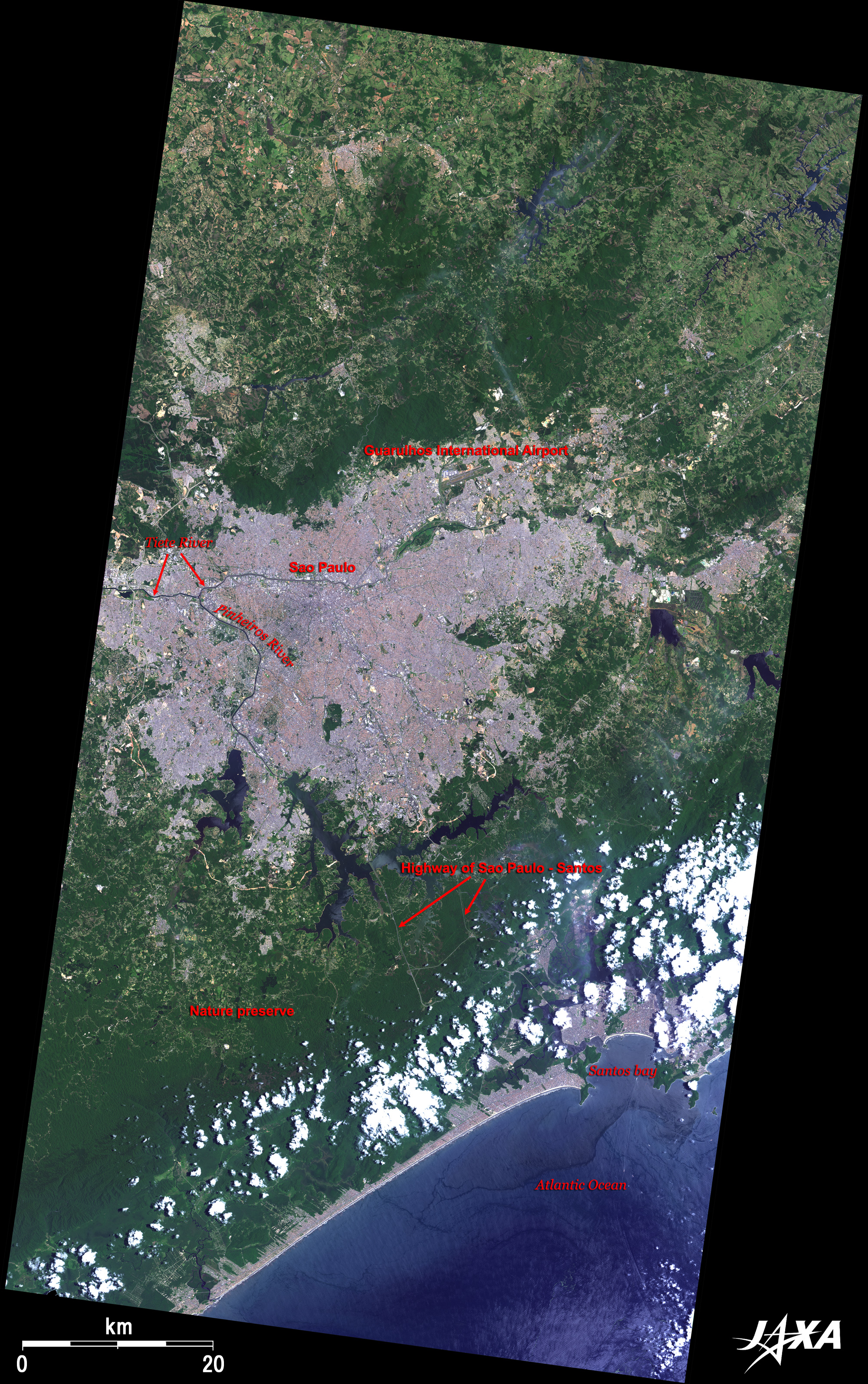
The City with a 100-Year History of Immigration: São Paulo Brazil
The Tietê River, which is the main artery of São Paulo, was once so badly contaminated as to be called the "river of death" and induced various kind of pollutions such as polluting gas. However, it has gradually been restored by civilian efforts. Japanese ODA supports this restoration project. The coastline and Santos Bay facing the Atlantic Ocean are visible in the lower part of the image. The Port of Santos in Santos Bay, which once thrived as a coffee shipping port, is now mainly shipping soybeans. The Port of Santos is located about 60km south of São Paulo, and highways connecting the two cities are visible as grey lines in the forest. The narrow strip of land bounded by the green highland and a 40km plus straight coast line is an orderly arranged residential and resort area extending from the coast to the mountains. The area from the coast to São Paulo at about 800m above sea level is designated as a national preservation area and untouched forests and grass lands remain.
Congonhas International Airport visible in the lower part of the image is the busiest airport in Brazil, but, due to its short runways, is now mainly used for domestic shuttle flights to/from Rio de Janeiro and Brazilia. Campo de Marte (Base Ae'rea de Marte) Airport visible to the north of the Tietê River is the fifth busiest airport in Brazil, and Guarulhos International Airport in Fig. 1 is the second busiest. Liberdade district, once called "Japan Town" where many Japanese immigrants settled, is visible in the center of the figure. Immigrants from Korea and China have also increased, so the area is now called "The Asian Quarter." This area is filled with hotels, Japanese food restaurants, book stores handling Japanese books and Japanese style souvenir shops run by Japanese Brazilians. The center of this district is the Liberdade Square above the Liberdade Metro Station, where an oriental market is held every Sunday. Osaka-basi (an overhead bridge) and a red torii (a Japanese arch that marks the entrance to Shinto temples) are also popular in this district. Located to the southwest of Liberdade district is the triangular-shaped green Ibirapuera Park, the largest park in São Paulo, which was landscaped in 1945 to commemorate the city's 400th anniversary of municipalization. This is one of the most popular green areas for recreation and relaxation for the citizens of São Paulo. There are jogging courses, cycling roads, multimedia fountains, modern art museums, a Japanese pavilion, and public halls in the park. Museum Paulista (Museu Paulista - Ipiranga) is visible about 5km east of Ibirapuera Park. It was built in 1890 to commemorate the independence of Brazil, and the garden modeled on the Palace of Versailles in France was built in 1908. São Paulo Museum of Art (MASP: Museu de Arte de São Paulo), built in 1969 and located about 2km north of Ibirapuera Park adjacent to the rectangular Trianon Park (Patque Tenente Siqueira Campos), is a elevated-floor building supported by four pillars. The museum holds thousands of fine European works ranging from the Middle Ages to the present. The main street between Trianon Park and the São Paulo Museum of Art (MASP) is Paulista Avenue, the birthplace of São Paulo, and formerly the location of the mansions of coffee farm owners during the time when São Paulo prospered from coffee exports. At present, this avenue is the largest office area in São Paulo. The remarkable white elliptic shape on the west coast of the Pinheiros River is a horse race track. The University of São Paulo (USP) and its vast campus are visible to the northwest of the racetrack. In 1934, the USP was established to integrate existing colleges and various faculties that had been scattered around the city, and the 5-million square meter campus was built in the early 1960's. Its scale and modern facilities now make USP a great asset for scholarship in Brazil. The year 2008 is the "The Year of Japan-Brazil Exchange" commemorating the centenary of Japanese emigration to Brazil. The first 781 Japanese emigrants and 10 other passengers on board the Kasado-Maru left the Port of Kobe bound for Brazil on 28 April 1908 and arrived in the Port of Santos on 18 June. On arrival, they immediately took the train to the Immigrants Asylum (in the center of Fig. 2; now called the Immigrants Museum). They then scattered to the coffee farms in São Paulo as employed farmers. It is estimated that about 250 thousand such people crossed the oceans before the last emigrants departed to Brazil in 1971. Today, Japanese-Brazilians are about 1.5 million strong, about 1 million of whom live in the state of São Paulo where they form the largest overseas Japanese community.
|