ページの先頭です。
本文へジャンプする。
【Important Notices】This page is an archive page of information published in the past. Since the update has been completed, it may contain broken links or outdated information. For the latest information, please use the new site Earth-graphy (earth.jaxa.jp).
ここからサイト内共通メニューです。
サイト内共通メニューを読み飛ばす。
サイト内共通メニューここまで。
ここから本文です。

Seen from Space 2008

Lisbon, Portugal - Where the Land Ends and the Sea Begins

 
Fig. 1. Lisbon and Vicinity
Figure 1 presents an image of Lisbon (Portuguese: Lisboa), the capital of Portugal, and its vicinity. The Phoenicians used Lisbon as a port since 1200 B.C., when it was named "Allis Ubbo" in Phoenician. Lisbon came from the port name "Allis Ubbo." Lisbon is the largest port town in Portugal and has evolved on the mouth of the Tagus River, the longest river on the Iberian Peninsula (Spanish, "Tajo"; Portuguese, "Tejo"). The river is 1,038 kilometers long, and 90% of it is in Spain. Today, Lisbon has a population of 560 thousand, which rises to 2.6 million if we include adjacent municipalities. Lisbon is also known for its many hills, like the seven-hill city, Rome.

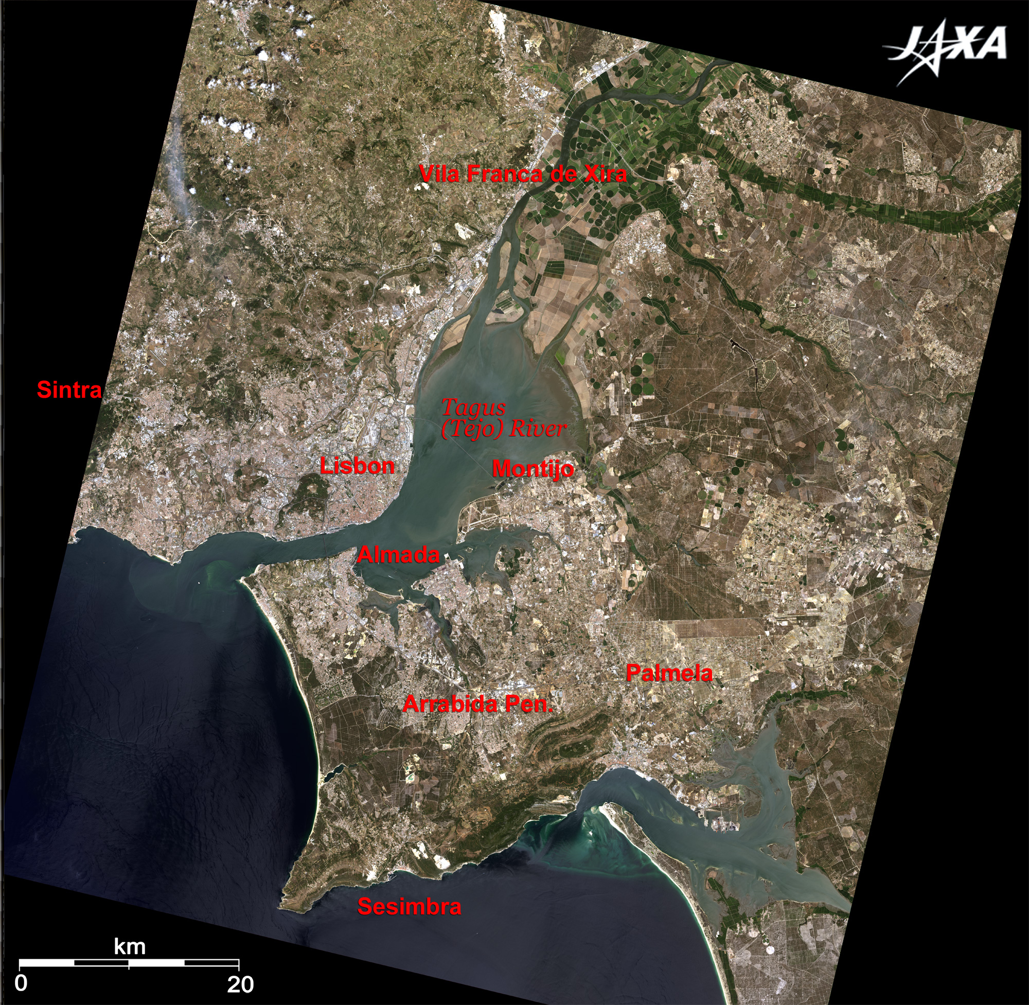
Lisbon prospered more than Venice during the Age of Discovery from the 15th century with spice trade. However, the city suffered the Great Earthquake in 1755 and was almost destroyed. The city was subsequently rebuilt and organized in a beautiful grid system.

Monument of Cristo Rei, which resembles the Corcovado monument in Rio de Janeiro, stands in Almada on the opposite bank of the river. The summer residence of 14th-century Portuguese kings was located in Sintra, 20km west of Lisbon. Sintra is a base station for visiting Cape Roca, the westernmost point of the Eurasian Continent (Cape Roca is not visible in the figure). Sintra is the location of the monument of "where the land ends and the sea begins" by Portuguese poet Luú de Camões (1524-1580). The National Palace of Pena and the castle were added to the list of World Cultural Heritage sites of the United Nations Educational, Scientific and Cultural Organization (UNESCO) in 1995 as "Cultural Landscape of Sintra."

Vila Franca de Xira, located 30km north of Lisbon and situated on the west bank of the River Tagus, is well-known for its bullfighting and bull-running festivals "Festa do Colete Encarnado." You can see large farms on the east bank of the river, and numerous circular fields with large sprinklers are clearly visible.
Sesimbra is located on the south coast of the Arrabida Peninsula and is well known for its fishing villages, fish restaurants, and resort areas for citizens of Lisbon. Palmela with Moors castle is located east of Sesimbra. Muslims and Christians in the castle battled repeatedly in the middle of the 12th century.

Fig. 2. Lisbon and its suburbs
Lisbon, Portugal (kmz, 3.97MB, Low Resolution) as seen on Google Earth.
Figure 2 depicts Lisbon and its suburbs. The bridge between Lisbon and Almada is the 25th of April Bridge, which is 2,227m long and supports a six-lane road. The bridge was named after the Carnation Revolution on April 25, 1974. The monument of Cristo Rey is at the foot of the bridge.

The longer bridge on the right is the Vasco da Gama Bridge between Sacavém and Montijo. Its 17.2km length makes it the longest bridge in Europe. Expo E8 was held in Sacavém at the foot of the bridge. The bridge was opened in 1998 and was named to commemorate the 500th anniversary of the discovery of the sea route from Europe to India by Vasco da Gama (1469-1524).

The Belém area, located west of Lisbon, is one of the most favorite places due to its many monuments of the Age of Discovery. The Bairro Alto area, a high-rise area north of Belém, is one of the oldest districts in Lisbon and is home to many Fado singing clubs and small restaurants. Alfama east of Bairro Alto is also one of the oldest districts in Lisbon and has many Fado bars and restaurants with many alleys. One of these is the Baixia area, a lowland area that was rebuilt after the Great 1755 Earthquake. It is also called Lisboa Pombalina, and its streets are laid out in grids. Lisbon Portela International airport is located north of Lisbon.

Fig. 3. Close-up of Lisbon
The Tower of Belém (also called Fortress of St. Vincent), visible west of Lisbon, was constructed in the Manueline style developed during Portuguese King Manuel I’s (1469 to 1521) reign when Portugal prospered. It was constructed for monitoring forces invading the port of Lisbon. A monument to the Discoveries (visible east of the tower) was constructed to commemorate the 500th anniversary of the death of Prince Henry the Navigator (1394 to 1460), who was the patron of Portuguese exploration of the west coast of Africa and opened the Age of Discovery. The monument is carved into the shape of the prow of a sailing ship with a statue of the Prince at the tip of the monument and statues of 27 other great people of that era.

Manuel I began the construction of the white Monastery of the Hieronymites in 1502, and it was completed 300 years later. It was funded using the enormous riches of Vasco da Gama’s spice trade. The Monastery of the Hieronymites and the Tower of Belém were added to the list of World Cultural Heritage sites of the United Nations Educational, Scientific and Cultural Organization (UNESCO) in 1983.
Commerce Square (Plaza del Cormecio) in the Baixa area is the ruins of King Manuel I’s royal residence destroyed in the Great 1755 Earthquake. Plaza Rossio is most crowded, and horseshoe-shaped Rossio station is visible in the same area. The avenue in the north from the Rossio station is Liberty Avenue (Avenida da Liberdade) and is an important avenue in central Lisbon modeled after Avenue of Champs-Élysées in Paris.
Expo E8 was held in 1998 with the theme "The Oceans, a Heritage for the Future." Most main pavilions still remain, and the Park of the Nations was opened to the public after Expo E8. It has one of the larger aquariums in Europe and a major shopping center, making it a place of recreation and relaxation for the citizens.


Explanation of the Images:
(Click the images twice to enlarge.)
Satellite: Advanced Land-Observing Satellite (ALOS) (Daichi)
Sensor:
Figs. 1 through 3: Advanced Visible and Near Infrared Radiometer-2 (AVNIR-2)
Figs. 2 and 3: Panchromatic Remote-sensing Instrument for Stereo Mapping (PRISM)
Date: 1132 (UTC) on July 22, 2007 (AVNIR-2)
1130 (UTC) on September 3, 2007 (PRISM)
Ground resolution: 10m (AVNIR-2) and 2.5m (PRISM)
Map Projection: Universal Transversal Mercator (UTM)
Fig. 1
AVNIR-2 has four observation bands. Figures 1 to 3 are produced by assigning red to Band 3 (610 to 690nm), green to Band 2 (520 to 600nm), and blue to Band 1 (420 to 500nm). The resulting images have natural coloring as if seen by the naked eye. Thus, the following colors designate ground objects.

Green: Forests
Light green: Farmlands or grass fields
Grey: City area, roads or rock surface
Reddish brown: Brick houses
Blue: Water surfaces

Figs. 2 and 3
PRISM is an optical sensor for observing ground surfaces with visible and near-infrared signals in the 520 to 770 nano-meter (one-billionth of a meter) band. The acquired image is monochrome. PRISM has three independent optical systems (telescopes) to acquire images for nadir, forward, and backward views at the same time. Only the nadir image was used in this article.
The above AVNIR-2 composite images were then transformed into hue, saturation and intensity, and the intensity was replaced by the PRISM image. The hue, saturation and intensity data were then reversed into a color image. As a result, virtual 2.5m ground-resolution color images were obtained. This kind of high-resolution color image, composed by combining the higher-resolution monochrome image and the lower-resolution color image, is called a pan-sharpened image.

Related Sites:
ALOS Research and Application Page
The Eternal Capital with a Long History: Rome
Port City KOBE "Revival from Earthquake Disaster"
1,000-Year Prosperity of the "City of Water"- Venice
Land, Seen from Space
本文ここまで。
image:Satellite Navigator
image:Satellite Applications and Operations Center(SAOC)
Earth Data Collection by JAXA Satellites
image:ページTOP