ページの先頭です。
本文へジャンプする。
【Important Notices】This page is an archive page of information published in the past. Since the update has been completed, it may contain broken links or outdated information. For the latest information, please use the new site Earth-graphy (earth.jaxa.jp).
ここからサイト内共通メニューです。
サイト内共通メニューを読み飛ばす。
サイト内共通メニューここまで。
ここから本文です。

Seen from Space 2007

Port City KOBE "Revival from Earthquake Disaster"

 
Fig. 1. Vicinity of Kobe City
Kobe (kmz, 3.76MB, Low Resolution) as seen on Google Earth.
Figure 1 presents an image of the outskirts of Kobe City as observed in February 2007. Kobe, with a population of 1.5 million, faces Mt. Rokko (913m) and Mt. Maya (702m) on the north and Setonaikai on the south. These features confine the city area to a narrow band extending east and west. The Port of Kobe is being developed along a fan-shaped inlet. The Port has Japan's first container berths with a depth of 15m, enabling Kobe to be an international port city.

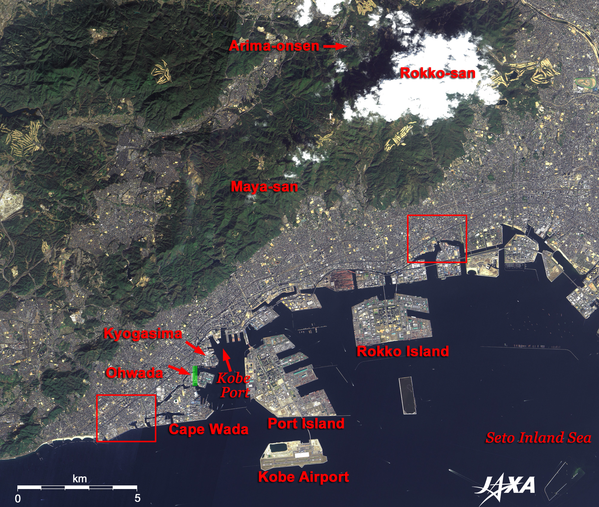
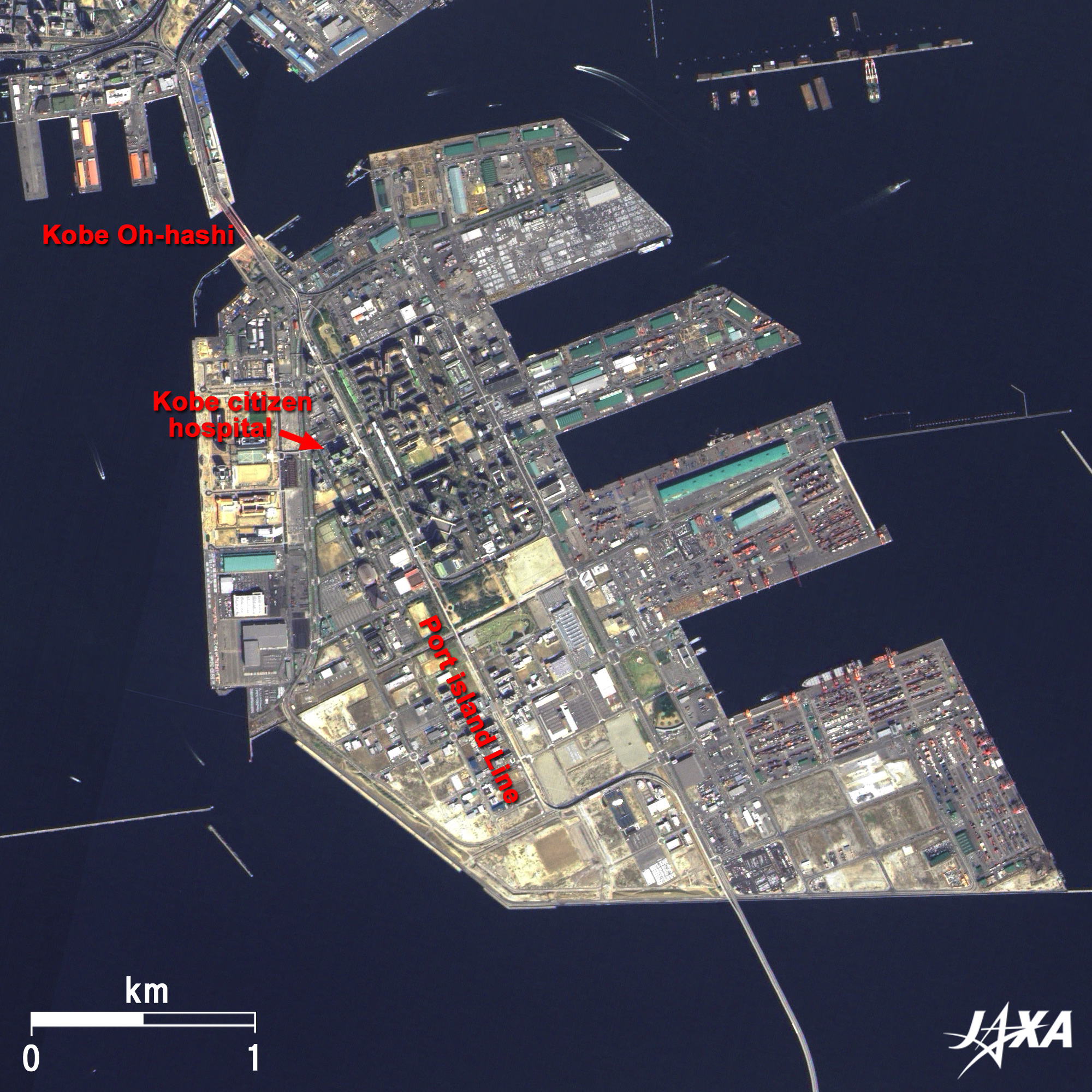
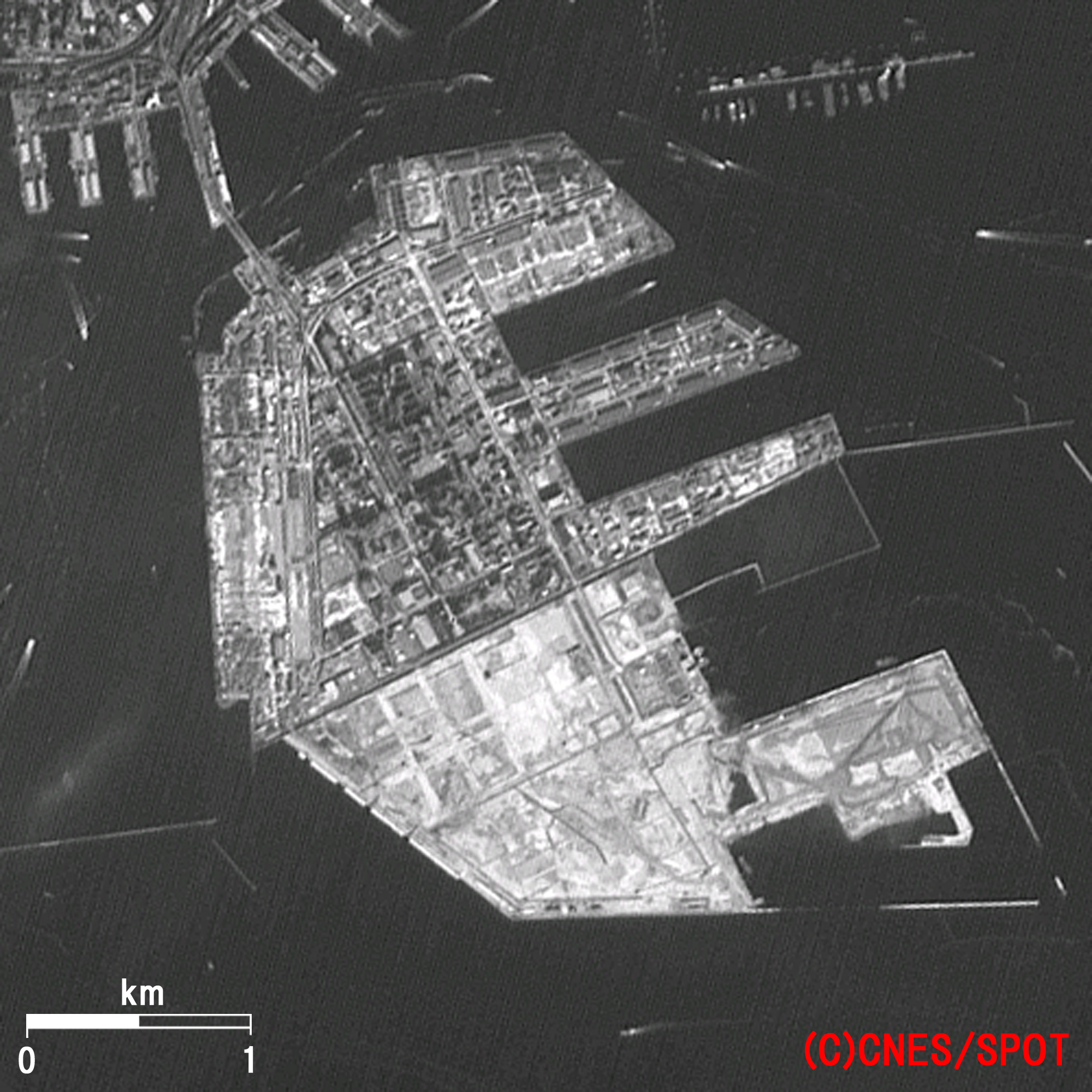
The Arima Onsen (Spring) at the foot of Mt. Rokko is very famous as one of the three oldest hot springs in Japan. Japanese warrior General Toyotomi Hideyosi (1536/37-1598), who unified Japan in that era, was very fond of Arima Onsen and visited there many times. There are many piers and much reclaimed land along the coast; Port Island and Rokko Island are the most conspicuous.

Port Island, an artificial island completed under the first construction plan in 1981, is home to the Kobe Citizen Hospital, which serves citizens in the area, and supports general city functions. Port pier '81 Exhibition was held here in 1981. Port Island connects with central Kobe via the Kobe Great Bridge and the Tsusima tunnel, as well as the Sin Kotsu Port Island Line, which opened in 2006.

Rokko Island is also an artificial island and hosts a town called Kouyou. The reclamation project was finally completed in 1993, and the first residential area was developed in March 1988; since then, many people have moved into the area. Facilities for city functions are still being developed. A reclamation project has been underway to the south off Rokko Island since 1998 in order to provide a waste disposal area.

Oowada no Tomari had served as a natural port of Kobe since ancient times. People of that era traded with merchants on the Chinese continent and the Korean peninsula through this port.
At the height of the "Heisi prosperity," Tairano Kiyomori (1118-1181) constructed the foundation of the present international port and city. The port "Owada no Tomari," which was restored by Kiyomori (Tairano Kiyomori), is now being reclaimed and is estimated to be located in the area marked by the green line in Fig. 1. It was such a good port that ships sailing around Wada Promontory and entering the inlet are protected from the strong west wind by the promontory jutting out into the sea. The embankments on the northeast side were frequently destroyed by the flooding of old Minato River, strong winds, and waves. Kiyomori constructed a strong artificial island called "Kyougasima" on the northeast side.
Kyougasima is estimated to be located in the area indicated by the arrow in Fig. 1. After Owada no Tomari was restored, it began to serve as an international port trading with So (a dynasty on the Chinese mainland) in the Heiann era (794-1192) and with Min (another dynasty on the Chinese mainland) in the Muromachi era (1336-1573).

After the battle of Genpei (about 1185) Kobe City was devastated by continuous war. Its role as the center of sea trade was transferred to Sakai City in Osaka. Owada no Tomari was renamed "Hyougo no Tsu" in the Edo era (1603-1868), and foreign trade ended due to Japan's closed-door policy. Kobe City, however, built up its position as the kitchen for the Japanese nation and the main port for Osaka and gained importance in marine transportation as the primary port connecting Osaka and Edo (present day Tokyo) once the western route (the Japan Sea coasts - the Kanmon Straits - Osaka - Kii Peninsula - Edo) was established. The port of Kobe was reopened in 1886 after the arrival of Perry's fleet (8 July 1853).

Following that, Kobe overcame numerous hardships such as the Hansin Flood and the Pacific War and developed into a large city with a population of 1 million.

Fig. 2. Close-up image of Nagata-ku in Kobe City
The Hansin Awaji Earthquake (Magnitude: 7.3) struck Kobe at 5:46am 17 January 1995 and inflicted great damage there. Sixty-seven thousand houses were completely destroyed and 6,900 were completely burned. Fire damage in Kobe's Nagata-ku was serious, and a firestorm developed just after the earthquake. The firestorm consumed house after house, eventually burning down more than 6,000 homes. Burned areas are indicted by the ellipses in Fig. 2. Figure 2 depicts the status of rebuilding just after the earthquake. The area has clearly not been restored to its former state, and there is still much vacant land.

Fig. 3. Close-up of Higashinada-ku in Kobe City
Transportation routes such as the Shinkansen (Bullet Train), JR (Japan Railway), private railroads, subways, and the Hansin Highway were cut in 51 places, and it became very difficult to transport relief goods and people. Destroyed sections of the Hansin Highway Kobe Line, up to 600m in length, were featured on the front pages of newspapers all over the world. (The green line in Fig. 3 indicates the destroyed section.)

Fig. 4. Close-up of the damaged area as it appears today (left) and on 20 Jan. 1995 just after the earthquake (right)
The Port of Kobe was heavily damaged, and almost none of the container berths and quays in the port were available. Liquefaction, in which the land surface becomes very soft, occurred primarily on reclaimed land such as Rokko Island and Port Island. Thus, support from the sea side became very difficult.

Figure 4 compares images of the vicinity of Port Island acquired at the beginning of this year (2007; left) and just after the earthquake (right) . It is estimated that liquefaction occurred in the white parts of the image just after the earthquake.

It took around three years to restore all railways and roads and two years to restore the main port facilities.

The Kobe airport (Marin Air) opened in 2006 and an integrated sea, land and air transportation system was established. Kobe City, which inherited the enterprising spirit from Tairano Kiyomori, overcame most of the great damage inflicted by the Hansin Awaji Earthquake itself and is now developing as one of Japan's most attractive cities.


Explanation of the Images:
Figs. 1 to 3 and 4 (left) -Click the images twice to enlarge them.
Satellite: Advanced Land-Observing Satellite (ALOS) (Daichi)
Sensor: Panchromatic Remote-sensing Instrument for Stereo Mapping (PRISM) , Advanced Visible and Near Infrared Radiometer-2 (AVNIR-2)
Date: 0152 (UTC) on Jan 12, 2007 (PRISM)
0152 (UTC) on Feb 27, 2007 (PRISM)
0152 (UTC) on Feb 27, 2007 (AVNIR-2)
Ground resolution: 2.5m (PRISM) and 10m (AVNIR-2)
Map Projection: Universal Transversal Mercator (UTM)
PRISM is an optical sensor for observing ground surfaces with visible and near-infrared signals in the 520 to 770 nano-meter (one-billionth of a meter) band. The acquired image is monochrome. PRISM has three independent optical systems (telescopes) to acquire images for nadir, forward, and backward views at the same time. Only the nadir image was used in this article.
AVNIR-2 is equipped with a pointing function by which it can shift its observation area perpendicular to ALOS's direction of travel and has four observation bands. The composite images are usually produced by assigning red to Band 3 (610 to 690nm), green to Band 2 (520 to 600nm), and blue to Band 1 (420 to 500nm). The AVNIR-2 composite image was then transformed into hue, saturation and intensity, and the intensity was replaced by the PRISM image. The hue, saturation and intensity data were then reversed into a color image. As a result, a virtual 2.5m ground-resolution color image was obtained. This kind of high-resolution color image, composed by combining the higher-resolution monochrome image and the lower-resolution color image, is called a pan-sharpened image.
Figures 1 to 3 and 4 (left) are high-resolution, pan-sharpened images composed this way. The resulting image has natural coloring as if seen by the naked eye. Thus, colors indicate the following ground objects.

Khaki or brown: Bare ground
Green: Forests
Bluish grey: City area or roads
Dark Blue: Water surfaces
White: Clouds

Figs. 1 to 3. and 4 (left)
Satellite: SPOT (CNES)
Sensor: HRV (High-Resolution Visible Imaging System) (Panchromatic)
Date: Jan. 20, 1995
Ground resolution: 10m
Map Projection: Universal Transversal Mercator (UTM)
HRV is an optical sensor with one visible band (510 to 730nm)
The image captured by the sensor is monochrome.
The slant observation from the right on the orbit is available. This image was acquired at a slant angle of 22 deg toward the east.

Related Sites:
ALOS Research and Application Page
Osaka: Scenes of Offshore Airports and Ancient Tombs
Harbor City, Yokohama: From the time of cultural enlightenment to "Minato Mirai 21"
Land, Seen from Space
本文ここまで。
image:Satellite Navigator
image:Satellite Applications and Operations Center(SAOC)
Earth Data Collection by JAXA Satellites
image:ページTOP