| |
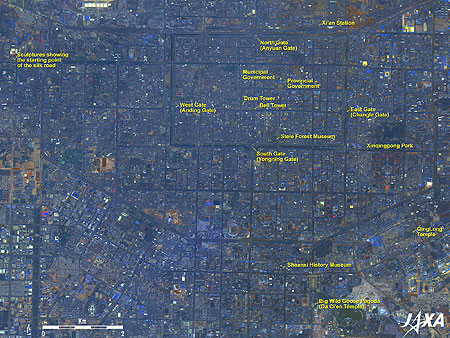 |
Fig. 1. Central Xi’an
Xi’an (kmz, 4.13MB, Low Resolution) as seen on Google Earth. |
Figure 1 is a pan-sharpened image of Xi'an, the capital of Shaanxi Province, China, acquired by the Advanced Land Observing Satellite "Daichi" in April, June and November 2007. Roads generally extend like a lattice in the north-south and east-west directions. The coverage of Fig. 1 roughly corresponds to the coverage of the Chang'an castle, the capital of the Sui dynasty (581 to 618) and the Tang dynasty (618 to 907), which was 9.7km in the east-west direction and 8.6km in the north-south direction.
You can see the rectangular streets surrounded by the moat in the upper half of the figure. The rectangle formed by this moat is 4.4km long in the east-west direction and 2.8km long in the north-south direction. Inside this moat, 15 to 18m-thick city walls can be found. The interior area of this city wall roughly corresponds to the Chang'an castle of the Sui and Tang dynasties. The present 12m-high city walls were constructed based on the 6m-thick castle walls of the Tang dynasty by accumulating bricks in the 14th century during the Ming dynasty. They are the only existing city walls that completely retain the old shapes in China. The walls have the east gate (Changle gate), the west gate (Anding gate), the south gate (Yongning gate), and the north gate (Anyuan gate), and each gate has some buildings such as watchtowers.
Within the city walls are the buildings of the Shaanxi Provincial Government and the Xi'an Municipal Government, the Bell Tower and the Drum Tower built in the 14th century, and thick roads extending from the Bell Tower to the east, west, south and north gates. The Stele Forest Museum, called the treasure house of Chinese calligraphy, near the south gate, houses more than 80,000 cultural assets including more than 3,000 stone monuments from the Han dynasty to the Qing dynasty. Almost all the copies of Japanese calligraphy are engraved prints acquired from here.
The lattice-shaped streets extend even beyond the city walls, and a wide ring road can be seen 2 to 3km outside of the circumvallation.
Sculptures indicating the starting point of the Silk Road stand at the end of the upper left of the figure.
The Shaanxi History Museum, which holds some 370,000 cultural assets from prehistoric times to the Qing dynasty, is located south of the South gate. To the southeast of the museum is the Big Wild Goose Pagoda in the Da Ci'en Temple complex. The pagoda was erected in 652 to house the many Sanskrit Buddhist scriptures, Buddhist images, and similar items that Chinese Buddhist monk Xuanzang (602 to 664) brought back from India.
Near the east gate is Xinqinggong Park, which was built at the site of Xinqinggong, a palace in the Tang dynasty, and there is a monument to Abe-no-Nakamaro (698 to 770) who was sent as the Japanese envoy to the Tang dynasty in China.
The QingLong Temple in the lower right of the figure is the where Japanese priest Kukai (774 to 835) learned the tenets of esoteric Buddhism.
Japan's Heijo-kyo Capital in the 8th century and the Heian-kyo Capital from the end of the 8th century to the 10th century were patterned after Chang'an castle in the Sui and the Tang dynasties; the major difference being that Heijo-kyo and Heian-kyo Capitals had no circumvallation.
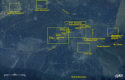 |
| Fig. 2. Wide Area Image of Xi’an |
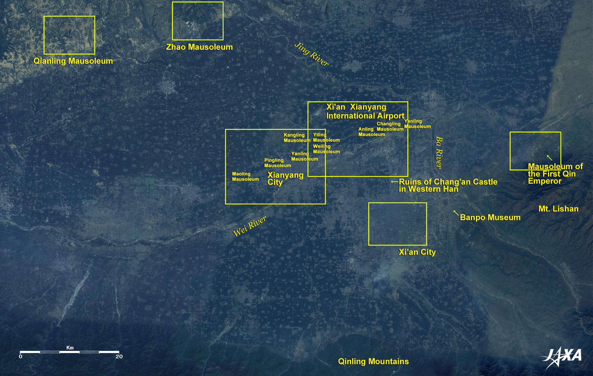
Figure 2 presents a wide-area image of Xi'an acquired by the Advanced Land Observing Satellite "Daichi" in April, September and November 2007. The innumerable gray points dotting the thick green flat area in the major part of the figure indicate villages among the farmlands.
Xi'an is defended by the Wei River, a branch of the Huang River, in the north and by the Qinling Mountains in the south. Xi'an was formerly called Chang'an (meaning "ever-lasting peace") and served as the capital of many dynasties from the Western (Former) Han dynasty (206 BC to 8 AD) until the Tang dynasty. The ruins of Chang'an (castle) in the Western Han dynasty are several kilometers northwest of downtown Xi'an and appear as green areas.
Banpo Museum, where village ruins dating back about 6,000 years (the Neolithic era) were excavated, is located in the suburbs east of Xi'an, and the Mausoleum of the First Qin Emperor is found northeast of Banpo Museum.
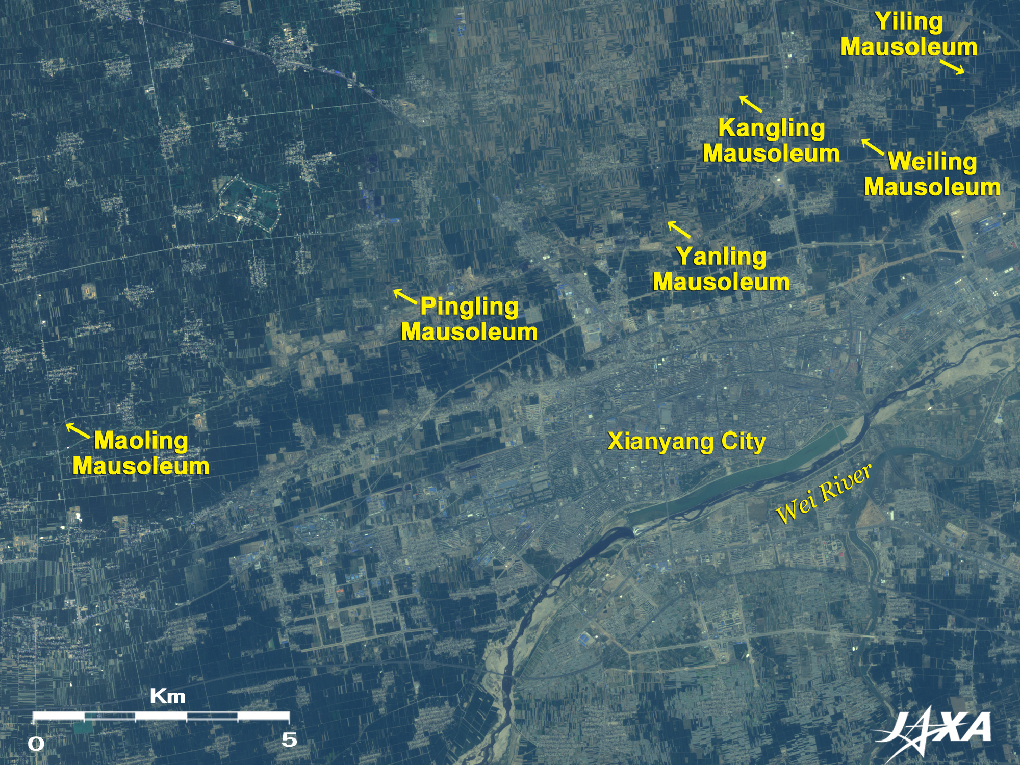
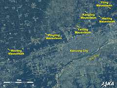
Xianyang, the Qin dynasty's (unified China in 221 BC; ended in 206 BC) capital, was established on the northern bank of the Wei River northwest of Xi'an, and the Xi'an Xianyang International Airport can be seen north of Xianyang. Additionally, the Imperial mausoleums of the emperors in the Western Han dynasty stand in a line of over 40km on the northern bank of the Wei River.
Imperial mausoleums of the emperors in the Tang dynasty can be seen in the upper left of the figure.
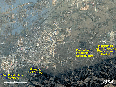 |
| Fig. 3. Mausoleum of the First Qin Emperor |
The Mausoleum of the First Qin Emperor (Qin Shi Huang, 259 BC to 210 BC), who established the first unified dynasty in China in 221 BC, is the grey-green pyramid in the right of the figure. The base of the pyramid is 375m in both east-west and north-south directions. East of the mausoleum, you can see the semi-cylindrical roof of No. 1 Pit of the Museum of Qin Terra-cotta Warriors and Horses, where thousands of standing terra-cotta figures of life-sized soldiers and horses were excavated.
The "Mausoleum of the First Qin Emperor" was added to the World Heritage list of the United Nations Educational, Scientific and Cultural Organization (UNESCO) in 1987.
Huaqing Hot Spring with its scenic beauty lies at the foot of Mt. Lishan on the left side of the figure. The sixth Emperor Xuanzong (685 to 762) in the Tang dynasty spent a lot of time here with his concubine Yang Guifei (719 to 756).
 |
 |
| Fig. 4. Imperial Mausoleums in Qianhan (West) |
Fig. 5. Imperial Mausoleums in Qianhan (East) |
The Imperial mausoleums of the emperors in the Western Han dynasty are aligned along the northern bank of the Wei River. They are, from the west, Maoling Mausoleum of Emperor Wudi (156 BC to 87 BC), Pingling Mausoleum of Emperor Zhaodi (95 BC to 74 BC), Yanling Mausoleum of Emperor Chengdi (51 BC to 7 BC), Kangling Mausoleum of Emperor Pingdi (9 BC to 5 AD), Weiling Mausoleum of Yuandi (76 BC to 33 BC), Yiling Mausoleum of Aidi (27 BC to 1 BC), Anling Mausoleum of Huidi (213 BC to 188 BC), Changling Mausoleum of Emperor Gaozu (personal name is Liu Bang; 247 BC to 195 BC), and Yanling Mausoleum of Jingdi (188 BC to 141 BC).
Expanded images reveal that every mausoleum is shaped like a pyramid, the largest of which is the Maoling Mausoleum with a base of 250m in both of east-west and north-south directions. The tops of Yanling Mausoleum and Yiling Mausoleum are shaped like plateaus.
 |
| Fig. 6. Zhao Mausoleum |
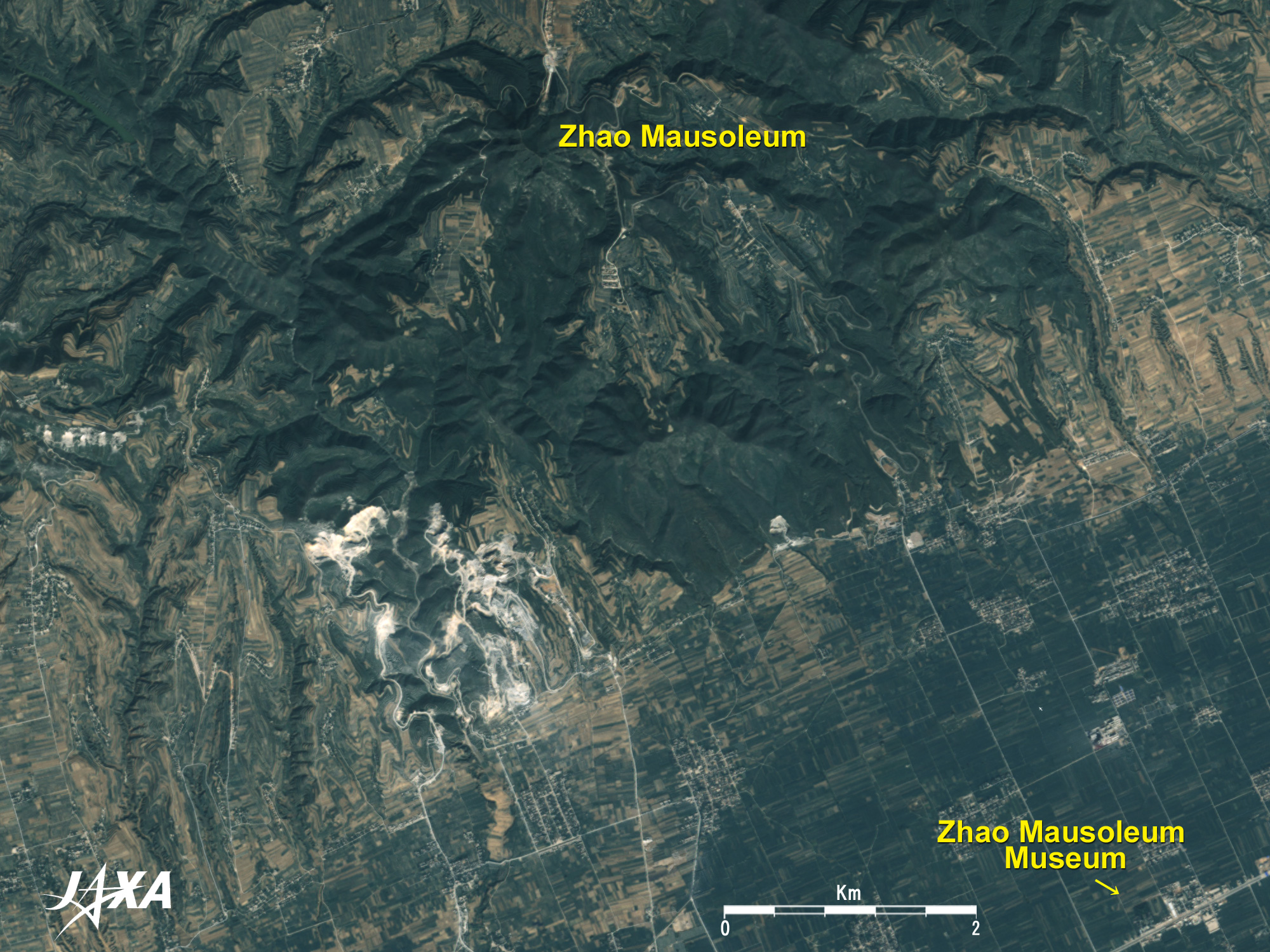
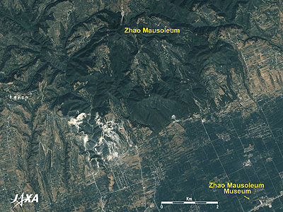
Zhao Mausoleum, the imperial mausoleum of the Tang dynasty's second Emperor Taizong (599 to 649), appears in the top of the figure. The tomb chamber and the basement palace were dug at the mountaintop of scenic Mt. Jiuzong, and the whole mountain constitutes the mausoleum. Zhao Mausoleum Museum can be seen in the lower right of the figure.
 |
| Fig. 7. Qianling Mausoleum |
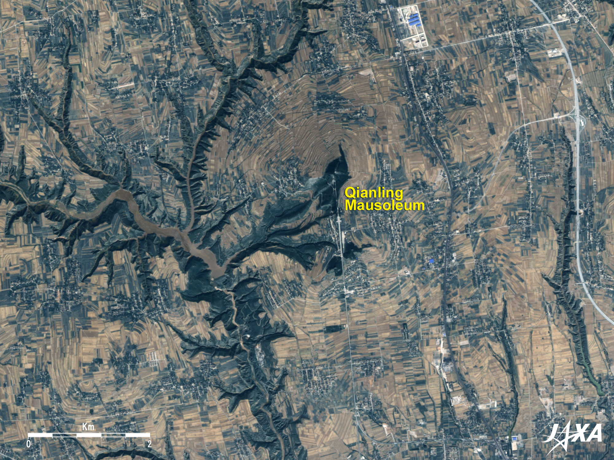
The Qianling Mausoleum is the mausoleum of the Tang dynasty’s third Emperor Gaozong (628 to -683) and his wife Wu Zetian (624 to 705) who was the only empress in China. Tomb chambers and a underground palace in the mountaintop in thick green Mt. Liangshan (1,048m above sea level) can be seen in the center of the figure, and the whole Mt. Liangshan constitutes the mausoleum as well. You can see that the approach to the mausoleum extends over 1,400m from the southern foot.
The mausoleum is surrounded by terraced fields that look like tree rings. On the west side of the mausoleum is a complicated ramifying deep ravine and a dam reservoir formed by utilizing the landform.
Reference Site:
 Homepage of the tourism administration of Xi'an Homepage of the tourism administration of Xi'an
Explanation of the Images:
(Click the images twice to enlarge.)
Figs. 1, 3, 6 and 7
PRISM is an optical sensor for observing ground surfaces at visible and near-infrared wavelengths in the 520 to 770 nano-meter (one-billionth of a meter) band. The acquired image is monochrome. PRISM has three independent optical systems (telescopes) to acquire images for nadir, forward, and backward views at the same time. Only the nadir images were used in this article.
First, an AVNIR-2 composite image was produced by assigning red to Band 3 (610 to 690nm), green to Band 2 (520 to 600nm), and blue to Band 1 (420 to 500nm). This image was then transformed into hue, saturation and intensity, and the intensity was replaced by the PRISM image. The hue, saturation and intensity data were then reversed into a color image. The result was a virtual 2.5m-ground-resolution color image. This kind of high-resolution color image, composed by combining the higher-resolution monochrome image and the lower-resolution color image, is called a pan-sharpened image.
Figures 1, 3, 6 and 7 present high-resolution, pan-sharpened images composed this way. The resulting images have natural coloring as if seen by the naked eye. Thus, colors represent the same features as in the following AVNIR-2 image. In order to cover a wider area, the ground resolution of Fig. 1 was reduced to 5.625m and those of Figs. 3, 6 and 7, to 5m.
Figs. 2, 4 and 5
AVNIR-2 has four observation bands. These figures were made by overlaying three images acquired on different days after color-composing by assigning red to visible Band 3 (610 to 690nm), green to visible Band 2 (520 to 600nm), and blue to visible Band 1 (420 to 500nm). The resulting image has natural coloring as if seen by the naked eye. Thus, colors indicate the following ground objects.
| Green: |
Forests |
| Light green: |
Grass or farmland |
| Grey: |
City area or roads |
| Blue: |
Water area |
|
|