| |
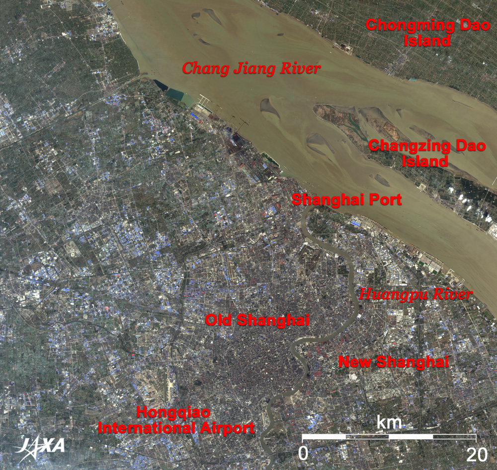
Figure 1 depicts the vicinity of Shanghai as observed by the Advanced Visible and Near Infrared Radiometer-2 (AVNIR-2) on board the Advanced Land Observing Satellite (ALOS) "Daichi" in February 2007. The large river in the upper part of the figure is Chang Jiang River (upstream name, Jinsha River; downstream name, Yantze River). Chang Jiang River is the longest river in Asia (6,300km). It originates in the Tibetan Plateau and pours into the East China Sea. ALOS just captured the mouth of this great river. The brownish muddy water indicates that the river is affluent and rich with sediment carried from the long watershed in central China (mid- and downstream area of Chang Jiang River).
Extending along the southern bank of the river is the city of Shanghai, the largest city in China with a huge population of 20 million and located 1,070km south-southeast from the capital Beijing. Huangpu River, meandering through the city from south to north, joins Chang Jiang River. The old Shanghai is on the west side of the river, and the new Shanghai is on the east side. Shanghai's port is the largest river port in China. It developed at the mouth of Chang Jiang River and on both banks of the Huangpu River. Many piers and wharfs can be seen on the riverbank. Chongming Dao Island (twice as large as Japan's Awaji Island) and Changzing Dao Island, located at the mouth of Chang Jiang River, are formed by sediment and provide rich natural environments for the citizens of Shanghai. A runway of the Hongqiao International Airport is visible in the lower part of the figure.
 |
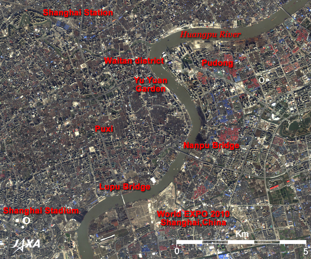
Fig. 2 Close-up of the central part of Shanghai
Shanghai (kmz,1.76MB,Low Resolution) is seen from Google Earth. |
Figure 2 presents a close-up image of central Shanghai. The west bank of Huangpu River is called Puxi, and the east bank is called Pudong. Waitan district (the Bund) in Puxi, which stretches north and south along the bank of the Huangpu River, is famous for beautiful stone buildings dating from the 1920s. The Pudong district on the opposite bank is a new town developed after the reform and opening-up in the 1990s and is developing as a business area with the world's tallest hotels, crowned by the 468m-high Oriental Pearl Tower (Dongfang Mingzhuta TV tower), the symbol of the new Shanghai. Its contrast to the historic Waitan district sharply contrasts the present and past of Shanghai. These neo-futuristic skyscrapers cast their long shadows toward the northwest (see the enlarged image of Fig. 2). The TV tower's shadow extends to the middle of the river. Construction of Shanghai Hills (Shanghai World Financial Center, 101 stories above the ground, 492m high), which belong to the same business group as Roppongi Hills in Tokyo, will be completed in 2008. The venue of World EXPO 2010, Shanghai, China, straddles the Huangpu River between Nanpu Bridge and Lupu Bridge. In particular, the bright bare land in the theme pavilion construction site in Pudong district indicates that construction is steadily progressing. Nanpu Bridge has a similar loop structure like Rainbow Bridge in Tokyo. Additionally, the renowned Yu Yuan Garden of the Ming Dynasty, Shanghai Stadium for football game of the XXIX Olympiad Beijing 2008, and Shanghai Station, the key station for local cities, are visible in the Puxi area. Scattered red or blue areas in the city indicate roofs of housing complexes.
Shanghai is located on the southern bank of Chang Jiang River, which was used as a main traffic route of the water-surface trade in the Central China and opens to the sea. Taking advantage of these geographical features, Shanghai has developed as a harbor city since the 13th century. Settlements of western countries were established there in the early 20th century, and Shanghai became an international city. In the 21st century, Shanghai is deepening its relationships with foreign countries, including Japan, as a major business center of international trade, finance, and economy. Looking back on Japan's growth stimulated by hosting the Tokyo Olympics (1964) and the Osaka Expo (1970) some 40 years ago and subsequent rapid economic development, we can say that Shanghai is now the most dynamic city in China, which is hosting the Beijing Olympics and the Shanghai Expo.
Explanation of the Images:
Fig. 1, Fig. 2 and the full image
AVNIR-2 has four observation bands. The composite images (Fig. 1, Fig. 2 and the full image) are produced by assigning red to Band 3 (610 to 690 nm), green to Band 2 (520 to 600 nm), and blue to Band 1 (420 to 500nm). The resulting image has natural coloring as if seen by the naked eye. Thus, the ground objects are distinguished by the following colors.
| Green: |
Forests, grass fields, farms |
| Ocher: |
Farms, bare lands, rivers, sea |
| Bluish grey |
City area or roads |
| Red, blue: |
Roofs |
| White: |
Clouds |
| Black: |
Shade of cloud or building, area with no data |
|
 |
|