| |
 |
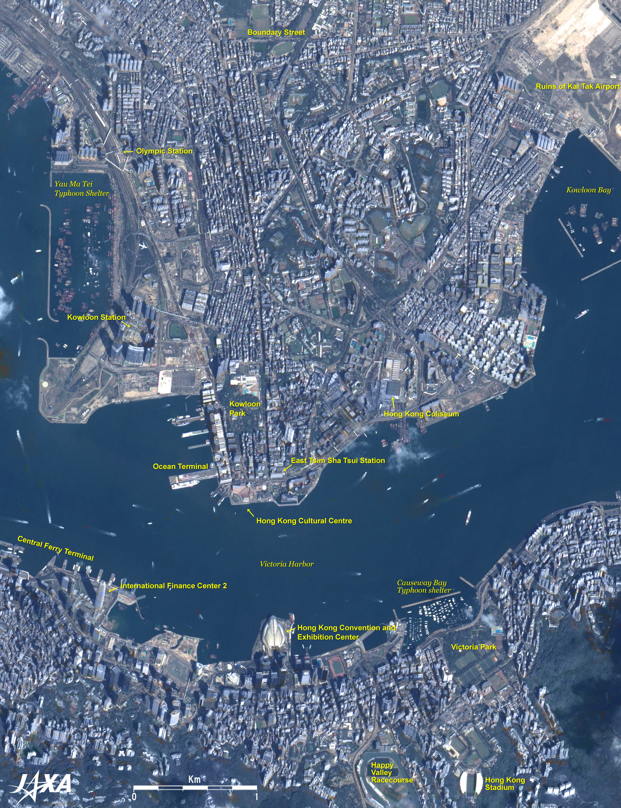
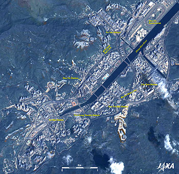
Fig. 1. Central Hong Kong
Hong Kong (kmz, 5.29MB, Low Resolution) as seen on Google Earth. |
Figure 1 presents a pan-sharpened image of Hong Kong acquired by the Advanced Land Observing Satellite "Daichi" in October 2007. The figure presents a solid pattern of the southern flank of the buildings because it was composed of the backward-looking image of PRISM aboard Daichi. There are forests of countless buildings including skyscrapers, and many ships and boats anchored or sailing in the adjacent sea.
The center of the figure depicts Victoria Harbor; the south side is Hong Kong Island, and the north side is Kowloon. This area in Hong Kong Island is the center of public administration, culture and finance in Hong Kong. On the west side, the Central Ferry Terminal and the International Finance Center 2, which, at 420m in height, is Hong Kong's tallest building with 88 floors, can be seen. The Hong Kong Convention and Exhibition Center is in the center; the Happy Valley Racecourse, the Hong Kong Stadium, and Victoria Park are on the east side.
Along the west coast of Kowloon, the Mass Transit Railway's (MTR's) Airport Express and Tung Chung Line run parallel, and there are high-rise, multifamily housing around Kowloon Station and Olympic Station of the two lines. North of Kowloon Station you can see a jet plane that was accidentally captured in flight. The southern tip of Kowloon Peninsula is a shopping area with many shops and restaurants. Kowloon Park, East Tsim Sha Tsui Station (a terminal of the East Rail Line), the Hong Kong Cultural Center, and the Hong Kong Coliseum are visible.
In the upper right of the figure, you can see the ruins of Kai Tak Airport that was used until July 5, 1998. The airport was famous for the difficulties of landing from the northwest direction after skimming building tops in Kowloon district.
The 3-km-long Boundary Street can be seen extending east to west in the upper part of the figure. It had been the boundary between Hong Kong and China (Qing Dynasty) since 1860.
 |
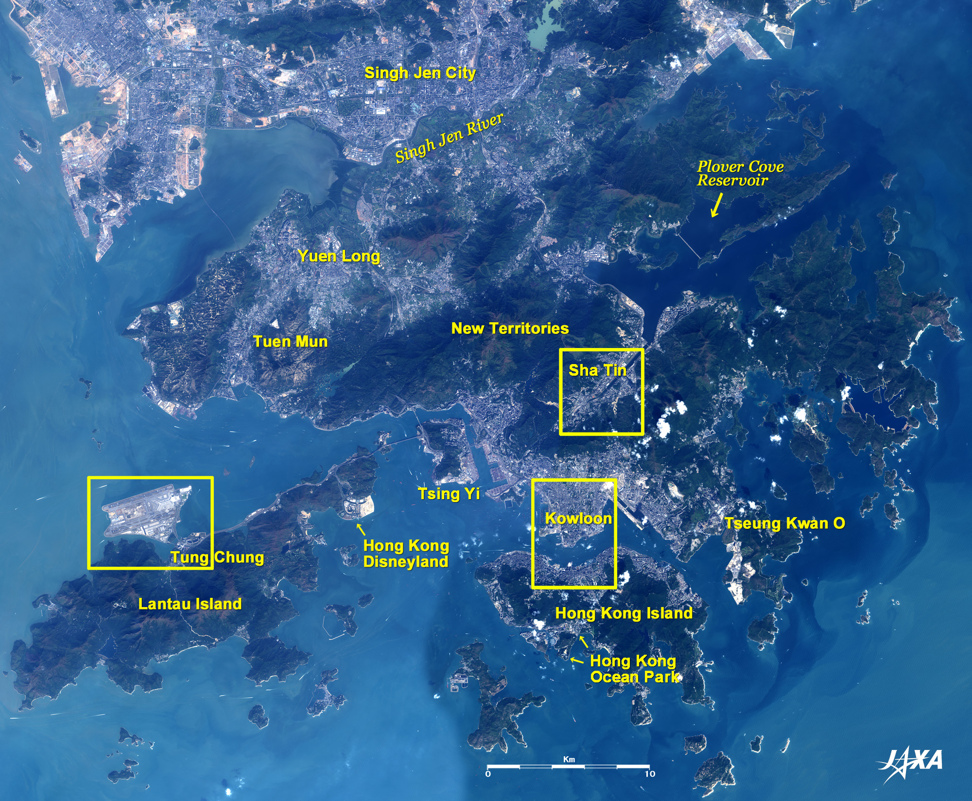
| Fig. 2. Wide Area Image of Hong Kong |
Figure 2 is a wide area image of Hong Kong acquired by the Advanced Land Observing Satellite Daichi in the fall of 2007. The Hong Kong Special Administrative Region, which the United Kingdom returned to China on July 1, 1997, consists of Hong Kong Island in the bottom of the figure, Kowloon in the center, and the New Territories (leased since 1898) in the upper part. Lantau Island in the lower left is included in the New Territories. The north side of Singh Jen River (top of the figure) is a part of the Chinese mainland, and the city area of Singh Jen city, a special economic zone, can be seen.
In the Hong Kong Special Administrative Region, 7 million people live in a 1,100 sq km area, making it the world's most densely populated area (density 6,400 /km2). As shown in the figure, the greater part of Hong Kong is the upland covered with thick green vegetation, and flat areas suitable for house building are limited. Therefore, new towns containing super high-rise multifamily housing have been constructed in the suburbs such as Sha Tin, Yuen Long, Tuen Mun, Tseung Kwan O, Tsing Yi and Lantau Island's Tung Chung, in addition to the major areas, Kowloon and Hong Kong Island together with infrastructure such as railroads and expressways.
Hong Kong Disneyland, which opened as the 5th Disney Resort in the world in September 2005, can be seen on the landfill in the eastern area of Lantau Island. You can observe a yellowish-white landfill area of approximately the same size east of Disneyland, indicating that the expansion project is moving ahead.
Hong Kong Ocean Park, a leisure facility opened in January 1977, is located on southwestern Hong Kong Island.
The Plover Cove Reservoir, which was partitioned on the 2.1km long white bank, can be seen in the upper right of the figure. This reservoir was completed in 1968 in response to a water shortage in the 1960s. Following that, additional construction to raise the bank resulted in the present reservoir capacity of 230 million m3 of water.
 |
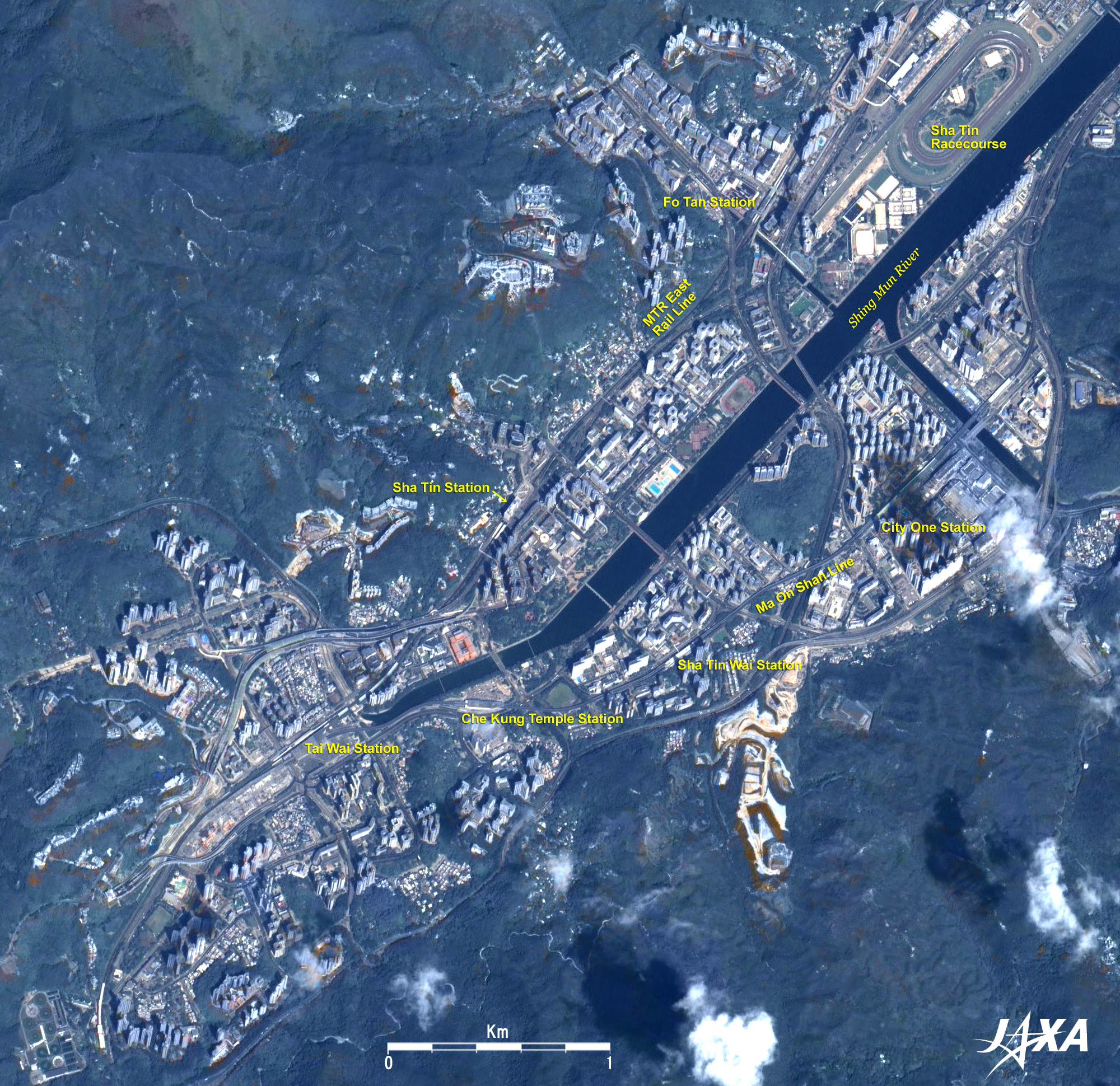
| Fig. 3. Huge Housing Complex in Sha Tin, suburb of Hong Kong |
Sha Tin is one of the areas developed as part of the new town construction project by the Hong Kong Government Office in order to cope with population growth. A large-scale reclamation project was implemented on the inlet in the 1970s, and numerous high-rise multifamily housing buildings have been constructed on both sides of the channel (called "Shing Mun River") since the 1980s. At the same time, the Kowloon-Canton Railway (present MTR East Rail Line) on the west coast of the channel was electrified, and the Ma On Shan Line was opened on the eastern coast in 2004. You can also see the web of expressways developed in the same way.
The Sha Tin Racecourse is visible in the upper right of the figure. There is a plan to use it as the main stadium for the equestrian events of the Beijing Olympic Games (to be held in August 2008) because the isolation period when importing live animals into Hong Kong is shorter than that in the Chinese mainland due to the difference in the respective quarantine systems, and because they can easily prepare facilities where the quarantined horses can exercise during the isolation period.
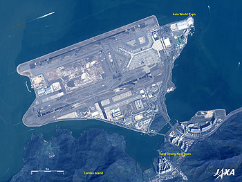 |
| Fig. 4. Hong Kong International Airport |
Figure 4 presents an image of Hong Kong International Airport (Chek Lap Kok Airport), which was opened on July 6, 1998. The previous Kai Tak Airport, which was depicted in Fig. 1, reached its maximum take-off and landing capacity in the late 1980s. There was no room for additional construction, so in 1992 it was decided to construct a new airport. When construction was completed on an artificial island incorporating Chek Lap Kok Island off Lantau Island, Hong Kong International Airport was capable of supporting around-the-clock take-offs and landings. Two parallel 3,800m-long runways, a terminal building with its white-and-gray-striped roof, many parked aircraft, and other airport facilities can be seen. At the northeast end of the airport is the Asia World Expo with Hong Kong's largest display space (70,000m2). The Airport Express rail line runs about 35km between the Airport Station and Hong Kong Station in northern Hong Kong Island together with an expressway.
You can find a new town with super high-rise multifamily apartments in the Tung Chung area corresponding to the base of the airport island.
Explanation of the Images:
Figs. 1 to 4 - Click the images twice to enlarge them.
Figs. 1, 3 and 4
PRISM is an optical sensor for observing ground surfaces at visible and near-infrared wavelengths in the 520 to 770 nano-meter (one-billionth of a meter) band. The acquired image is monochrome. PRISM has three independent optical systems (telescopes) to acquire images for nadir, forward, and backward views at the same time. Only the backward images were used in this article.
First, an AVNIR-2 composite image was produced by assigning red to Band 3 (610 to 690nm), green to Band 2 (520 to 600nm), and blue to Band 1 (420 to 500nm). This image was then transformed into hue, saturation and intensity, and the intensity was replaced by the PRISM image. The hue, saturation and intensity data were then reversed into a color image. The result was a virtual 2.5 m-ground-resolution color image. This kind of high-resolution color image, composed by combining the higher-resolution monochrome image and the lower-resolution color image, is called a pan-sharpened image.
Figures 1, 3 and 4 present high-resolution, pan-sharpened images composed this way. The resulting images have natural coloring as if seen by the naked eye. Thus, colors represent the same features as in the following AVNIR-2 image.
Fig. 2
AVNIR-2 has four observation bands. Figure 2 was made by sticking two images observed on different days after color-composing by assigning red to visible Band 3 (610 to 690nm), green to visible Band 2 (520 to 600nm), and blue to visible Band 1 (420 to 500nm). The resulting image has natural coloring as if seen by the naked eye. Thus, colors indicate the following ground objects.
| Green: |
Forests |
| Light green: |
Grass or farmland |
| Grey: |
City area or roads |
| Blue: |
Water area |
|
|