| |
 |
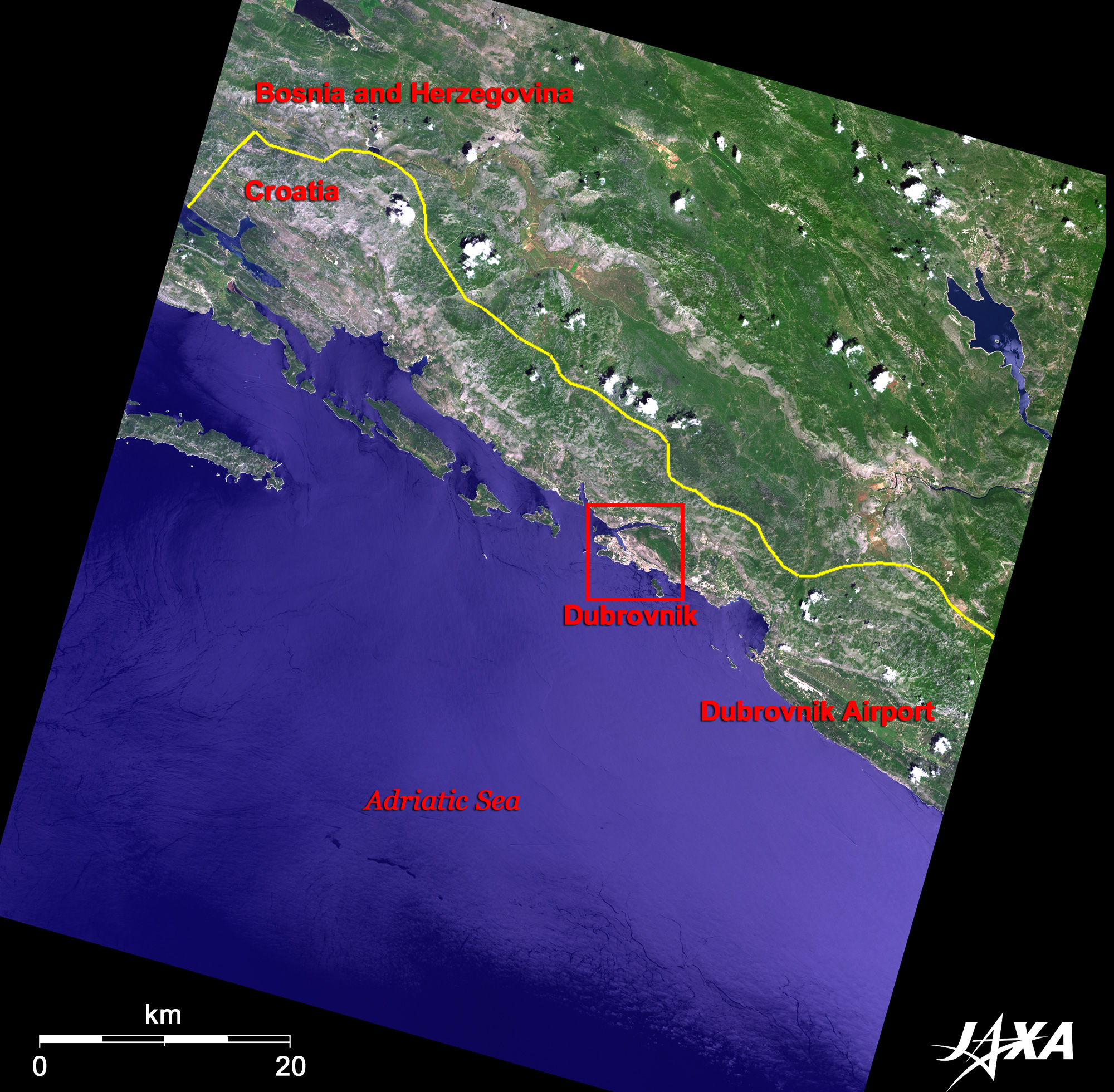
| Fig. 1. District of Dubrovnik, Southernmost End of Croatia |
Figure 1 presents an image of Dubrovnik district (Dubrovnik-Neretva County) in the southernmost end of Croatia as observed in June 2007. The area on the Adriatic Sea coast is Croatia, and the mountainous and hilly inland area is Bosnia and Herzegovina. The greater portion of Croatia extends outside toward the northwest of the image; Fig. 1. captured the extreme south of Croatia. The 7km-wide border between Croatia and Bosnia and Herzegovina reaches the sea coast in the northwestern part of the figure, which indicates that the district of Dubrovnik is an exclave of Croatia.
The Adriatic Sea coastal area including 100 to 150km inland from the coast has a karst topography consisting mostly of limestone. The many islands with exposed limestone visible along the coast are known as the Archipelago Sea. These geographical features were formed through erosion by rainwater when the sea level was low during the glacial age and became the submerged karst topography after the subsequent rise of the sea level. The sea level in the last glacial period (10,000 to 70,000 years ago) is estimated to be 125m lower than it is today. Figure 1 depicts some of these islands along the coast.
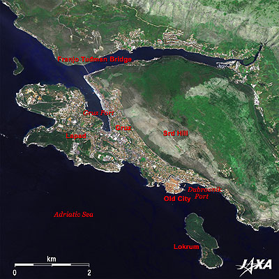 |
Fig. 2. Dubrovnik and Vicinity
Dubrovnik, Croatia (kmz, 3.96MB, Low Resolution) as seen on Google Earth. |
Figure 2 presents an image of Dubrovnik and its vicinity. The Adriatic Sea is located between the Italian Peninsula and the Balkan Peninsula. The sea coast of Croatia on the Balkan Peninsula has complex geographical features with much scenic landscape and many resorts. Some cities on the steep cliff prospered as key junctions of maritime trade from the medieval times, and today are preserved as over 400-year-old cityscapes. In particular, the "Old City of Dubrovnik" is proud of its beautiful rows of houses and is well known as the "Pearl of the Adriatic." Along with small cities such as Venice in Italy, Dubrovnik prospered as a city state and was added to the list of the World Heritage of the United Nations Educational, Scientific and Cultural Organization (UNESCO) in 1979. However, the town was badly damaged during the civil war and was placed on "The Heritage in Danger" list from 1991 to 1998.
Dubrovnik consists of an old city projecting to the Adriatic Sea and a new city that spreads across the slope of Srd Hill (altitude 412m). Orange-colored brick houses, surrounded by city walls, cluster in the old city. Although there is no railroad station in Dubrovnik, the city transportation network by bus and marine traffic between nearby islands using ferry or liner is well developed. A bus terminal and a sea port are located in the Gruz (GruE area on the left of the figure. The recently built Bridge of Franjo Tudman has greatly shortened the route from Dubrovnik to the opposite coast.
A white cross presented by Napoleon stands on Srd Hill north of Dubrovnik. Lokrum Island, about 700m southeast, is a resort with three beaches where tourists flock in summer, although it is a desert island.
 |
| Fig. 3. Vicinity of Old City of Dubrovnik |
The terra-cotta-colored area in the center of Fig. 3 is the Old City of Dubrovnik. This small town (2km in circumference) prospered as a key junction in maritime trade and retains vestiges of the 14th-century autonomous city. It has welfare facilities such as the oldest European pharmacy and orphanage, and public facilities such as a well developed water and sewage system. These are the legacies of merchants who made money from trading and invested it in the town without monopolizing the wealth.
City walls, 3 to 6m wide and up to 25m high, connect the fortresses at the corners. The main street (Placa-Stradum: Placa Street) runs east from the Pile Gate (Gradska Vrata Pile) at the west end of the wall, and narrow alleys stretch like a mesh on both sides of the street. The street is beautifully paved with marble stones and looks bright. Stepping inside the Old City from the gate, the Franciscan Monastery (Museum) is located just on the left. This is also the Pharmacy Museum and the third oldest pharmacy in Europe. It opened in 1391 and keeps more than twenty thousand gallipots and handwritten prescriptions.
The Dominican Monastery (Museum) is located on the northeastern end of the Old City. This monastery was built in the 15th century incorporating Romanesque, Gothic, and Renaissance style architectures. It is also open to the public as a religious art museum. In the southeastern part of the city, are Dubrovnik Cathedral and Treasury, which are said to have been built by the British king "Richard the Lionheart" in 1192. This baroque cathedral, rebuilt in the 17th century, keeps the city treasures, which reminds us of the days when the city prospered through trade.
The old cities that prospered along the coast were terribly damaged during the war of independence (the civil war) that broke out in 1991. The cities have now recovered from the disorder during the war and are being restored by civic efforts. Traces of the good old days are coming back.
Explanation of the Images:
(Click the images twice to enlarge.)
AVNIR-2 has four observation bands. The composite images (Figs. 1 to 3) are usually produced by assigning red to Band 3 (610 to 690nm), green to Band 2 (520 to 600nm), and blue to Band 1 (420 to 500nm). In the above figures, green is assigned to the sum of 80% of Band 2 and 20% of Band 4 (760 to 890nm), which improves the visibility of vegetation. The resulting images have natural coloring as if seen by the naked eye. Thus, the following colors designate ground objects.
| Green: |
Forests |
| Light green: |
Farmlands or grass fields |
| Grey: |
City area, roads or rock surfaces |
| Reddish brown: |
Brick houses |
| Blue: |
Water surfaces |
Figs. 2 and 3
PRISM is an optical sensor for observing ground surfaces with visible and near-infrared signals in the 520 to 770 nano-meter (one-billionth of a meter) band. The acquired image is monochrome. PRISM has three independent optical systems (telescopes) to acquire images for nadir, forward, and backward views at the same time. Only the nadir image was used in this article.
The above AVNIR-2 composite image was then transformed into hue, saturation and intensity, and the intensity was replaced by the PRISM image. The hue, saturation and intensity data were then reversed into a color image. As a result, a virtual 2.5-m ground-resolution color image was obtained. This kind of high-resolution color image, composed by combining the higher resolution monochrome image and the lower resolution color image, is called a pan-sharpened image.
|
|