Seen from Space 2008
Port Town of the Golden Sun - Naples
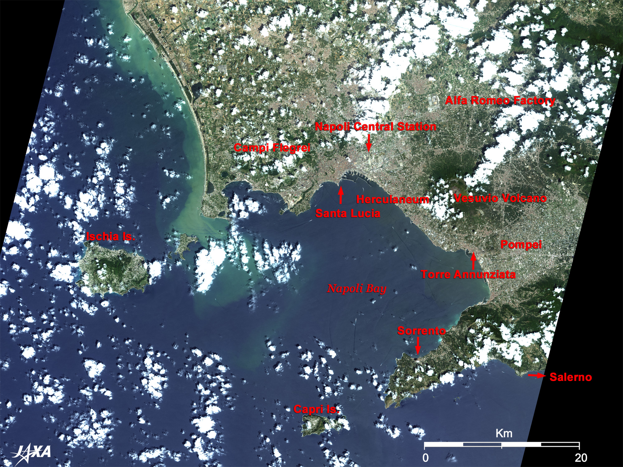
Naples is made up of the terra-cotta downtown area in the west and the grey industrial area in the east on both sides of Naples Central Station (Napoli Centrale) of the Italian railway (Trenitalia). Naples (Capodichino) International Airport is located to the north of the industrial area. Unfortunately, however, it is not visible due to cloud cover. The vast grey building complex located 13km northeast of the central station is the Alfa Romeo factory, one of Italy's leading car manufacturers. Italy is a volcanic country like Japan. Vesuvius (Vesuvio) volcano (1,281m) is seen between the clouds east of Naples, and a 13km-wide caldera called the Phlegraean Fields (Campi Flegrei) with many volcanic craters in it is visible in the west. They are now lakes and golf courses. Three World Heritage sites of the United Nations Educational, Scientific and Cultural Organization (UNESCO) are visible in the figure. The Historic Centre of Naples was added to the list in 1995, and the Archaeological Areas of Pompei, Herculaneum and Torre Annunziata and Costiera Amalfitana (Amalfi Coast) were added in 1997. The ruins of Pompeii (Ponpei) are located south of Vesuvius. Pompeii had prospered as a Roman colony since the 6th century B.C. However, on August 24, 79 A.D., there was a catastrophic eruption of Vesuvius. Pompeii was buried under many meters of ash and pumice and vanished from people's memories. The ruins were discovered in the 18th century and revealed an extraordinarily detailed cityscape of that time when excavated. Small but neatly designed drainage system than that of Pompeii and fresco paintings were found at Ercolano west of Vesuvius. Furthermore, the villa of the Emperor Nero's second wife (Empress Poppaea) was excavated at Torre Annunziata south of Vesuvius. Located to the south of Pompeii and across the Bay of Naples is the Sorrentine Peninsula renowned for the Naples folk ballad "Come Back to Sorrento" (Torna a Surriento). Sorrento is a traditional resort built on a high cliff near the tip of the peninsula. A small fishery harbor is also seen below the cliff. Terra-cotta roofs of the town are visible in the figure. The 40km-long coastline from Sorrento to Salerno is the Amalfi Coast (Costiera Amalfitana), one of the most beautiful coastlines in the world. The Island of Capri (Isola di Capri), famous for the Blue Grotto (Grotta Azzurra), is seen off the Sorrentine Peninsula. Augustus (63B.C.-14), the first emperor of the Roman Empire, exchanged his Ischia Island (isola d'Ischia, on the left of Fig. 1) for Capri and called it "the ground of sweet pleasure." Today it is a Nature Reserve (sanctuary) where rare plants, animals, and sea life coexist in peace. The Blue Grotto located below the cliff north of Capri is clearly visible without obscuring clouds.
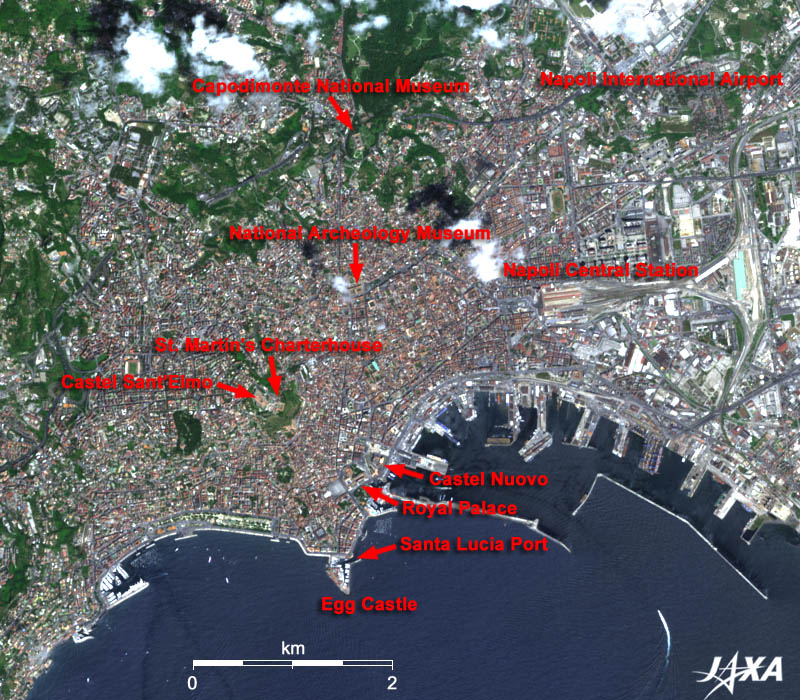
Santa Lucia was once a prosperous fishery harbor but today is lined with exclusive hotels and restaurants, which offer fine panoramic views of Vesuvius and the Bay of Naples (Golfo di Napoli). The Egg Castle (Castel dell'Ovo) is located on an islet at the tip of an inverted triangular shape jutting out into the bay. It was built by Norman kings in the 12th century and became a residence of the Anjou's king in the 13th century. The name of the castle is said to have been based on the medieval legend that a building has a permanent life when "the egg of magic" is put in a bottle and buried in the foundation. New Castle (Castel Nuovo ; named "new" to contrast it with the Egg Castle) was built as the Royal Palace of the King of Naples in the period of Spanish rule in the early 17th century, Castle Sant'Elmo on Vomero Hill looks down on the town of Naples, and St. Martin's Charterhouse (Certosa di San Martino) is now used for the national art museum. These are typical historical monuments included in the Historic Centre of Naples of the World Heritage. Naples is also called the birthplace of Italian cuisine, having given rise to pasta, pizza, and gelato. The history of pasta in Italy is very old. Tools to make pasta, quite similar to the present pasta, were found in Etruscan ruins of the 4th century B.C. in the suburbs of Rome. It was baked or fried in those days. Boiling of dried pasta like today began in the middle of the 16th century in Naples to preserve food to prepare for famine.
|