| |
 |
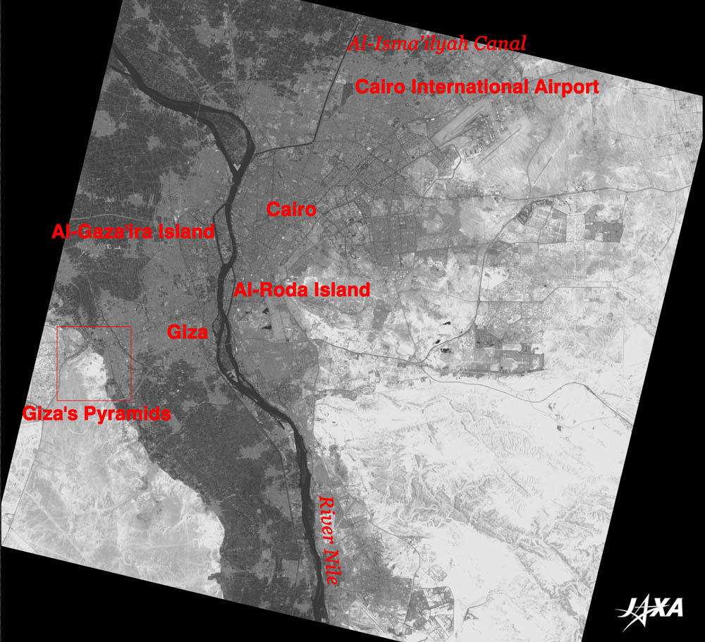
Fig. 1 Vicinity of Cairo
Cairo(kmz, 1.34MB, Low Resolution) as seen on Google Earth. |
Figure 1 depicts Cairo, Egypt, and its vicinity as observed by the Panchromatic Remote-sensing Instrument for Stereo Mapping (PRISM) on board the Advanced Land Observing Satellite (ALOS) "Daichi" in June 2006. In this monochrome image, water surfaces are black, forests or farmlands are dark grey, residential areas or urban areas are grey, and desert or dry bare land is white.
The black winding belt running from the bottom to the upper left of the image is the Nile River flowing to the north, and this area is the base of the Nile Delta. Four big holms are visible in this image. The artificial straight line stretching northeast on the east side of the northernmost holm is the Al Isma'ilyah Canal. The two holms in the middle are Al-Gaza'ira Island (upper) and Al-Roda Island (lower). Cairo's downtown extends to the east (right-hand side) of Al-Gaza'ira Island and the Nile. At the southernmost end of Al-Roda Island, there is the oldest Nilometer* now existing. On the left bank (west side) of the Nile, across the south bridge of Al-Roda Island, is the city area of Giza. The straight, black Al-Haram (Pyramid Avenue) extending to southwest is faintly visible. Located beyond that at the edge of the desert are Giza's pyramids. The pyramids are sometimes believed to stand in a vast extent of desert, but in fact they are very close to the urban area.
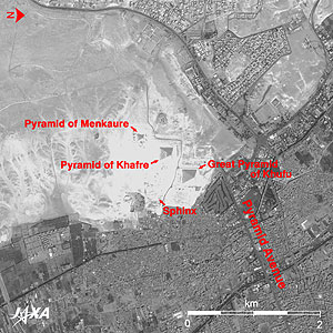 |
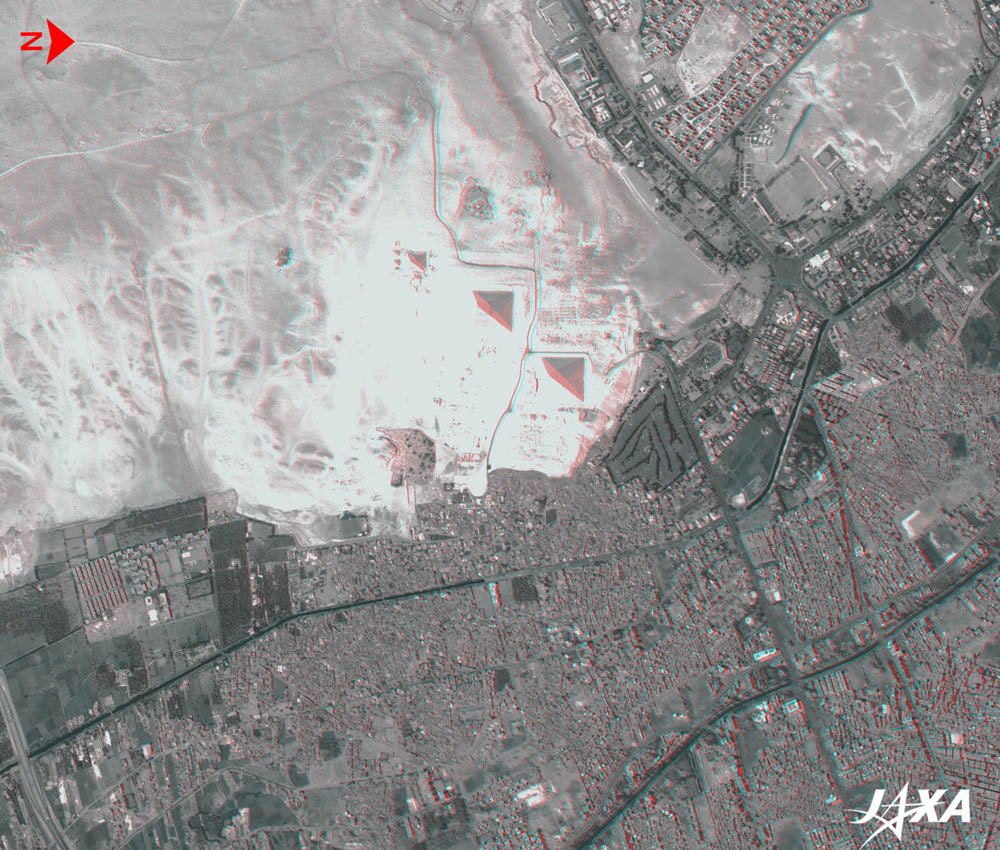
| Fig. 2 Giza's Pyramids and their Vicinity |
A tourist road connected to Pyramid Avenue runs along the west side of the Great Pyramid of Khufu and then reaches a T junction. To the left (east) at the T junction is the Sphinx, and to the right (west) along the corner of the Pyramid of Khafre is the Pyramid of Menkaure.
Originally, the Great Pyramid of Khufu was 146m tall, but the summit portion was lost and the present height is 137m. An iron bar stands at the top to indicate the original height. The surface was once covered by stones for coatings, but all coating stones have been stolen and only bare stones remain now. Smaller pyramids of queens stand to the southeast of the Pyramid of Khufu, and a cluster of tombs can be seen like boxes in grids on its east and west sides.
The Pyramid of Khafre, standing in the middle of the three pyramids, is preserved rather well with some makeup stones remaining; it is called the most beautiful pyramid in Egypt. This pyramid is 143m tall, and the Mortuary Temple is visible in the east. From where the approaching road extends toward east and beyond that is the famous Great Sphinx standing beside the Valley Temple, and its shadow is faintly visible.
The Pyramid of Menkaure is 65.5m tall, and it is accompanied by three smaller pyramids of his queens; their shadows are also visible.
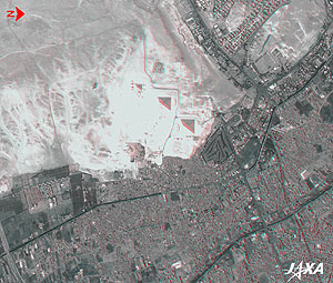 |
Fig. 3 Three-Dimensional View of Giza's Pyramids and their Vicinity
(Staring at the image for a long time may cause eye strain. A colored print is available in pdf format. Pdf files for the right and left eyes are also available.)
|
Giza's three pyramids can be enjoyed in three dimensions if they are viewed with a blue lens over the right eye and a red lens over the left eye. It might also be recognized that the pyramids stand on a slope and that the ground gradually rises to the west. In the upper right of the image, multi-family, medium-rise housing is clearly visible in three dimensions.
"Memphis and its Necropolis - the Pyramid Fields from Giza to Dahshur" including Giza's three Great Pyramids and the Great Sphinx was added to the World Heritage list of the United Nations Educational, Scientific and Cultural Organization (UNESCO) in 1979.
*The Nile caused major floods annually in old times. A gauge was installed upstream of the holm of the Nile to detect any rise in water level and was used to warn of flooding.
Reference Site:
 How to make red and blue glasses (cf. Appendix of "Three-Dimensional View of Mt. Haruna") How to make red and blue glasses (cf. Appendix of "Three-Dimensional View of Mt. Haruna")
|
Explanation of the Image:
| Satellite: |
Advanced Land-Observing Satellite (ALOS) (Daichi) |
| Sensor: |
Panchromatic Remote-sensing Instrument for Stereo Mapping (PRISM) |
| Date: |
0840 (UTC) on June 23, 2006 |
| Ground resolution |
2.5 m |
| Map Projection: |
Universal Transversal Mercator (UTM) |
| Figures 1 and 2 are back-looking images, and Fig. 3 was composed of nadir (red) and forward-looking (green and blue) images. In Fig. 3, the left side is the satellite flight direction because the nadir image of the satellite is seen with the left eye and the forward-looking image with the right eye. The left side nearly corresponds to south. Note that the right side is north in Figs. 2 and 3 even though the top is usually north in most satellite images. |
|
 |
|