| |
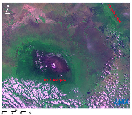 |
Fig. 1. Mt. Kilimanjaro and its vicinity observed by AVNIR-2
Kilimanjaro(kmz, 3.69MB, Low Resolution) as seen on Google Earth. |
Figure 1 depicts Mt. Kilimanjaro (5,895m above sea level) and vicinity as observed by the Advanced Visible and Near-Infrared Radiometer 2 (AVNIR-2) aboard the Advanced Land Observing Satellite (ALOS) "Daichi" in June 2006. Mt. Kilimanjaro is left of center of the image with the Chuyulu Range in the upper right. Lower portions and portions to the right in the image were dotted with clouds. On the top of Mt. Kilimanjaro, snow and ice fields (or glaciers) look white or light purple. The exposed rock surface appears claret; grassland, blue-purple or dark-brown; forest (or jungle), dark green, grassland, light green; and sparse vegetation areas (savannah), hazel. Each sits in the circle of the ellipse and surrounds the summit. This is because Mt. Kilimanjaro is an independent peak with a variety of climatic zones existing between the mountaintop and the foot of the mountain about 1,000 m above sea level.
Mt. Kilimanjaro is directly under the equator (3°5' S) near the border of northeastern Tanzania, East Africa. It is situated approximately 400 km northwest from metropolitan Dar es Salaam in Tanzania, approximately 200 km south from metropolitan Nairobi in Kenya, and approximately 500 km southeast from the eastern coast of Lake Victoria that is the largest fresh water lake in the world.
The Kilimanjaro National Park was added to the World Natural Heritage list of the United Nations Educational Scientific and Cultural Organization (UNESCO) in 1987.
 |
| Fig. 2. Top of Mt. Kilimanjaro and vicinity |
Figure 2 is the image around the mountaintop of Mt. Kilimanjaro observed by AVNIR-2 in June and July. From the west, you can see the three volcanoes, Shira (3,962m above sea level), Kibo, and Mawenzi (5,149m above sea level) that compose Mt. Kilimanjaro. The white ice fields and the circular crater can be seen in Kibo. Africa's highest point, Uhuru Peak, is 5,895 m above sea level.
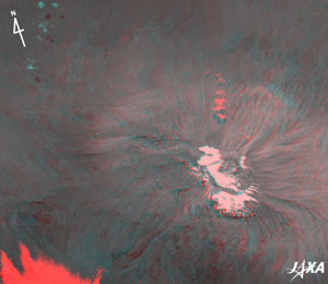 |
Fig. 3. Three-dimensional view of Kibo of Mt. Kilimanjaro acquired by AVNIR-2
(Caution should be exercised when viewing this image, as prolonged exposure could result in eye fatigue. After printing with a color printer, use this pdf file.) |
Figure 3 is a three-dimensional view of Kibo constructed using AVNIR-2 images obtained on June 14 and July 6. When viewed with red and blue colored glasses, you can see that Kibo looks upheaved like a plateau. The center of the crater is hollow, with the crest of the outer rim on the south side, and there is a steep cliff on the west side.
The red areas in the lower left and on the north side of Kibo are clouds on the July 6. The light-blue areas on the upper left are clouds on the June 14.
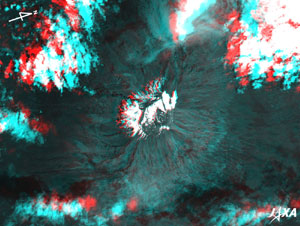 |
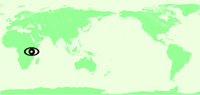
Fig. 4. Three-dimensional view of Kibo of Mt. Kilimanjaro acquired by PRISM
(Caution should be exercised when viewing this image, as prolonged exposure could result in eye fatigue. After printing with a color printer, use this pdf file.) |
Figure 4 is the June 12 three-dimensional view constructed by using PRISM's nadir-looking image and backward-looking image. In this image, north is to the right. When viewed with red and blue colored glasses as with Fig. 3, you can see that the rim of the crater is shaped like a doughnut. There is more detailed unevenness of the flank of Kibo in addition to the unevenness of Kibo that can be seen in Fig. 3.
At the beginning of the 20th century, the entire mountaintop (Kibo) of Mt. Kilimanjaro was covered with snow and ice. Since that time, the snow and ice area has been decreasing rapidly. According to a group from Ohio State University, USA, the ice fields on the mountaintop could disappear before 2020.
Explanation of the images:
Figs. 1 to 3
| Satellite: |
Advanced Land-Observing Satellite (ALOS) (Daichi) |
| Sensor: |
Advanced Visible Near-Infrared Radiometer type-2 (AVNIR-2) |
| Date: |
0819 (UT) on June 15, 2006 (Fig. 1 except for the mountaintop),0806 (UT) on June 5, 2006 (the mountaintop of Fig. 1),0739 (UT) on June 14, 2006 (center and right of Fig. 2 and blue and green of Fig. 3),0748 (UT) on July 6, 2006 (left of Fig. 2 and red of Fig. 3) |
| Pointing angle: |
41.50° (Fig. 1 except for the mountaintop)
21.50° (the mountaintop of Fig. 1 )
-34.30° (center and right of Fig. 2 and blue and green of Fig. 3)
-21.50° (left of Fig. 2 and red of Fig. 3)
|
| Ground resolution: |
10 m |
| Map Projection: |
Universal Transversal Mercator (UTM) |
AVNIR-2 observes the Earth's surface with its four spectral bands and is equipped with a pointing function by which it can shift its observation area from nadir to oblique bottom perpendicular to ALOS's moving direction.
The color composition of Fig. 1 was made by assigning visible Band 3 (610 to 690 nm) for red, near-infrared Band 4 (760 to 890 nm) for green and visible Band 1 (420 to 500 nm) for blue. As a result, the figure has a natural coloring with slightly emphasized vegetation. Clouds, snow and ice look white or light purple; forests, dark green; grasslands and farmlands, light green; sparse vegetation area, khaki; exposed rocks, soils and sands, purple; and water surfaces (lakes, ponds, and rivers), dark blue.
The color composition of Fig. 2 was made by assigning visible Band 3 (610 to 690 nm) for red, visible Band 2 (520 to 600 nm) for green and visible Band 1 (420 to 500 nm) for blue. As a result, the figure has a natural coloring as if seen by the naked eye. Clouds, snow and ice appear white; exposed rocks, soils and sands, brownish; and grasslands, greenish.
Figure 3 was produced using the Band 3 image observed with a pointing angle of -34.30° on June 14 (green and blue) and the Band 3 image observed with a pointing angle of -21.50° on July 6 (red). In Fig. 3, we utilize the difference between the pointing angles perpendicular to the satellite moving direction as the parallax, therefore the lower side is the satellite moving direction and the upper side corresponds nearly to north.
|
Fig. 4
| Satellite: |
Advanced Land-Observing Satellite (ALOS) (Daichi) |
| Sensor: |
Panchromatic Remote-Sensing Instrument for Stereo Mapping (PRISM) |
| Date: |
0756 (UT) on June 12, 2006 |
| Ground resolution: |
2.5 m |
| Map Projection: |
Universal Transversal Mercator (UTM) |
PRISM is an optical sensor for observing ground surfaces with visible and near-infrared signals in the 520 to 770 nano-meter (one-billionth of a meter) band. The acquired image is monochrome. PRISM has three independent optical systems (telescopes) to acquire terrain data including altitude data so that images for nadir, forward, and backward views can be acquired at the same time.
Figure 4 was composed using the nadir image (green and blue) and the backward image (red). Parallax, the difference between the sight angle of the image seen with the right and left eyes, is utilized in order to view the three dimensional image. In Fig. 4, the left side is the satellite moving direction because the backward image of the satellite is seen with the left eye and the nadir image with the right eye. The left side corresponds to the satellite moving direction, and the right, nearly to north.
|
|
 |
|


