Seen from Space 2004
The Gift of the Nile: Egypt
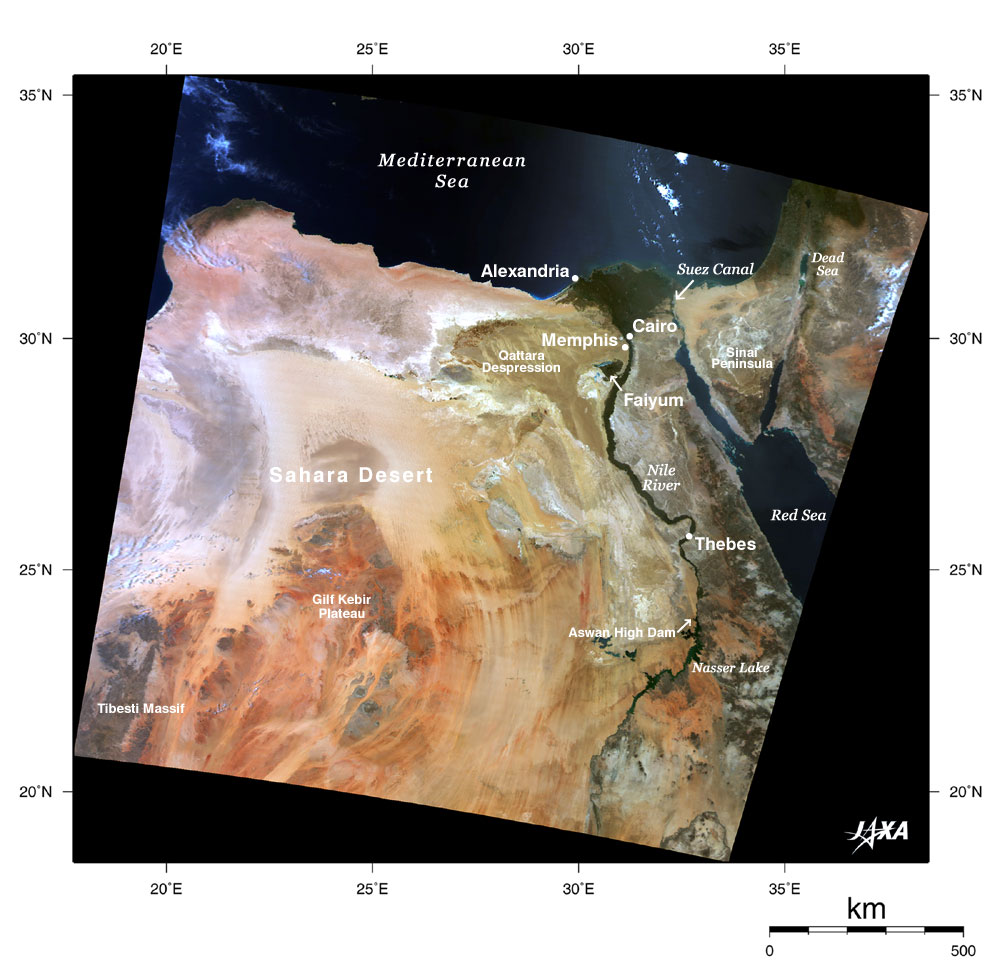
This image covers Egypt in the center, eastern Libya on the left, and Jordan and Israel in the upper right. In the greater part of the image, pale orange or brown indicates arid desert, but an impressive green line can be seen growing from south to north and finally spreading out as a fan. This corresponds to Lake Nasser dammed by Aswan high dam, green land on the both banks of the lower Nile, and the Nile delta, a fertile alluvial fan north of Cairo. The green "leaf" in the lower left of the Nile delta is the vast rich area called "El-Faiyum," which includes the tributaries pouring into Lake Qarun. Around 500 BC, Herodotus, the Greek historian, descibed Egypt as "the gift of th Nile" in his book "the History," and the description is true of this image if you replace "Egypt" with "green land in Egypt." The Nile is the world's longest river, streching to a full length of 6,650 km (about four times the distance between Sapporo and Kagoshima). Several World Heritage sites are located along the Nile, such as "Memphis and its Necropolis - the Pyramid Fields from Giza to Dahshur" and "Ancient Thebes with its Necropolis," including the tomb of Tutankhamen. Brown, reddish brown and grey parts in the Sahara are considered exposed surfaces of the ground and rocks. White indicates areas covered with sand, and the many whitish stripes running in the north-south direction represent unique desert geographical features formed by weathering. The Sahara is a desert at present, but rock art of about 12,000 to 6,000 years ago discovered in the Sahara demonstrates that it was wet at one time. There were forests and grasslands inhabited by giraffe, elephant, antelope (herbivorous animal bovidae), and rhinoceros, and hunting was practiced. The Sahara began drying up around 5,000 years ago. The drying occurred about 3,100 BC to 525 BC when ancient Egypt prospered. The Wisconsinan or Weichsel glacial period extended from about 70,000 years ago to about 12,000 years ago, and the air temperature in Antarctica at that time was about 8 C lower than at present. However, the increase in air temperature when the glacial period ended about 12,000 years ago initiated the retreat of the continental glaciers and rise in sea levels. The climate pattern, such as rainfall, thus changed significantly, resulting in the Sahara's present status. Related topics: http://sharaku.eorc.jaxa.jp/ADEOS2/library/20030320/0320.html http://sharaku.eorc.jaxa.jp/ADEOS2/library/20030404/0404.html Explanation of the image Satellite: ADEOS-II (Midori-II) Sensor: Global Imager (GLI) Date of observation: May 10, 2003 This is a composite image generated from GLI's three visible spectral channels, channel 13 (678 nm; red), channel 8 (545 nm; green), and channel 5 (460 nm; blue). This combination yields colors similar to those as seen by the human eye. The original resolution is 1 km. |