Seen from Space 2006
ALOS (Daichi) observes Earthquake Stricken Area in central Java, Indonesia
| |
 |
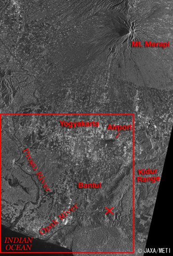
Fig.1 Image observed by PALSAR aboard ALOS after the earthquake
Yogyakarta (kmz, 1.60 MB, Low Resolution) as seen on Google Earth.
( Guide map of Java. You can see many volcaos lying in an east-west direction.) Guide map of Java. You can see many volcaos lying in an east-west direction.) |
The Phased Array type L-band Synthetic Aperture Radar (PALSAR) and the Advanced Visible and Near Infrared Radiometer type-2 (AVNIR-2) aboard the Advanced Land Observing Satellite (ALOS) "Daichi" observed districts stricken by the earthquake in the central Java, Indonesia on May 28 after the earthquake. Figure 1 is the PALSAR Image. The city areas in Yogyakarta look bright in the center of Fig. 1. Mt. Merapi is in the upper right and the Progo River and the Opak River flows and empties into the Indian Ocean in the lower left. The airport looks black because the runway does not reflect the radiowave back to the satellite. The X at the bottom indicates the epicenter of the earthquake released by USGS.
 |
 |
| Fig.2a Image observed by PALSAR on May 16 before the earthquake |
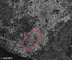
Fig.2b Image observed by PALSAR on May 28 after the earthquake |
Fig. 2b shows the distribution of reflection strength (texture) of PALSAR radar waves within the red frame of Fig.1. Comparing the distribution of texture before and after the earthquake (May 16 and 28 respectively), you can see that the reflection strength became weaker (or darker in the image) after the earthquake not only in the nearby area of the epicenter but all over the city areas. (You can see a clearer difference especially in the area encircled in red.) In general, the strength distribution of radar reflection wave is bigger in city areas and smaller in forests.
The reduction of texture means that the earthquake was big enough to destroy artificial structures such as buildings.
Please refer to the ALOS New-Arrived Images page.
JAXA provided the observed image data and analyzed image data to the following organizations.The International Charter "Space and Major Disasters"
The National Institute of Aeronautics and Space of Indonesia (LAPAN)
Our heartfelt sympathy goes out to all who suffered from this disaster, and we pray that they will soon recover from the disaster.
Explanation of the images:
(Figs. 1 and 2)
| Satellite: |
Advanced Land Observing Satellite (ALOS)(Daichi) |
| Sensor: |
Phased Array type L-band Synthetic Aperture Radar (PALSAR) |
| Date: |
1145 (JST) on May 16, 2006 (Fig.2a)
1140 (JST) on May 28, 2006 (Figs. 1 and 2b)
|
| Frequency: |
1,270 MHz (L band) |
| Ground resolution: |
10 m |
| Map projection: |
UTM |
|
The PALSAR is an upgraded Synthetic Aperture Radar (SAR) onboard the Japan Earth Resources Satellite-1 (JERS-1) with improved function and performance. It is an active type microwave sensor, which can carry our observations day and night regardless of weather conditions. The PALSAR is equipped with a function to change its observation direction and observation mode to cover wider range (Scan SAR.) The radar is developed in cooperation with the Japan Resources Observation System Organization (JAROS) of the Ministry of Economy, Trade and Industry (METI.) |
(Guide map)
| Satellite: |
Japanese Earth Resources Satellite-1 (JERS-1)(Fuyo-1) |
| Sensor: |
Synthetic Aperture Radar (SAR) |
| Date: |
1998 |
| Frequency: |
1,275 MHz (L band) |
| Ground resolution: |
18 m |
| Map projection: |
UTM |
|
The SAR is an active type microwave sensor, which can carry our observations day and night regardless of weather conditions. The SAR was developed in cooperation between the Japan Resources Observation System Organization (JAROS) of the Ministry of Economy, Trade and Industry and NASDA (present JAXA). |
|
 |
|


