Ver. 10 (Jan 24, 2024)

Japan International Cooperation Agency (JICA)

Japan Aerospace Exploration Agency (JAXA)

JJ-FAST Technical Note

1. System overview

The New JICA-JAXA Forest Early Warning System in the Tropics (JJ-FAST) employs JAXA’s next-generation deforestation detection algorithm to spot deforestation areas with size larger than 1.5 hectares (Ver. 4.0, as of April 2023). Exploiting Japan’s state-of-the-art radar Earth observation (EO) technology together with powerful next-generation algorithms, detections can be made even under the thick cloud cover which is characteristic for tropical regions especially during the rainy seasons. Most importantly, as the New JJ-FAST aims to finally function as a veritable Early Warning System, the new algorithms focus on detection only fresh and ongoing deforestation activities. Reliable deforestation polygons will be published online on the JJ-FAST website only 3 days after the ALOS-2 image acquisition giving local authorities enough time to take meaningful actions.

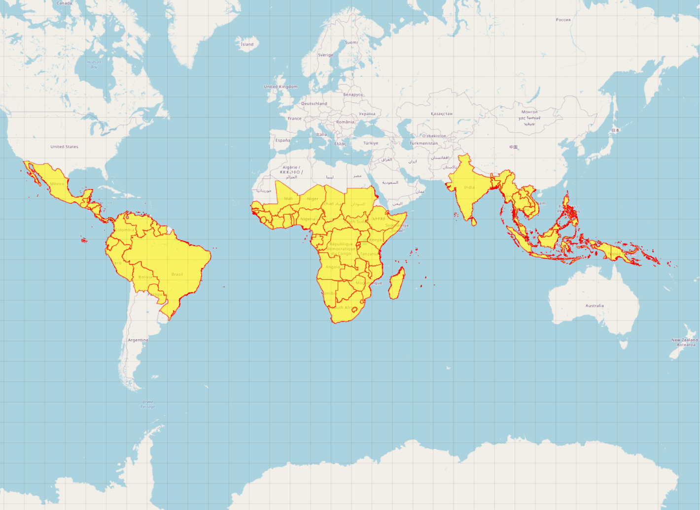
Fig.1 The 78 JJ-FAST target countries in the tropical belt

The system detects deforestation by means of L-band (1.25 MHz) Synthetic Aperture Radar (SAR) data acquired by the PALSAR-2 sensor aboard JAXA's Advanced Land Observing Satellite 2 (ALOS-2) and provides geolocated polygons for every detected site free of charge via its web service. To achieve full areal coverage of the entire tropical forest belt, ALOS-2 operated in ScanSAR mode which has a 350-km swath at the cost of reduced image resolution. The ALOS-2 JJ-FAST image data comes at a natural resolution of 50-m. Hence, the potential to track very small-scale deforestation is limited by the coarse spatial resolution. With unique Early Warning capabilities and frequent updates, approximately every 1.5 months, JJ-FAST can serve as an effective deterrent against illegal deforestation activities when forest authorities in the target countries act accordingly on the JJ-FAST alerts. Government forest authorities of tropical countries with large forest inventories are targeted as the main users of JJ-FAST. Since the Early Warning polygons of detected deforestations cannot only be conveniently viewed online, but also downloaded for further GIS analysis, local authorities are able to effectively identify illegal activities by comparing JJ-FAST detections with available national land use maps and/or concession maps. The target region of JJ-FAST includes 78 countries (Fig. 1, Tab. 1), covering almost the entire tropical forest belt.

Table 1 List of JJ-FAST target countries by regions
Region Country
South America Bolivia, Brazil, Colombia, Ecuador, Guyana, Paraguay, Peru, Suriname, Venezuela
Central America Belize, Costa Rica, El Salvador, Guatemala, Honduras, Mexico, Nicaragua, Panama, Trinidad and Tobago
Africa Benin, Burkina Faso, Cote d’Ivoire, Ghana, Guinea, Guinea-Bissau, Liberia, Mali, Nigeria, Senegal, Sierra Leone, Togo, Burundi, Djibouti, Ethiopia, Kenya, Rwanda, Seychelles, Somalia, Sudan, South Sudan, Tanzania, Uganda, Cameroon, Central African Republic, Chad, Republic of Congo, Democratic Republic of Congo, Equatorial Guinea, Gabon, Madagascar, Angola, Botswana, Lesotho, Malawi, Mauritius, Mozambique, Namibia, Republic of South Africa, Sao Tome and Principe, Swaziland, Zambia, Zimbabwe
Asia Bangladesh, Bhutan, Brunei, Cambodia, India, Indonesia, Laos, Malaysia, Myanmar, Nepal, Philippines, Sri Lanka, Thailand, Timor-Leste, Viet Nam
Oceania Papua New Guinea, Solomon Islands

2. JJ-FAST Product Description

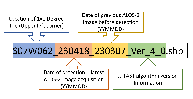
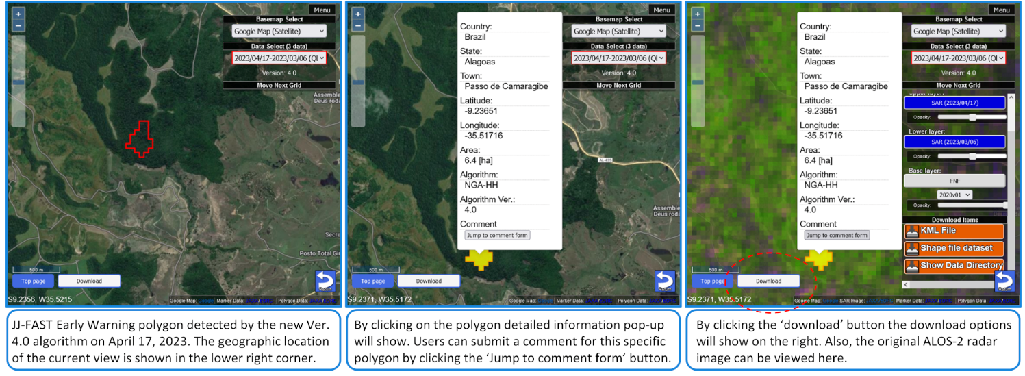
JJ-FAST does not only allow to view Early Warning polygons online on the interactive map, but all the deforestation polygons can be downloaded by users in units of 1°×1° tiles. The download file can be selected from two types of formats: ESRI Shape format or KML format. The file naming convention is explained in Figure 2. Most importantly users should note that the date of detection is provided in the filename of every JJ-FAST product in for of 6 digits (YYMMDD) date forma. The second date indicates the last observation prior the detection. The attribute information shown in Figure 3 is attached to each polygon. WGS84 is used as a geodetic system in the geographic coordinate system (latitude and longitude coordinates).
JJ-FAST early warning polygon attributes are summarized in Table 2. Note that the attribute information for Ver. 4.0 is different from this, as shown in Table 3.

Fig.2 Description of the JJ-FAST product file name convention.
Fig.3 Example of JJ-FAST Website display with attributes of the New Ver. 4.0.
Table 2 Attribute information of the deforestation polygon
Field name Pop-up name Contents
Country Country Country name where the polygon center is located
Continent - Continent name where the polygon center is located
ChangeArea Change Area Area of polygon (in hectares)
Accuracy Reliability Reliability of detection results (for Ver. 3.2): 
1 = high reliability (the change of PALSAR-2 images exceeds the threshold of Table A3 by 1.0 dB) 
2 = medium reliability (the change exceeds the threshold)
Polygon_id - ID for identifying each polygon
State State State name where the polygon center is located
Town Town Town name where the polygon center is located
Latitude Latitude Latitude of the polygon center
Longitude Longitude Longitude of the polygon center
Algorithm Algorithm Methodology of deforestation detection
AlgoVer Algorithm Ver. Version of algorithm
Threshold Threshold Threshold area defined for version-3 algorithm

Table 3 Attribute information of the deforestation polygon of the New Ver. 4.0.
Field name Pop-up name Contents
Polygon_ID Country Unique identifier for each Early Warning polygon
Latitude Lat Latitude of the polygon center in decimal degree
Longitude Lon Longitude of the polygon center in decimal degree
Area Area [ha] Size of deforested area in hectares
Algorithm Algorithm Name of the next-generation algorithm (NGA)
Algorithm Ver. Version JJ-FAST version
Country Country Country name where the polygon is located
State State State name where the polygon is located
Town Town Town name where the polygon is located


Every downloaded JJ-FAST polygon shapefile is accompanied by a system control file in the form of a JavaScript Object Notation (JSON) file (file extension “.json” ). In the JSON file, the source data and the polygon information are described with the key of “source_data” and “polygon_info” respectively. The “source_data” lists the information of time-series PALSAR-2 images processed for forest change detection and the “polygon_info” lists the polygon attributes for each polygon. The JSON data structure description can be found in Table 8A in the appendix.


3. ALOS-2 Time-Series Data Acquisition and ScanSAR Imaging Algorithms

The dual-polarization ScanSAR mode of ALOS-2 is used to observe the whole region in both HH and HV polarization with frequent revisits at least nine times per year. The ScanSAR mode covers a wide-area observation of 350 km swath by scanning five 70km-sub-swathes. For more information, see the folling web site.https://www.eorc.jaxa.jp/ALOS-2/en/about/palsar2.htm

Most of the ScanSAR data, that are acquired following the ALOS-2 Basic Observation Scenario (BOS) and fully or partially cover the target region, are extracted from level 1.0 data and are long-strip imaged using the Sigma-SAR processor to prepare for the later time series datasets. Maximum imaging length sometime reaches up to 3,000 km. Time-varying SAR parameters are properly corrected and the uniform long-strip images are produced. To suppress the speckle noise, 4 range samples are averaged and 50-meter subsampling in azimuth are adopted. Specan algorithm was adopted for quicker processing and the scalloping minimization was conducted. After this, the ortho-rectification and slope correction (as the radiometric terrain correction) using the AW3D30-DEM, EGM96 geoid model, and GRS80 georeference system are performed. Finally, the data are projected onto the Equirectangular map at 50-m pixel spacing. Detailed processing algorithms are described in the following reference (Shimada, 2018). Radiometric and geometric calibrations were conducted using the known calibration sites.

A detailed overview of the PALSAR-2 data and the various ancillary data used in the JJ-FAST processing scheme is provided in Table A6 and Table A7, respectively, in the Appendix of this document.

4. Deforestation detection algorithm

The NEW JJ-FAST Ver. 4.0 employs the Next-Generation Algorithm (NGA) which finally achieves veritable Early Warning capability and unrivaled reliability. The extremely powerful and future proof NGA is a completely new development breaking with all prior, insufficient algorithm generations. It is expected that no major algorithm changes will be required in the future.

Prior to the launch of the New JJ-FAST, five different algorithm versions for deforestation detection have been used (Table 4). The most current algorithm was Ver 3.2 as introduced in September 2022. This algorithm will be described in this section flowing the introduction of the next-generation algorithm that replace all previous generations. Detailed description of the older discontinued algorithm versions 0.0 - 3.1 can be found in the appendix of this document. It should be pointed that due to the insufficiency of previous JJ-FAST versions we do not recommend relying on detections made before September 2022 as the results were generally not very reliable.

Table 4 Revision history of the deforestation detection algorithm
Algorithm version Application period Algorithm
Ver. 0.0 2016.11 - 2017.07 Change detection between 2 images of PALSAR-2 HV
Ver. 1.0 2017.07 - 2018.04 Change detection between 2 images of PALSAR-2 HV
Ver. 2.0 2018.04 - 2018.07 Analysis using a reference from 10 scenes of PALSAR-2 HV, HH
Ver. 2.0 2018.07 - 2019.06 Analysis using a reference from 15 scenes of PALSAR-2 HV, HH
Ver. 2.1 2019.07 - 2020.05 Analysis using a reference from 20 scenes of PALSAR-2 HV, HH with updated thresholds
Ver. 3.0 2020.06 - 2022.03 Data process unit changes from polygon to pixel base. Applying temporal normalization Introducing different threshold level depending on the site.
Ver. 3.1 1) 2022.03 - 2022.09 Applying advanced false-alarm suppression based on new pixel-based full time-series analysis.
Introduction of new PALSAR-2 ScanSAR time-series forest/non-forest mask
Ver. 3.2 2022.09 - 2023.04 The advanced false-alarm suppression and the new PALSAR-2 ScanSAR TS-FNF mask, introduced in Latin America in Ver. 3.1, are now used in the entire JJ-FAST area.
The 'Sigma-SAR' ScanSAR processor was upgraded from v2.4.0 to v3.0.0.
Ver. 4.0 2023.04 –2023.11 The NEW JJ-FAST employs the Next-Generation Algorithm (NGA) which finally achieves veritable Early Warning capability and unrivaled reliability. The powerful and future proof NGA is a completely new development breaking with all prior algorithm generations.
Ver. 4.1 2023.11 – The parametrization of the new Ealy Warning algorithm was improved based on field survey data and the comprehensive validation data from the three validation supersites in Brazil. A new HV change detection algorithm was introduced to enable detections of deforestation cases which are not suitable for Early Warning detection.

1)Ver. 3.1 was used in only Latin America while Ver. 3.0 was used in Africa, Asia, and Oceania.


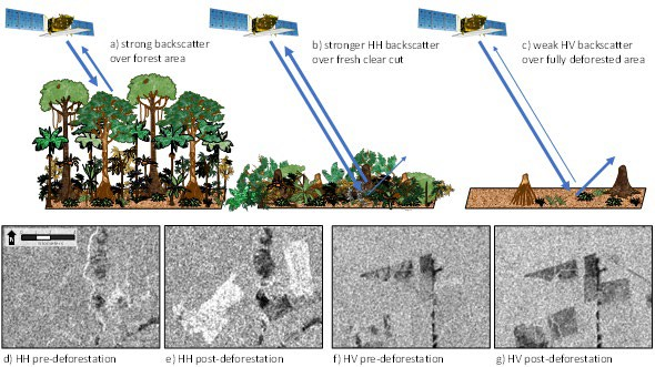
Fig. 4 Schematic of the deforestation detection principle by increasing HH backscatter (a, b, d, e) or decreasing HV backscatter (a, c, f, g).

■ Next-generation algorithm (JJ-FAST Ver. 4.0, Ver. 4.1)

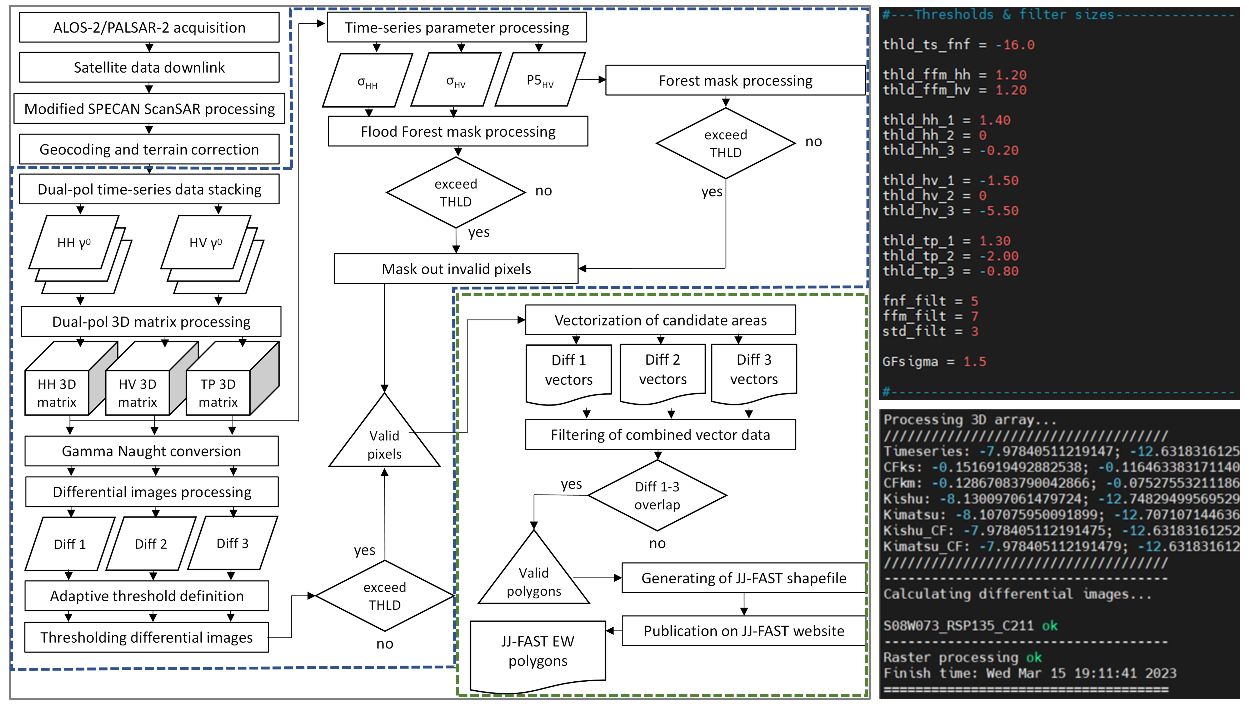
JAXA’s next-generation algorithm (NGA) used in JJ-FAST 4.0 is a powerful fully integrated dual-polarization deforestation Early Warning algorithm. Thanks to tremendous improvements, the New JJ-FAST finally realizes the first veritable deforestation Early Warning System in the tropics. Unlike the previous change detection algorithm generations, the NGA gives priority to HH change detection in order to detect only fresh and ongoing deforestations. The unreliable and ambiguous detections with long delays, as was characteristic with the Old JJ-FAST, are a thing of the past. The process flow chart of the next-generation algorithm is shown in Figure 5. The most important new features are highlighted below.


□ The New Algorithm exploits the full dual-polarization time-series information
  ・ Prioritizing HH for change detection, HV for non-forest masking
□ Forest Mask (TS-FNF) and FloodMask (TS-Mask) are processed on the fly
  ・ Forest cover information is always up to date, eliminating non-forest errors
  ・ No auxiliary data apart DEM for SAR processing and masking of steep slopes are required
  ・ Eliminates uncertainties introduced by unreliable, outdated, unsuitable external information
□ Fast processing speed
  ・ Reduces computational costs
□ Set of 9 adjustable backscatter parameters plus 3 TS parameters
  ・ Allows adaptions for wide variety of seasonal conditions, forest types, etc.
□ Advanced forest backscatter statistics calculation
  ・ Allows automatic calibration for seasonal effects and local parameter adjustments.


Fig.5 Processing flow of the next-generation deforestation detection algorithm used in Ver. 4.0.

Thanks to highly sophisticated 3D time-series processing, the next-generation algorithm can now detect the size of a deforested area with great precision.
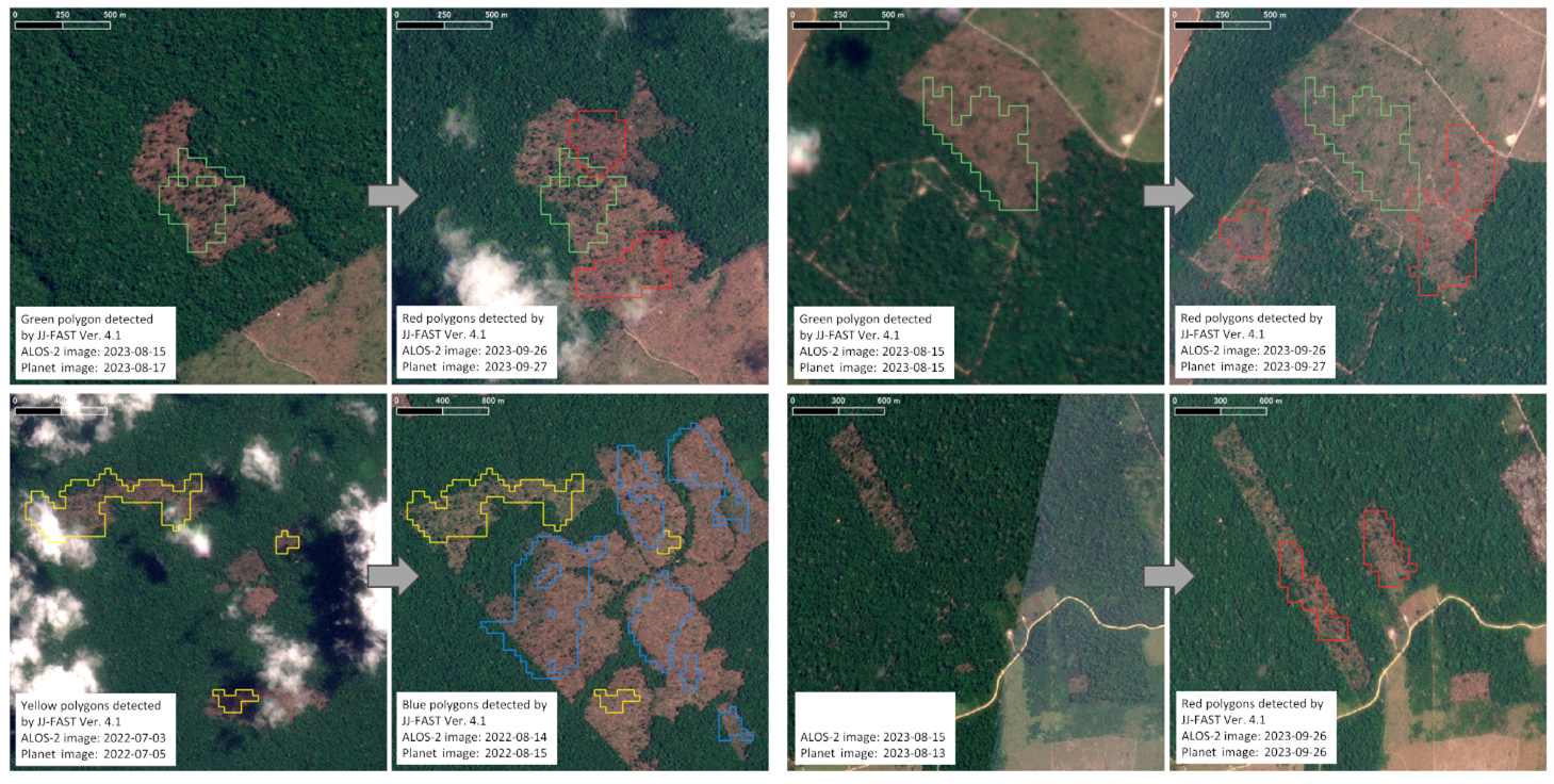
Note that the scientific research paper on the next-generation is currently being prepared for publication. The full details of this cutting-edge development will be disclosed in this Technical Note document after publication, and the research paper will be made available download as well. An example of the outstanding performance of the New JJ-FAST is shown Figure 6. The comparison with cloud-free optical Planet daily images, taken quasi-simultaneously with the ALOS-2 images, demonstrate the unmatched quality of the next-generation algorithm.

From C235, Ver. 4.0.2 introduced a new slope mask derived from the ALOS World 3D (AW3D30) DEM to reduce false alarms in mountainous area with steep topography. The maximum slope angle in Ver. 4.0 is set to 15 degrees. In addition, the Global Human Settlement Layer is used to mask out built-up areas where sometimes error detections occurred (see Table A7).

Fig.6 Examples of Early Warning polygons detected by the New JJ-FAST at 2 sites in Amazonia, Brazil. The next generation algorithm detected fresh/ongoing deforestation activity at unprecedented precision. (Image © Planet Labs PBC)
■ Algorithm Ver. 4.1

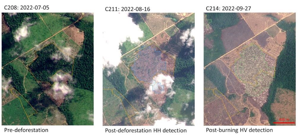
Ver 4.1 was launched for C243 on October 31, 2023. The main modifications as compared to Ver. 4.0 comprise improvement of the flood false alarm suppression as well as improved parameterization of the area dependent change detection thresholds. These improvements are largely based on findings made during a joint field survey with IBAMA in the Rio Branco region, Brazil, as well as on the validation and calibration data available for three super sites in the Legal Amazon (see Section 5). After some consideration, Ver. 4.1 reintroduced an HV algorithm, as it was found that it can improve producer’s accuracy in some cases. The new HV algorithm follows the well-known change detection principle that relates deforestation to a decrease in HV backscatter (Fig. 4). The advantage of the HV algorithm is that it can detect very small forest cover changes with a minimum size of only 1 ha. However, it is important to note that in general Ver. 4.1 gives priority to the next-generation HH early warning algorithm. In most cases the HV algorithm in fact redetects deforestation areas that have previously already been detected by the HH early warning main algorithm as shown in Fig. 7.


Fig. 7 Example of an Early Warning polygon detected by the Ver 4.1 HH algorithm and the redetection by the HV algorithm during the next observation cycle. (Image © Planet Labs PBC)

5. Verification

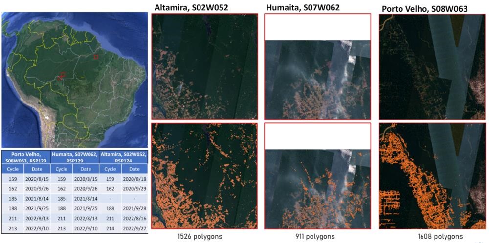
To assess the early warning accuracy of the new Ver. 4.1 algorithm in the most reliable fashion possible, we employed a very strict validation procedure. At three test sites in the Brazilian legal Amazon, Planet daily imagery was used to map the forest loss conditions for 6 ALOS-2 observation cycles between 2020 and 2022. All deforestations occurring between 2 consecutive PALSAR observations during these periods were carefully mapped to allow a coherent validation of both user’s and producer’s accuracies. The number of cycles is limited, because these were the only terms where almost completely cloud free conditions allowed to create such a validation dataset from optical satellite data. Each of the test sites covers an area of 1° by 1° or approximately 110 km by 110 km. The test sites are located in the area of Porto Velho (s08W063) and Humaitá (S07W062) in the State of Rondonia as well as in Altamira (S02W052) in the state of Para (Fig. 8). Of course, the visual interpretation of optical images can realistically not be 100% correct. Especially phenological changes in the canopy are often very difficult to distinguish from actual deforestation. Therefore, a certain degree of uncertainty must be taken into account. However, we believe that the datasets are indeed reliable enough to obtain meaningful accuracy numbers. Moreover, most errors contained in the validation data sets will result in lower accuracy numbers for the ALOS-2 early warning performance. Hence the true accuracy of the new Ver. 4.1 should be rather underestimated than overestimated. An overview ‘ground truth’ data available for validation is shown in Table 2.

Fig. 8 Three validation and calibration super sites in the Brazilain Legal Amazon.
Table 5 Overview of Planet based ‘ground truth’ data for three large-scale validation sites in Brazil.
Test site  Altamira Humaitá Porto Velho
Location  S02W052 S07W062 S08W063
Area (km2)   001-2298 001-2206 001-2177
RSP path  123, 124 128, 129 129, 130
Cycle Season Ground truth polygon count
159 004-4044 119 108 315
162 004-4075 304 213 260
185 004-4409 176 165 308
188 004-4440 329 173 364
208 004-4774 230 138 203
211 004-4805 368 114 158
Sum  015-26 911 016-08

From the available validation efforts, using some 4045 deforestation cases distributed over the three 1° by 1° validation sites and 6 different dates, it was confirmed that the producer’s accuracy range between 38.2% and 62.4% depending mainly on seasonal and rainfall conditions. The user’s accuracy ranged between 49.3% and 75.7%. The average producer’s accuracy and user’s accuracy taking into account all validation data combined is 44.5% and 64.2%, respectively. It is important to note that in this study we consider a true detection exclusively as the case where the forest cover loss occurred before the last observation and after the previous observation, i.e., between the 2 latest image acquisitions. Given the nominal repeat interval of 42 -days (every third repeat cycle) plus the 3-days required for processing the PALSAR-2 data to obtain the final deforestation polygons and publish them online, this implies that a fresh and ongoing logging activities can be not older than 45-days in the worst case. In many hot spot areas in the amazon basin the repeat intervals are only 28 days (every second repeat cycle), and in some rarer cases even up to 14 days (1 repeat cycle). Moreover, for the trained eye it is easy to tell which of the polygons are “live” and have priority to be inspected by authorities. The average time lag between start of deforestation activities and successful detection by ALOS-2 was 15 days. This should be well enough time to act on most of the early warning produced by the Ver. 4.1 algorithm.

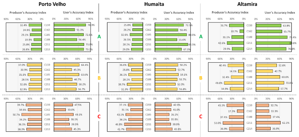
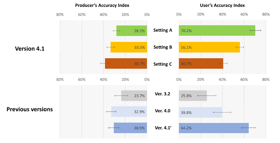
To test the potential to adjust the Ver. 4.1 algorithm to specific users’ requirements three different parameter models were developed with A) optimized for highest user’s accuracy, C) optimized for highest producer’s accuracy, and B) and intermediate model optimized for a balance between user’s and producer’s accuracy. The detailed validation results for each cycle and each test site are shown in Fig. 9. The summary and final overall accuracy numbers for the 3 parameter A, B, and C are shown in Fig. 10. The comparison with Ver. 4.0 and Ver. 3.2 demonstrates the improved performance of the latest JJ-FAST algorithm.

Note that based on the user requirements in the Amazon area, parameter setting A is used in South America, whereas parameter setting B is adopted in all other JJ-FAST regions, i.e. Central America, Africa, and South and Southeast Asia.

Fig. 9 Detailed validation results for the three parameter settings A, B, and C for each test site and each observation cycle.

Fig. 10 Overall accuracy of the three parameter settings A, B, and C of Ver 4.1 and comparison with previous algorithm generations Ver. 4.0 and Ver. 3.2.

Figure 11 shows some validation examples of JJ-FAST early warning polygons. The examples taken from a recent observation in the Altamira test site during ALOS-2 observation cycle 240 on 26 September 2023 demonstrate the unique capability of the PALSAR-2 data and the next-generation early warning algorithm to detect fresh and ongoing deforestation in the humid tropical forest areas.

Fig. 11 Examples of early warning polygons detected by the fully automatic JJ-FAST Ver. 4.1 algorithm in the Altamira Cal/Val site, State of Para, Brazil. (Images © Planet Labs)

6. Two types of Old JJ-FAST products, QL and QC (discontinued)

From 1 July, 2019, to 17 April 2023, JJ-FAST has been delivering two types of polygon products for JJ-FAST Ver 2.x and Ver. 3.x, namely Quick Look (QL) and Quality Checked (QC). QL products were available shortly after the ALOS-2 observations with a delay of only 3-4 days. Polygons distributed via the QL products contain all deforestations detected by the Old JJ-FAST algorithm. Note that the QL deforestation polygons are validated and therefore show significantly higher false alarm rates and low accuracy. The usual “Quality Checked” (QC) products with validated deforestation polygons will be released 4-7 days after the observations as always. The locations of the latest QL and QC detections are shown as purple and red pins on the JJ-FAST map, respectively. As before, the locations of all past deforestation detections will be shown as yellow pins.
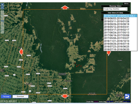
For archived JJ-FAST data from the given period, users can select the QC or QL polygons by using the Data Select menu in which QL polygons can be identified by text “(QL)” in the list (Fig.12) and QC polygons are listed in observation term only (without (QL)).
The filename of QL products has a string “_QL” before extension (e.g. S10W062_190701_190422_02_QL.shp).

Fig.12 Example of the Data Select

7. Bibliography

■ Academic journals

Shimada, M. et al. (2014): New global forest/non-forest maps from ALOS PALSAR data (2007-2010), Remote Sensing of Environment, 155, 13-31. https://doi.org/10.1016/j.rse.2014.04.014

Motohka, T. & Hayashi, M. (2017): Forest observation from space by the satellite Daichi-2. Seibutsu-no-kagaku Iden, 71(1), 70-76. [in Japanese]

Watanabe, M. et al. (2018): Early-stage deforestation detection in the tropics with L-band SAR, IEEE Journal of Selected Topics in Applied Earth Observations and Remote Sensing, 11(6), 1-7. https://doi.org/10.1109/ JSTARS.2018.2810857

Koyama, C. et al. (2019): Mapping the spatial-temporal variability of tropical forests by ALOS-2 L-band SAR big data analysis, 233, 111372.

Watanabe, M. et al. (2021): Refined algorithm for forest early warning system with ALOS-2/PALSAR-2 ScanSAR data in tropical forest regions, Remote Sensing of Environment, 265, 112643.

■ Book

Shimada, M. (2018): Imaging from spaceborne and airborne SARs, Calibration, and Applications, CRC press.

■Conference proceedings

Watanabe, M. et al. (2016): Examination of a method of early deforestation detection (advanced) using PALSAR-2/ScanSAR for JICA-JAXA Forest Early Warning System in the Tropics (JJ-FAST). Journal of the Remote Sensing Society of Japan, 61, p. 21.

Ogawa, T. et al. (2016): Examination of a method of extracting changes and the results of a prototype production in JICA-JAXA Forest Early Warning System in the Tropics (JJ-FAST). Journal of the Remote Sensing Society of Japan, 61, p. 257.

Koyama, C.N. et al. (2016): Fundamental study on soil moisture variations under vegetation influencing L-band SAR backscatter - implementations for the development of an advanced forest monitoring system. Proc. of 61th Autumn Conference of the Remote Sensing Society of Japan, Nov. 1-2, Niigata, Japan, pp. 145-146.

Hayashi, M. et al. (2017): Deforestation detection using ALOS-2/PALSAR-2 for JICA-JAXA Forest Early Warning System in the Tropics (JJ-FAST). Journal of the Japanese Forest Society, 128 https://www.jstage.jst.go.jp/article/jfsc/128/0/128_44/_article/-char/ja/ (Access in September, 2017)

Hayashi, M. et al. (2017): ALOS-2/PALSAR-2 utilization for deforestation detection in JICA-JAXA Forest Early Warning System in the Tropics (JJ-FAST). International Symposium on Remote Sensing 2017.

Watanabe, M. et al. (2017): Early-stage deforestation areas observed with L-band (PALSAR-2) and C-band (Sentinel-1) SAR. International Symposium on Remote Sensing 2017.

Watanabe, M. et al. (2017): Examination the 3rd of early deforestation detection method (advanced) using PALSAR-2/ScanSAR for JICA-JAXA Forest Early Warning System in the Tropics (JJ-FAST). Results of time-sequential analysis in South America -. JpGU-AGU Joint Meeting 2017. https://confit.atlas.jp/guide/event/jpguagu2017/subject/STT57-06/date?cryptoId= (Access in September, 2017)

Hayashi, M. et al. (2017): Deforestation detection using ALOS-2/PALSAR-2 imagery in JICA-JAXA Forest Early Warning System in the Tropics (JJ-FAST). 31st International Symposium on Space Technology and Science (ISTS).

Watanabe, M. et al. (2017): Development of early-stage deforestation detection algorithm (advanced) with palsar-2/scansar for jica-jaxa program (jj-fast). IEEE International Geoscience and Remote Sensing Symposium (IGARSS) 2017.

Watanabe, M. et al. (2017): Polarimetric characteristics of L-band SAR images of early-stage deforestation areas. IEEE International Geoscience and Remote Sensing Symposium (IGARSS) 2017.

Koyama, C.N. et al. (2017): The Effect of Precipitation and Soil Moisture Variations on (Partial) Polarimetric L-band SAR Backscatter in Tropical Forest regions. Proc. of IEEE International Geoscience and Remote Sensing Symposium (IGARSS), July 23-28, Fort Worth, USA, pp. 2719-2722.

Koyama, C.N. et al. (2018): Tropical forest classification based on multi-temporal ALOS-2/PALSAR-2 ScanSAR observations. Proc. of 65th Autumn Conference of the Remote Sensing Society of Japan, pp. 51-52.

Watanabe, M. et al. (2019): Improvement of Deforestation Detection Algorithms used in JJ-FAST, IEEE International Geoscience and Remote Sensing Symposium (IGARSS) 2019

Koyama, C.N. et al. (2019): Mapping Spatial-Temporal Forest Heterogeneity in the Tropical Belt by ALOS-2/PALSAR-2 Big Data Analysis, IEEE International Geoscience and Remote Sensing Symposium (IGARSS) 2019

Nagatani, I. et al. (2019): Pixel-Based Deforestation Detection Algorithm for ALOS-2/PALSAR-2, IEEE International Geoscience and Remote Sensing Symposium (IGARSS) 2019, July 28 - August 2, Yokohama, Japan, pp. 5332-5335.

Nagatani, I. et al. (2020): Seasonal Change Analysis for ALOS-2 PALSAR-2 Deforestation Detection, IEEE International Geoscience and Remote Sensing Symposium (IGARSS) 2020, September 26 - October 2, Virtual Event, pp. 3807-3810.

Watanabe, M. et al. (2020): Trial of Deforestation Detection by Using 25m Resolution PALSAR-2/ScanSAR Data, IEEE International Geoscience and Remote Sensing Symposium (IGARSS) 2020, September 26 - October 2, Virtual Event, pp. 3784-3787.

Koyama, C.N. et al. (2020): Rainfall-Induced Changes in L-Band Backscatter Over Tropical Forests and Their Impact on Deforestation Monitoring, IEEE International Geoscience and Remote Sensing Symposium (IGARSS) 2020, September 26 - October 2, Virtual Event, pp. 3799-3802.

Koyama, C.N. et al. (2021): Improving L-Band SAR Forest Monitoring by Big Data Deep Learning Based on ALOS-2 5 Years Pan-Tropical Observations, IEEE International Geoscience and Remote Sensing Symposium (IGARSS) 2019, July 12 - 16, Virtual Event, pp. 6747-6500.

Watanabe, M. et al. (2021): Trial of Detection Accuracy Improvement for JJ-FAST Deforestation Detection Algorithm Using Deep Learning, IEEE International Geoscience and Remote Sensing Symposium (IGARSS) 2019, July 12 - 16, Virtual Event, pp. 2911-2914.

Koyama, C.N. et al. (2021): Assessing the Impact of Precipitation on L-band SAR Forest Observation: An ALOS-2 Big Data Case Study in the Tropics, 13th European Conference on Synthetic Aperture Radar (EUSAR 2021), March 28 - April 1, Virtual Event, 2021, pp. 1-6.

Koyama, C.N. et al. (2021): Long-Term Pantropical Forest Monitoring with ALOS-2 L-Band SAR, 7th Asia-Pacific Conference on Synthetic Aperture Radar (APSAR 2021), November 1 - 3, Virtual Event, pp. 1-5.

Koyama, C.N. et al. (2022): ALOS-2 - The Pioneer Mission for L-band SAR Long-term Pantropical Forest Monitoring, 33rd International Symposium on Space Technology (ISTS 2022), February 28 - March 4, Virtual Event, pp. 1-6.

Koyama, C.N. et al. (2022): Advancements in global forest monitoring research founded on ALOS-2 long-term pantropical land observation, IGARSS 2022, Online, July 17-22, pp. 4445-4448.

Koyama, C.N. et al. (2022): ALOS-2/PALSAR-2 Long-term Pantropical Observation - A Paradigm Shift in Global Forest Monitoring, EUSAR 2022, Leipzig, Germany, July 25-27, pp. 116-120.

Koyama, C.N. et al. (2022): Extending JAXA's long-term L-band SAR forest observation legacy with ALOS-4/PALSAR-3, SPIE Sensors & Imaging, Berlin, Germany, Sept 5-8, 1226408.

Koyama, C.N. et al. (2022): Next-generation L-band SAR deforestation algorithm for highly-accurate operational early warning in tropical forests, Proc. of 73rd Autumn Conference of the Remote Sensing Society of Japan, Nov 29-30, pp. 1-4.

Koyama, C.N., et al. (2023): ALOS-2’s Contributions to Sustainable Development Goals – Making Operational Early Warning and Near Real-Time Forest Loss Assessment a Reality Today, 34th International Symposium on Space Technology (ISTS 2023), June 3-9, Kurume, Japan, pp. 1-5.

Koyama, C.N., et al. (2023): Next-generation L-band SAR deforestation detection for operational forest early warning in the tropics, IGARSS 2023, July 16-21, Pasadena, USA, pp. 2633–2636.

Koyama, C.N., et al. (2023): Achievements of the ALOS-2 L-band SAR long-term pantropical forest monitoring mission, IGARSS 2023, July 16-21, Pasadena, USA, pp. 1994–1997.

Koyama, C.N., et al. (2023): From ALOS-2 to ALOS-4: Japan's pioneering L-band SARs for global vegetation monitoring - state-of-the-art and future perspectives, SPIE Sensors & Imaging 2023, Sep 3-6, Amsterdam, The Netherlands, 1226408.

8. Staff

■ JICA Global Environment Department Mr. Genya Nakamura
Mr. Masaru Kurimoto
Mr. Hideo Noda
■ JAXA Earth Observation Research Center Dr. Takeo Tadono
Dr. Masato Hayashi
Dr. Christian Koyama
Ms. Erina Sakaguchi
Ms. Yukari Yamazaki
Ms. Yumiko Fujita
■ Remote Sensing Technology Center Mr. Tomohiko Higashiuwatoko
Dr. Osamu Isoguchi
Mr. Kazufumi Kobayashi
Mr. Takafusa Andoh


Former Staff
■ JICA Global Environment Department Mr. Kenichi Shishido
Mr. Takahiro Morita
Ms. Kanako Adachi
Mr. Ichiro Mimura
Ms. Yoko Makita
Ms. Mari Miura
Dr. Hiroaki Okonogi
Mr. Takashi Nishimura
Mr. Takahiro Ikenoue
■ JAXA Earth Observation Research Center Mr. Yutaka Kaneko
Dr. Izumi Nagatani
Mr. Tomohiro Watanabe
■ Tokyo Denki University Prof. Masanobu Shimada
Dr. Manabu Watanabe
■ Remote Sensing Technology Center Dr. Tsutomu Yamanokuchi
Mr. Takashi Ogawa


9. Contact point

Please contact us from the question form of the following URL.

Contact Us

10. Appendix

Table A6 ALOS-2/PALSAR-2 ScanSAR data and algorithm version history
Observation cycle Observation period Applied Algorithm
45 2016.03.28 - 2016.04.10 Ver. 0.0
48 2016.05.09 - 2016.05.22 Ver. 0.0
51 2016.06.20 - 2016.07.03 Ver. 0.0
53 2016.07.18 - 2016.07.31 Ver. 0.0
56 2016.08.29 - 2016.09.11 Ver. 0.0
59 2016.10.10 - 2016.10.23 Ver. 0.0
62 2016.11.21 - 2016.12.04 Ver. 0.0
65 2017.01.02 - 2016.01.15 Ver. 0.0
68 2017.02.13 - 2016.02.26 Ver. 0.0
71 2017.03.27 - 2016.04.09 Ver. 0.0
74 2017.05.08 - 2017.05.21 Ver. 0.0
77 2017.06.19 - 2017.07.02 Ver. 0.0
79 2017.07.17 - 2017.07.30 Ver. 1.0
82 2017.08.28 - 2017.09.10 Ver. 1.0
85 2017.10.09 - 2017.07.30 Ver. 1.0
88 2017.11.20 - 2017.12.03 Ver. 1.0
91 2018.01.01 - 2018.01.14 Ver. 1.0
93 2018.01.29 - 2018.02.11 Ver. 1.0
94 2018.02.12 - 2018.02.25 Ver. 1.0
96 2018.03.12 - 2018.03.25 Ver. 1.0
97 2018.03.26 - 2018.04.08 Ver. 1.0
99 2018.04.23 - 2018.05.06 Ver. 2.0
100 2018.05.07 - 2018.05.20 Ver. 2.0
102 2018.06.04 - 2018.06.17 Ver. 2.0
103 2018.06.18 - 2018.07.01 Ver. 2.0
104 2018.07.02 - 2018.07.15 Ver. 2.0
105 2018.04.23 - 2018.05.06 Ver. 2.0
107 2018.08.13 - 2018.08.26 Ver. 2.0
108 2018.08.27 - 2018.09.09 Ver. 2.0
110 2018.09.24 - 2018.10.07 Ver. 2.0
111 2018.10.08 - 2018.10.21 Ver. 2.0
113 2018.11.05 - 2018.11.18 Ver. 2.0
114 2018.11.19 - 2018.12.02 Ver. 2.0
116 2018.12.17 - 2018.12.30 Ver. 2.0
117 2018.12.31 - 2019.01.13 Ver. 2.0
119 2019.01.28 - 2019.02.10 Ver. 2.0
120 2019.02.11 - 2019.02.24 Ver. 2.0
122 2019.03.11 - 2019.03.24 Ver. 2.0
123 2019.03.25 - 2019.04.07 Ver. 2.0
125 2019.04.22 - 2019.05.05 Ver. 2.0
126 2019.05.06 - 2019.05.19 Ver. 2.0
128 2019.06.03 - 2019.06.16 Ver. 2.0
129 2019.06.17 - 2019.06.30 Ver. 2.0
130 2019.07.01 - 2019.07.14 Ver. 2.1
131 2019.07.15 - 2019.07.28 Ver. 2.1
133 2019.08.12 - 2019.08.25 Ver. 2.1
134 2019.08.26 - 2019.09.08 Ver. 2.1
136 2019.09.23 - 2019.10.06 Ver. 2.1
137 2019.10.07 - 2019.10.20 Ver. 2.1
139 2019.11.04 - 2019.11.17 Ver. 2.1
140 2019.11.18 - 2019.12.01 Ver. 2.1
142 2019.12.06 - 2019.12.29 Ver. 2.1
143 2019.12.30 - 2020.01.12 Ver. 2.1
145 2020.01.27 - 2020.02.09 Ver. 2.1
146 2020.02.10 - 2020.02.23 Ver. 2.1
148 2020.03.09 - 2020.03.22 Ver. 2.1
149 2020.03.23 - 2020.04.05 Ver. 2.1
151 2020.04.20 - 2020.05.03 Ver. 2.1
152 2020.05.04 - 2020.05.17 Ver. 2.1
154 2020.06.01 - 2020.06.14 Ver. 3.0
155 2020.06.15 - 2020.06.28 Ver. 3.0
156 2020.06.29 - 2020.07.12 Ver. 3.0
157 2020.07.13 - 2020.07.26 Ver. 3.0
158 2020.07.27 - 2020.08.09 Ver. 3.0
159 2020.08.10 - 2020.08.23 Ver. 3.0
160 2020.08.24 - 2020.09.06 Ver. 3.0
162 2020.09.21 - 2020.10.04 Ver. 3.0
163 2020.10.05 - 2020.10.18 Ver. 3.0
165 2020.11.02 - 2020.11.15 Ver. 3.0
166 2020.11.16 - 2020.11.29 Ver. 3.0
168 2020.12.14 - 2020.12.27 Ver. 3.0
169 2020.12.28 - 2021.01.10 Ver. 3.0
171 2021.01.25 - 2021.02.07 Ver. 3.0
172 2021.02.08 - 2021.02.21 Ver. 3.0
174 2021.03.08 - 2021.03.21 Ver. 3.0
175 2021.03.22 - 2021.04.04 Ver. 3.0
177 2021.04.19 - 2021.05.02 Ver. 3.0
178 2021.05.03 - 2021.05.16 Ver. 3.0
180 2021.05.31 - 2021.06.13 Ver. 3.0
181 2021.06.14 - 2021.06.27 Ver. 3.0
182 2021.06.28 - 2021.07.11 Ver. 3.0
183 2021.07.12 - 2021.07.25 Ver. 3.0
185 2021.08.09 - 2021.08.22 Ver. 3.0
186 2021.08.23 - 2021.09.05 Ver. 3.0
188 2021.09.20 - 2021.10.03 Ver. 3.0
189 2021.10.04 - 2021.10.17 Ver. 3.0
191 2021.11.01 - 2021.11.14 Ver. 3.0
192 2021.11.15 - 2021.11.28 Ver. 3.0
194 2021.12.13 - 2021.12.26 Ver. 3.0
195 2021.12.27 - 2022.01.09 Ver. 3.0
197 2022.01.24 - 2022.02.06 Ver. 3.0
198 2022.02.07 - 2022.02.20 Ver. 3.0
200 2022.03.07 - 2022.03.20 Ver. 3.1, Ver 3.01)
201 2022.03.21 - 2022.04.03 Ver. 3.1, Ver 3.01)
203 2022.04.18 - 2022.05.01 Ver. 3.1, Ver 3.01)
204 2022.05.02 - 2022.05.15 Ver. 3.1, Ver 3.01)
206 2022.05.30 - 2022.06.12 Ver. 3.1, Ver 3.01)
207 2022.06.13 - 2022.06.26 Ver. 3.1, Ver 3.01)
208 2022.06.27 - 2022.07.10 Ver. 3.1, Ver 3.01)
209 2022.07.11 - 2022.07.24 Ver. 3.1, Ver 3.01)
211 2022.08.08 - 2022.08.21 Ver. 3.1, Ver 3.01)
212 2022.08.22 - 2022.09.04 Ver. 3.1, Ver 3.01)
214 2022.09.19 - 2022.10.02 Ver. 3.2
215 2022.10.03 - 2022.10.16 Ver. 3.2
217 2022.10.31 - 2022.11.13 Ver. 3.2
218 2022.11.14 - 2022.11.27 Ver. 3.2
220 2022.12.12 - 2022.12.25 Ver. 3.2
221 2022.12.26 - 2023.01.08 Ver. 3.2
223 2023.01.23 - 2023.02.05 Ver. 3.2
224 2023.02.06 - 2023.02.19 Ver. 3.2
226 2023.03.06 - 2023.03.19 Ver. 3.2
227 2023.03.20 - 2023.04.02 Ver. 3.2
229 2023.04.17 - 2023.04.30 Ver. 4.0
230 2023.05.01 - 2023.05.14 Ver. 4.0
232 2023.05.29 - 2023.06.11 Ver. 4.0
233 2023.06.12 - 2023.06.25 Ver. 4.0
234 2023.06.26 - 2023.07.09 Ver. 4.0
235 2023.07.10 - 2023.07.23 Ver. 4.0
237 2023.08.07 - 2023.08.20 Ver. 4.0
238 2023.08.21 - 2023.09.03 Ver. 4.0
240 2023.09.18 - 2023.10.01 Ver. 4.0
241 2023.10.02 - 2023.10.15 Ver. 4.0
243 2023.10.30 - 2023.11.12 Ver. 4.1
244 2023.11.13 - 2023.11.26 Ver. 4.1

1)Ver. 3.1 was used in Latin America and Ver. 3.0 is used in Africa, Asia, and Oceania.


Table A7 Ancillary data
Data type Data source ALOS-2 cycles Geographic region
Forest map ALOS/PALSAR forest/non-forest (FNF) map 2010 edition 45 - 82 Global
ALOS-2/PALSAR-2 FNF map 2016 edition 85 - 99 Global
ALOS-2/PALSAR-2 FNF map 2017 edition 100 - Global
ALOS-2/PALSAR-2 ScanSAR time-series FNF map 2021 edition 200 - Latin America
ALOS-2/PALSAR-2 flood forest map 2021 edition 200 - Latin America
GeoBosques forest and non-forest maps 2014 edition 85 - 99 Peru
GeoBosques forest and non-forest maps 2016 edition 100 - Peru
DFRR/JICA Botswana Forest Distribution Map 85 - Botswana
PRODES forest and non-forest maps 2017 edition 91 - Brazil
Topography Shuttle Radar Topography Mission (SRTM) - 3 45 - 229 Global
ALOS World 3D (AW3D30) DEM 235 - Global
Urban area map Global Human Settlement Layer (GHSL) 2014 edition 111 - Global
Administrative borders Database of Global Administrative Areas (GADM) ver. 2.8 45 - 99 Global
Database of Global Administrative Areas (GADM) ver. 3.6 100 - Global
Forest biomass map LUCID Land use, carbon & emission data 2019 edition 126 - Global


Table A8 JSON data structure of the New Ver. 4.0.
Keys descreption
{
file_name: Filename without extension
"product": JFP for JJ-FAST Products
"source_data": {
"S00": { Ortho-rectified and slope corrected image product ID
"file_name": filename
"product": "Tile" for 1x1 grid tile or "Tile_5x5" for 5x5 grid tile.
"obs_date": Date of observation
"polarization": polarization
"rsp": Orbital pass number of Reference System for Planning (RSP)
"cycle": Observation cycle number
"obs_mode": "WBD" observation mode
"off-nadir_angle": Off nadir angle (degree)
"satellite_direction": "A", ascending / "D", descending
"look_side": "R", right / "L", left
"replay_id":
"version": Version of image product
"DEM": Type of Digital Elevation Model, ALOS Global Digital Surface Model "ALOS World 3D - 30m" (AW3D30)
"upper_left_latitude": Latitude of Upper Left pixel
"upper_left_longitude": Longitude of Upper Left pixel
"pixel": Number of columns in pixel
"line": Number of rows in pixel
"Credit": Crediting
}
}
"polygon_info": {
"method": "An identifier that distinguishes between manual and automatic process. "MANUAL" is the current process with visual interpretation. "AUTO" is fully fully automated process without any visual interpretation.
"version": Polygon version according to programs, input-files, parameters, etc.
"P0001": {
"ID": Serial number
"Country": Country name where the polygon center is located
"Area[ha]": Area of polygon in hectares
"Polygon_ID": ID for identifying each polygon
"State": State name where the polygon center is located
"Town": Town name where the polygon center is located
"Lat": Latitude of the polygon center
"Lon": Longitude of the polygon center
"Algorithm": Methodology of deforestation detection
"Version": Version of algorithm
"CONTENTS": "Deforestation"
}
}
"Credit": Crediting
}


Table A9 JSON data structure before Ver3.2
Keys descreption
{
file_name: Filename without extension
"product": JFP for JJ-FAST Products
"source_data": {
"S00": { Ortho-rectified and slope corrected image product ID
"file_name": filename
"product": "Tile" for 1x1 grid tile or "Tile_5x5" for 5x5 grid tile.
"obs_date": Date of observation
"polarization": polarization
"rsp": Orbital pass number of Reference System for Planning (RSP)
"cycle": Observation cycle number
"obs_mode": "WBD" observation mode
"off-nadir_angle": Off nadir angle (degree)
"satellite_direction": "A", ascending / "D", descending
"look_side": "R", right / "L", left
"replay_id":
"version": Version of image product
"DEM": Type of Digital Elevation Model, Shuttle Radar Topography Mission (SRTM1)
"upper_left_latitude": Latitude of Upper Left pixel
"upper_left_longitude": Longitude of Upper Left pixel
"pixel": Number of columns in pixel
"line": Number of rows in pixel
"Credit": Crediting
}
}
"polygon_info": {
"method": "An identifier that distinguishes between manual and automatic process. "MANUAL" is the current process with visual interpretation. "AUTO" is fully automatic process without any visual interpretation.
"version": Polygon version according to programs, input-files,parameters, etc.
"P0001": {
"Country": Country name where the polygon center is located
"Continent": Continent name where the polygon center is located
"ChangeArea": Area of polygon in hactares
"Accuracy": Reliability of detection results, 1 : high reliability / 2 : medium reliabilty
"Polygon_id": ID for identifying each polygon
"State": State name where the polygon center is located
"Town": Town name where the polygon center is located
"Latitude": Latitude of the polygon center
"Longitude": Longitude of the polygon center
"Algorithm": Methodology of deforestation detection
"AlgoVer": Version of algorithm
"Threshold": Threshold area defined for version 3 algorithm
"CONTENTS": "Deforestation"
}
}
"Credit": Crediting
}