Seen from Space 2005
Impact Craters in North Europe
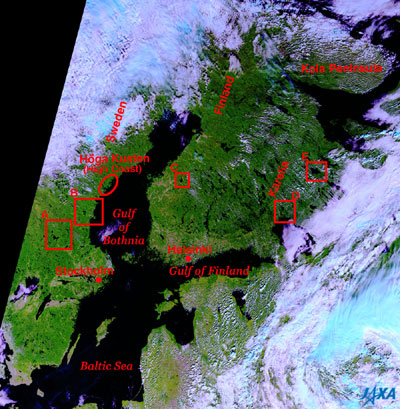
Figure 1 shows the coastal countries around the Baltic Sea during September of 2003. The Baltic Sea appears black in center, and extends north to the Gulf of Bothnia , and east to the Gulf of Finland. Sweden, Finland, Estonia, Latvia, Lithuania, Russia (an enclave) and Poland surround the Baltic Sea clockwise from the west. An area called the Baltic Shield (*) reaches from southern Norway to Sweden, Finland and a part of Russia (Kola Peninsula and Karelia district). It consists of stable block made in the Precambrian period (after the birth of the Earth 4.6 billion years ago to around 600 million years ago). Metamorphic rocks that some believe to be 3.5 billion years old and the world's oldest class were found in the Kola Peninsula. Since the Cambrian (from 580 million years ago to 510 million years ago) it has eroded without taking crustal changes, and has become flat. Then it came to have the geographic features similar to the Canadian Shield with many lakes that have been eroded by wind, rain and glaciers for many years. Many gigantic impact craters also remain in this area, as you can see in this 250 m resolution GLI image. Every crater of A - E became a lake. The following table shows the order and era each crater was created .
The Scandinavian Mountains connected to the north-west side of Baltic Shield were formed together with the U.K., Ireland and the Appalachian Mountains on the east coast of North America during the Precambrian an into to the Devonian (about 600 million years ago to 360 million years ago) by the Caledonian Orogeny. The Caledonian Orogeny caused the collision between the North American plate and Eurasian/African plates. However, since the Permian period (300 million years ago to 250 million years ago), both plates began to separate, and the Atlantic Ocean was formed and continues to expand at a rate of about 3 cm a year. The area of Northern Europe was covered in a thick glacier during the ice age from 2 million years to 10,000 years ago. The glacier began to retreat about 12,000 years ago. The crust floats on the mantle with a larger density and keeps its balance. This status is called “isostacy,” then the crust that lost weight of a glacier began to uplift. Original uplift speed was 9 cm annually, and continues at a rate of 1 cm a year in the Gulf of Bothnia. It takes 15,000 years to 20,000 years to restore balance. (*) The Shield is a flat, extensive area composed primarily of Precambrian rocks. If viewed as a whole, the center is a bit higher, and the height gradually decreases in a radial direction. It resembles the shape of a shield used by knights in medieval times, hence it was named "Shield." There are the Canadian Shield, the Baltic Shield, etc.
Related sites: Appendices: Influence of an uplift: As the place where an uplift is, two are given in Sweden. One is “Höga Kusten” (HighCoast) located on the west shore of the Gulf of Bothnia. There you can see complicated and strange geographical features such as many islands, inlets, lakes, flat hills 350 m high above the sea level generated by glaciating, retreat of glaciers and the appearance of new lands generated by an uplift. In addition, a good example of the trade network of the Vikings during the eighth and ninth centuries, Birka and Hovgården are registered with the World Cultural Heritage and are located on two islands in LakeMälaren to the west of Stockholm. LakeMälaren was connected to the sea in those days, and prospered as a center of international trade during the Vikings eighth century , but it became extinct by the end of tenth century because big ships could not gain access there due to an uplift. In Finland they also had to move ports in the sea side in Pori located 230 km northwest of Helsinki and in Vaasa 180 km north of Pori. The Vikings and their activity coverage: It was comparatively warm during the time of the Vikings (800-1050). The Vikings left Denmark, Sweden and Norway, and sailed to the European coasts by small ships and carried out active trade. The Danish Vikings arrived at the Mediterranean Sea, the Norwegian Vikings discovered Iceland in 860 and settled there. Some Vikings reached Greenland and North America. The Swedish Vikings reclaimed the following two trade routes by the end of ninth century . Route 1. Go down the Dnieper from near the Baltic Sea, enter the Black Sea, and continue to Constantinople (Istanbul), the capital of Byzantine Empire. Route 2. Go down the Volga from near the Baltic Sea, enter the Caspian Sea, and continue to Baghdad, the capital of an Arab kingdom via Baku. |
|||||||||||||||||||||||||||||||||||||||||||


