Seen from Space 2004
Shield memorizing impact craters: Labrador Peninsula, Canada
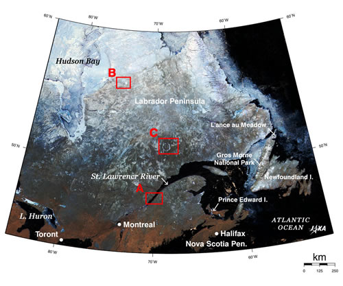
Figure 1 depicts Labrador Peninsula in Northeast Canada in early spring of last year. The nothern area of around 50 degrees north was still covered with snow and ice . This image covers Hudson Bay in the upper left, a part of the Great Lakes in the lower left, the Gulf of Saint Laurence, Nova Scotia Peninsula and Prince Edward Island (made famous in the novel and the movie "Anne of Green Gables") in the lower right, and Newfoundland Island and the Atlantic Ocean on the right. Labrador Penisula is a part of the Canadian Shield (*1), a plateau of granite made 600 million years ago (around the end of Precambrian Era), and is characterized geographically by many lakes formed by erosion from wind, rain and glaciers over a long time. Many gigantic impact craters also remain in this area (*2), and you can find the following craters in this GLI image. (Larger pictures will appear when you click boxed areas A to C.) Some craters became lakes and some were covered with vegetation, depending on when they were created, its geology, subsequent weathering and erosion, etc. The following table shows the craters in the order of created era.
The Manicouagan crater (C above) consists a crater chain together with Rochechouart crater (25 km in diameter) in France and Saint Martin crater (40 km in diameter) in Manitoba, Canada (*3). "Crater chain" means a chain of craters made by sequential impacts of the pieces broken up of original one terrestrial body like the impact of Comet Shoemaker-Levy 9 on Jupiter in July 1994. There are some crater chains on the Moon and Ganymede, Jupiter's satellite. "Tableland" in Gros Morne National Park on the west coast of Newfoundland Island is a 600 m high plateau made of p e ridot that was once a part of the upper mantle exposed on the ground surface after breaking through the crust of the ocean floor when the North American Plate and Eurasian/African Plate collided 450 million years ago (the Ordovician). This is one of the main reasons why Gros Morne National Park has been designated a World Heritage Site by UNESCO (the United Nations Education, Scientific, and Cultural Organization). At L'Anse aux Meadows (meaning cove at meadows) National Historic Site, located on the northen end of Newfoundland Island and declared a UNESCO World Heritage Site, there are archaeological remains of activities of native people around 6,000 years ago and of a settlement of Viking people around 1,000 years ago, or about 500 years before Columbus reached the West Indian Islands. (*1) The Shield is a flat, extensive area composed primarily of precambrian rocks. If viewed as a whole, the center is a bit higher, and the height gradually decreases in the radial direction. It thus resembles the shape of a shield used by knights in medieval times and is called "Shield." In addition to the Canadian Shield, there is also the Baltic Shield and others. Related sites (*2) Earth Impact Database operated by the University of New Brunswick in Canada (*3)News release of the University of Chicago
|
|||||||||||||||||||||||||||||||||||||