About CH4Rice Project
Background
Methane (CH₄) is a powerful greenhouse gas, and emissions from rice paddies are estimated to account for approximately 8% of total global anthropogenic methane emissions. Reducing methane emissions can make an effective contribution to rapid climate change mitigation. Methane emissions from rice paddies can be reduced through practices such as Alternate Wetting and Drying (AWD).
The CH4Rice project was approved at the SAWG meeting during APRSAF-28 in Hanoi, Vietnam in November 2022. It has two primary aims: contributing to climate change mitigation, and promoting sustainable agriculture. The project seeks to achieve these goals by encouraging the adoption of AWD and other water-saving irrigation techniques. These techniques can improve water efficiency, and reduce methane emissions from rice paddies by shortening the inundation period—that is, reducing the amount of time the crop remains submerged.
CH4Rice seeks to integrate satellite and in situ data, together with field observations, to develop methodologies for monitoring water levels across large rice-growing areas. These methodologies are intended to underpin improved water management practice, support measurable reductions in methane emissions, and enable the generation of carbon credits for use within national Monitoring, Reporting, and Verification (MRV) systems.
Project Leader: Vietnam National Space Center (VNSC)Objectives and Expected Outcomes
Accurate assessment of CH4 emissions is essential for sustainable rice cultivation. Accordingly, the CH4Rice project aims to:
- Improve water management by promoting efficient irrigation techniques such as Alternate Wetting and Drying (AWD).
- Develop Monitoring, Reporting, and Verification (MRV) approaches for methane emissions to support carbon credit schemes and climate change mitigation efforts.
- Promote and participate in regional and global sustainable agriculture initiatives, including CEOS, SDG Goals 2 & 13, GEOGLAM/Asia-RiCE, and AOGEO.
Implementation Approach
To achieve these objectives, CH4Rice focuses on:
- Developing methodologies for monitoring water inundation and methane emissions from rice paddies using satellite, in situ, and field observation data.
- Sharing data, tools, and knowledge to strengthen multilateral collaboration.
- Promoting dialogue with stakeholders and policymakers by presenting findings to inform national policies.
- Aligning with related projects, including SAFE Agromet, and Rice Monitoring.
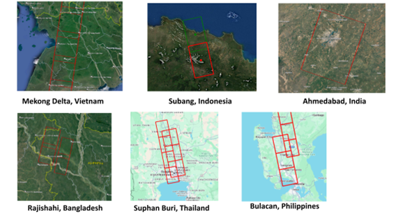
Study Areas and Data Collection
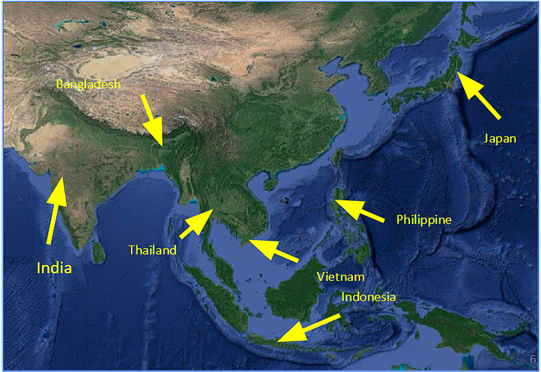
The project currently utilises full-pol L-band ALOS-2 PALSAR-2 and ALOS-4 PALSAR-4 radar imagery, alongside in situ water-level measurements across multiple ‘super sites’ in key rice-producing regions:
BRIN Indonesia: Subang
GISTDA Thailand: Suphan Buri
ISRO India: Nawagam
JAXA Japan: Miyagi, Akita, Niigata, Ibaraki
PhilSA Philippines: Bulacan
PUST Bangladesh: Rajshahi
VNSC Vietnam: Mekong Delta (An Giang, Bac Lieu)
Selected CH4Rice Study Sites
There are now four CH4Rice study sites in Japan, shown below:

Key Actions and Way Forward
Water Inundation Monitoring
- Conducting field surveys and installing in situ water level sensors at study sites.
- Comparing in situ data with satellite radar images to refine monitoring algorithms.
- Expanding research across regions and publishing findings as scientific evidence.
Methane Emission Estimation
- Deploying low-cost gas sampling systems to measure methane flux at study sites.
- Enhancing data collection to improve methane emission modelling.
Data and Tool Sharing
- Providing full-pol ALOS-2 and ALOS-4 data to participating study sites.
- Developing and sharing monitoring tools, platforms, and user training materials.
- Improving water-level sensor calibration for a standardised ground-based database.
Stakeholder Engagement and Policy Impact
- Publishing research papers to provide scientific evidence for policy and real-world applications.
- Engaging public and private sector stakeholders to explore practical implementation pathways.
Future Plans
CH4Rice will continue to:
- Conduct field surveys and expand in situ monitoring networks to validate satellite-based methane and water inundation products across all super sites.
- Integrate multi-SAR data sources, including ALOS-2/ALOS-4 (L-band), and emerging missions to enhance mapping capability and observation frequency.
- Engage with public and private sector stakeholders to integrate satellite-based methodologies into carbon credit frameworks and guidance documents (e.g. Verra, Gold Standard, JCM), in coordination with donor agencies.
- Collaborate with private sector partners on emission trading initiatives and operational deployment pathways.
- Advance low-cost IoT sensor development and deployment, in collaboration with technology partners and research institutions, to improve the scalability and reliability of in situ methane and water-level monitoring.
- Hold a coordination meeting in early 2026 to consolidate the results and accelerate joint activities following submission of special issue papers.
Call for Papers
The special issue editors are calling for papers on "Assessment of Methane Emission from Rice Paddies and Water Management Using Remote Sensing Technology" for a special issue of Remote Sensing (ISSN 2072-4292).
The submission schedule for CH₄Rice-related contributions has been extended, with multiple manuscripts from participating institutions currently in preparation. A technical coordination meeting will follow the submission phase to review the submitted papers and discuss pathways for implementation of the project’s objectives.
Please see the following link for formal details and submission information;
https://www.mdpi.com/journal/remotesensing/special_issues/01TSKHAZT7/