Dataset
Global PALSAR-2/PALSAR/JERS-1 Mosaics and Forest/Non-Forest Maps
1. Updates
| Apr. 30, 2026 |
PALSAR global mosaic datasets from 2007 to 2010 were updated to Ver.2.6.0 Global 25m Resolution PALSAR-2/PALSAR Mosaic Dataset Description has been updated (Ver. 2.6.0a)
|
|---|---|
| Apr. 21, 2026 | PALSAR-2 global mosaic datasets from 2015 to 2019 were updated to Ver.2.6.0 |
| Apr. 09, 2026 | PALSAR-2 global mosaic datasets from 2020 to 2024 were updated to Ver.2.6.0 |
| Mar. 11, 2026 |
PALSAR-2 global mosaic map in 2025 was released as Ver.2.6.0. Global 25m Resolution PALSAR-2/PALSAR Mosaic Dataset Description has been updated (Ver. 2.6.0) |
| Mar. 31, 2025 |
PALSAR-2 global mosaic map in 2024 was released as Ver.2.5.0. Global 25m Resolution PALSAR-2/PALSAR Mosaic Dataset Description has been updated (Ver. 2.5.0) |
| Nov. 15, 2024 |
JERS-1 SAR global mosaic datasets were updated to Ver. 2 Global 25m Resolution JERS-1 SAR Mosaic Dataset Description has been updated (Ver. 2.0.0) |
| May 17, 2024 |
PALSAR-2 global mosaic map in 2023 was released as Ver.2.4.0. Global 25m Resolution PALSAR-2/PALSAR Mosaic Dataset Description has been updated (Ver. 2.4.0) |
| Aug. 10, 2023 |
PALSAR global mosaic map in 2008 and 2009 was updated as Ver.2.3.0. Global 25m Resolution PALSAR-2/PALSAR Mosaic Dataset Description has been updated (Ver. 2.3.0a) |
| May 31, 2023 |
PALSAR global mosaic map in 2007 and 2010 was updated as Ver.2.3.0.
Global 25m Resolution PALSAR-2/PALSAR Mosaic Dataset Description has been updated (Ver. 2.3.0) |
| Apr. 28, 2023 |
PALSAR-2 global mosaic map in 2022 was released and updated to Ver.2.2.0. Global 25m Resolution PALSAR-2 Mosaic Dataset Description has been updated (Ver. 2.2.0) |
| Mar. 10, 2023 |
The PALSAR-2 global mosaic datasets have been certified as fully compliant with CEOS-ARD threshold requirements for Normalised Radar Backscatter (NRB) |
| Sep. 13, 2022 |
Replaced 33 tiles of the 2020 PALSAR-2 global mosaic datasets and updated to Ver.2.1.2.
The replaced tiles are as follows:
N70E165, N70E166, N70E167, N70E168, N70E169, N70E170, N70E171, N70E172, N70E173, N70E174, N70E175, N70E176, N70E177, N70E178, N70E179, N71E165, N71E166, N71E167, N71E168, N71E169, N71E170, N71E171, N71E172, N71E173, N71E174, N71E175, N71E176, N71E177, N71E178, N71E179, N72E177, N72E178, N72E179 Global 25m Resolution PALSAR-2 Mosaic Dataset Description has been updated (Ver. 2.1.2)
|
Jul. 22, 2022 |
PALSAR-2 global mosaic datasets from 2015 to 2021 were updated to Ver.2.1.1.
Global 25m Resolution PALSAR-2 Mosaic Dataset Description has been updated (Ver. 2.1.1). |
| Jun. 21, 2022 |
PALSAR-2 global mosaic datasets from 2015 to 2021 were updated to Ver.2.1.0 Global 25m Resolution PALSAR-2 Mosaic Dataset Description has been updated (Ver. 2.1.0). Global 25m Resolution PALSAR-2 Global Forest/Non-forest Map Dataset Description has been updated (Ver. 2.0.0a). Global 25m Resolution PALSAR Mosaic and Forest/Non-Forest Map (FNF) Dataset Description has been updated (Ver. O). |
| Apr. 12, 2022 |
PALSAR-2 global mosaic datasets in 2015 and 2016 were updated, and 2021 was released. Forest/non-forest maps in 2017, 2018, 2019 and 2020 were released. The dataset description document was updated and divided into the global mosaic dataset and the forest/non-forest map dataset. |
| Mar. 22, 2022 |
PALSAR-2 global mosaic datasets in 2017 and 2018 were updated. |
| Feb. 28, 2022 |
PALSAR-2 global mosaic map in 2019 and 2020 were updated. The dataset description document has been updated (Ver. L). Forest/non-forest maps are not included in 2019 and 2020 dataset, yet(Coming soon).
|
| Apr. 08, 2021 |
PALSAR-2 global mosaic map in 2020 was released. The dataset description document has been updated (Ver. K). Forest/non-forest map is not included in 2020 dataset, yet. |
| Mar. 31, 2021 |
PALSAR-2 global mosaic map in 2019 was released. The dataset description document has been updated (Ver. J). Forest/non-forest map is not included in 2019 dataset, yet. |
| Dec. 27, 2019 |
PALSAR-2 global mosaic map in 2018 is released. The dataset description document has been updated (Ver. I). Forest/non-forest map is not included in 2018 datasets, yet. |
| May 07, 2018 | PALSAR-2 global mosaic and forest/non-forest map
(2017 global dataset, and low resolution dataset of 2015-2017) are released. The dataset description document has been updated (Ver. H). |
| Apr. 27, 2018 | The dataset description document has been updated (Ver. G). |
| Apr. 19, 2018 | PALSAR-2 global mosaic and forest/non-forest maps (2015 and 2016 datasets around Japan) are released. The dataset description document has been updated (Ver. F). |
| Oct. 2, 2017 | The dataset description document has been updated (Ver. E). |
| Jun. 20, 2017 | Replaced 9 tiles of the 2015 dataset. The replaced tiles are as follows: N16E145,N16E146,N17E145,N17E146,N18E145,N18E146,N19E145,N19E146,N20E145 |
| May 24, 2017 | About data utilization has been added. |
| Apr. 27, 2017: | PALSAR-2 global mosaic and forest/non-forest map in 2016 are released. Reprocessed version of PALSAR-2 global mosaic and forest/non-forest map in 2015 are released. Dataset description document has been updated (Ver.D).
* The data around Japan will be available in the near future. |
| Jan. 11, 2017 | JERS-1 SAR yearly mosaic for tropical regions from 1993 to 1998 are released. The dataset description document has been updated (Ver. C). |
| Oct. 31, 2016 | JERS-1 SAR global mosaic in 1996 are released. Dataset description document has been updated (Ver. B). |
| May 10, 2016 | Dataset description document has been updated (Ver. A). |
| Apr. 6, 2016 | (Correction) of figure 1 used in [Global 25m Resolution PALSAR-2/PALSAR Mosaic and Forest/Non-Forest Map] |
| Mar. 28, 2016 | PALSAR-2 global mosaic and forest/non-forest map for Japan in 2015 are released. |
| Mar. 28, 2016 | Low resolution forest/non-forest maps (0.25 degrees and 1km) are released. |
| Jan. 25, 2016 | PALSAR-2 global mosaic and forest/non-forest map in 2015. * Data for Japan (using polarimetry mode) will be available soon. |
| Jan. 16, 2014 | PALSAR global mosaic and forest/non-forest maps in 2007, 2008, 2009 and 2010. |
2. Overview
To improve understanding of and responses to the impacts of global environmental changes, timely and consistent monitoring of the global land cover is essential. Global monitoring with satellite remote sensing is one of the most effective approaches to detect land surface changes, such as deforestation and forest degradation, as satellites can provide wall-to-wall observations covering wide areas periodically. The long wavelength (L-band) Synthetic Aperture Radars (SAR) on JERS-1,ALOS and ALOS-2 are particularly sensitive to vegetation structure and can observe the land surface even under clouds, and as such, are particularly useful to provide information about forest changes in the tropical regions.
Global L-band SAR mosaics
The global 25m resolution SAR mosaics and forest/non-forest maps are free and open annual datasets generated by JAXA and GAMMA Remote Sensing using the L-band Synthetic Aperture Radar sensors on the Advanced Land Observing Satellite-2 (ALOS-2 PALSAR-2), the Advanced Land Observing Satellite (ALOS PALSAR) and the Japanese Earth Resources Satellite-1 (JERS-1 SAR).
The mosaics have been created by assembling long paths of SAR backscatter images observed through JAXA’s global Basic Observation Scenario for PALSAR and PALSAR-2. Correction of geometric distortions specific to SAR (ortho-rectification) and topographic effects on image intensity (radiometric slope correction) are applied to accommodate image analysis without the need for further processing. The mosaics are provided as Gamma-0 backscatter, in geographical (lat/long) coordinates with a pixel spacing of 0.8 arc seconds (approximately 25 meters at the Equator). The temporal interval of the mosaics is annual with PALSAR-2 mosaics available for the 2015-2024 time period and PALSAR mosaics for 2007-2010. The JERS-1 SAR mosaic dataset is also available for 1992-1998.
A set of re-processed global 25m resolution PALSAR-2 mosaics for the period 2015 to 2020 (Ver. 2) were released together with a newly created global PALSAR-2 mosaic for the years after 2021. The annual (2007-2010) PALSAR mosaic dataset was also reprocessed according to the new approach and product format. The JERS-1 global mosaic dataset was generated by Gamma Remote Sensing, under special commission by JAXA EORC. The new mosaics have improved geometric performance. PALSAR-2 and PALSAR mosaics applied radiometric balancing between adjacent paths to make the products seamless. The differences in processing methods and output formats compared to previous versions are as follows;
- GDAL based mosaicking process to improve absolute geometric accuracy and processing speed.
- Products developed to comply with Combined CEOS Analysis Ready Data (CEOS-ARD) for Synthetic Aperture Radar Product Family Specifucation (PFS).
- Only data from the one year in question are used for each annual mosaic, and hence no gap-filling using data from previous years in case of gaps in the annual global coverage.
- Radiometric balancing between adjacent paths is applied to land data of PALSAR-2/PALSAR only.
- The backscatter may differ from pass to pass in the ocean due to the lack of radiometric balancing, and in some land areas due to changes in backscattering intensity caused by changes in land cover, soil moisture, or seasonal variations.
- Due to the geometric accuracy improvement, slight misalignment may be observed when the new global 25m resolutions PALSAR-2/PALSAR mosaic dataset (Ver.2) is overlaid on the past PALSAR-2/PALSAR/JERS-1 mosaic datasets.
For details on the re-processed PALSAR-2/PALSAR and JERS-1 datasets, please see "Global 25m Resolution PALSAR-2/PALSAR Mosaic Dataset Description" and "Global 25m Resolution JERS-1 SAR Mosaic Dataset Description". For the past PALSAR-2/PALSAR/JERS-1 SAR mosaic datasets, please see the "Global 25m Resolution PALSAR Mosaic and Forest/Non-Forest Map (FNF) Dataset Description".
Global Forest/Non-Forest maps
The global forest/non-forest maps (FNF) were generated by a Random Forest machine learning-based classification method, with the re-processed global 25m resolution PALSAR-2 mosaic dataset (Ver. 2) as input. Here, the "forest" is defined as the tree covered land with an area larger than 0.5 ha and a canopy cover of over 10 %, in accordance with the FAO definition of forest. The classification results are presented in four categories, with two categories of forest areas: forests with a canopy cover of 90 % or more and forests with a canopy cover of 10 % to 90 %, depending on the density of the forest area.
The previous version of the global forest/non-forest maps - currently the case for the PALSAR FNF maps - were published in three categories: forest, non-forest, and water. A threshold method was used to determine forest/non-forest for each year, which caused discontinuities when examining the same area over time, and changes could not be accurately captured.
Therefore, in the newly released (Ver 2) version, data for the past year is used in addition to the data for the target year to be created. For example, when creating the 2020 FNF, the global 25m resolution mosaics of 2019 and 2020 are stacked and used as input data for classification. When stacked, the target year mosaic is weighted 3 times more than the past year's mosaic. In this way, the stacked data can represent the forest change by retaining the effect of the target year on the areas where the forest has changed.
Accuracy validation of the classification results was conducted for the four-category case and for the three-category case where the two forest areas were integrated. The results indicate that the overall accuracy was at least 86 % for 3 categories and 76 % for 4 categories for four years from 2017 to 2020. Accuracy thus improved by 5-10 % or more compared to the previous version. Figure 1 shows global mosaic images and forest/non-forest maps, and Figure 2 shows an example of Borneo island. Please refer to the "Global 25m Resolution PALSAR-2 Forest/Non-forest Map Dataset Description" document for details on the classification method. JAXA plans to update the FNF classification algorithm to improve its accuracy. Any comments or requests for the datasets are welcome.
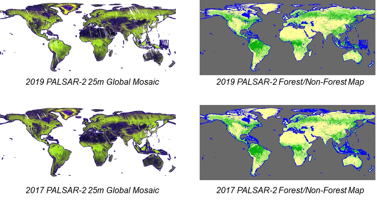
Figure 1: PALSAR-2 global mosaics and forest/non-forest maps.
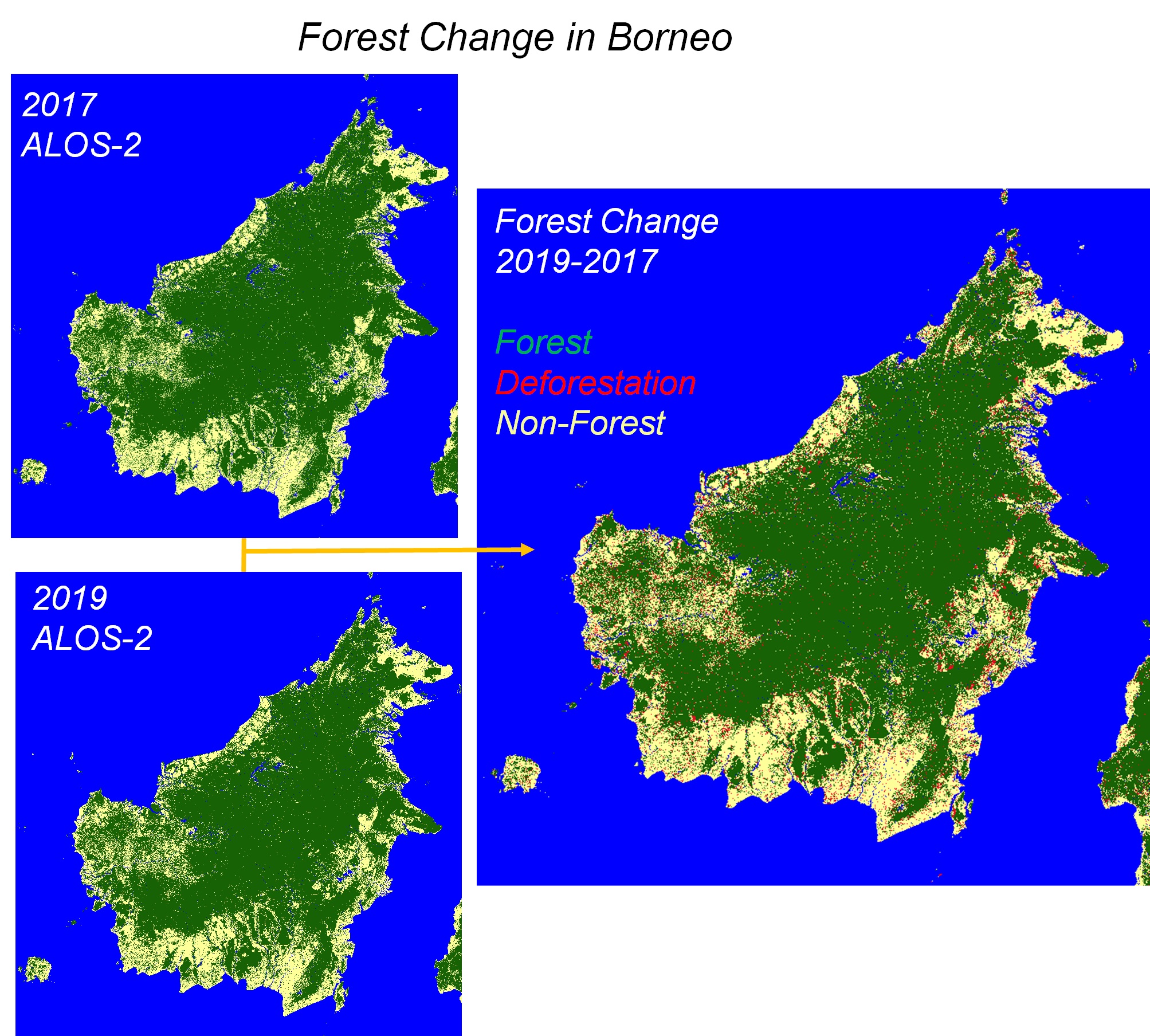
Figure 2: Loss of forest cover (red areas in the map) in Borneo Island from 2017 to 2019.
3. Dataset description
- ALOS-2 PALSAR-2 and ALOS PALSAR: Sigma-SAR IMAGE (for strip processing) and GDAL (for mosaicking)
- JERS-1 SAR: GAMMA InSAR software (www.gamma-rs.ch) (for strip processing) and GDAL (for mosaicking)
- Ver.2 Datasets: Cloud Optimized GeoTIFF + XML metadata (in compliance with Combined CEOS-ARD for Synthetic Aperture Radar PFS (Ver.1.0))
- Other Datasets: binary image file + header file
- 0.8 arc seconds (approx. 25 m at the Equator)
- 1 x 1 degree tiles (4500 x 4500 pixels)
- ALOS-2 PALSAR-2 mosaics and FNF maps: 2015, 2016, 2017, 2018, 2019, 2020, 2021, 2022, 2023, 2024, 2025
- ALOS PALSAR mosaics and FNF maps : 2007, 2008, 2009, 2010
- JERS-1 SAR mosaics: 1992, 1993, 1994, 1995, 1996, 1997, 1998, 1992-1998
- Ortho and slope corrected Gamma-0 backscattering coefficient (ALOS-2 PALSAR-2 and ALOS PALSAR: HH and HV polarization, JERS-1 SAR: HH polarization)
- Forest/non-forest map
- Observation date image
- Local incidence angle image
- Processing mask information image
For details, please see the following dataset descriptions;
4. Download
Please register your information from the following URL to download the dataset. Your email address is required.
The dataset download site is
5. About data utilization
About decompression of data
The downloaded file is compressed into one file by zip or tar.gz and software may be necessary for this decompression. For example, 7-Zip is available as free software.
Displaying and using data
To display and use the "Global PALSAR-2/PALSAR/JERS-1 Mosaic and Forest/Non-Forest map", image processing, remote sensing or GIS software are required.
Public open GIS and image processing software that can be used include, for example,
Please note that the software above are mentioned as examples only, and their utility cannot be guaranteed by JAXA. Please understand that JAXA can not answer any questions about the software.
Please refer to these as "JAXA Global PALSAR-2/PALSAR/JERS-1 Mosaic and Forest/Non-Forest maps".6. Note for data use
This dataset is available to use with no charge under the "Terms of Use of Research Data".
To publish images using the dataset as it is, please display "©JAXA" in the image.
7. Contact
ALOS-2/ALOS Science Project
Earth Observation Research Center (EORC)
Japan Aerospace Exploration Agency (JAXA)
E-mail: aprojectjaxa.jp
8. References
- Takeo Tadono, Masato Ohki, Takeshi Motohka, Ake Rosenqvist, and Shinichi Sobue, "Advanced Land Observing Satellite-2 “DAICHI-2” (ALOS-2): Overview and operational status," IEEE Geoscience and Remote Sensing Magazine (Early Access), February 2025 DOI: 10.1109/MGRS.2025.3535720.
- Masanobu Shimada, Takuya Itoh, Takeshi Motooka, Manabu Watanabe, Shiraishi Tomohiro, Rajesh Thapa, and Richard Lucas, "New Global Forest/Non-forest Maps from ALOS PALSAR Data (2007-2010)", Remote Sensing of Environment, 155, pp. 13-31, December 2014. DOI=10.1016/j.rse.2014.04.014.
- Masanobu Shimada, and Takahiro Ohtaki, "Generating Large-Scale High-Quality SAR Mosaic Datasets: Application to PALSAR Data for Global Monitoring", IEEE Journal of Selected Topics in Applied Earth Observations and Remote Sensing 3(4):637 - 656, January 2011. DOI: 10.1109/JSTARS.2010.2077619
- New global 25m-resolution PALSAR mosaic and forest/non-forest map (2007-2010) - version 1: (Jan. 16, 2014)
- Generation of Global Forest/Non-forest map Using ALOS/PALSAR: (Oct. 21, 2010)
- PALSAR 10m mosaic: (Nov. 4, 2010)
- CEOS Analysis Ready Data
- CARD4L. Product Family Specification: Normalised Radar Backscatter, version 5.5
- CEOS-ARD. Product Family Specification: Synthetic Aperture Radar, version 1.0
9. Old Version
PALSAR 10m Mosaic Data
- Porto Velho, Rondonia, Brazil
- Riau, Indonesia
- Congo River