Dataset
New global 25m-resolution PALSAR mosaic and forest/non-forest map
(2007-2010) - version 1
1. Summary
Japan Aerospace Exploration Agency, JAXA, has produced the 4 year-25m spacing global PALSAR mosaics, that Advanced Land Observing Satellite (ALOS)/ Phased array Type L-band SAR (PALSAR) collected globally from 2007 to 2010 using the accurate SAR processing1,2,3). JAXA also produced the first version of the 10m spaced global forest/non-forest map experimentally 2010 4,5). This time, we have produced the new forest/non-forest map (FNF-map) (validation version) by precisely evaluating the mosaic data regionally and temporally and comparing with the optical data (Google Earth images) and ground truth data6). Fig. 1 shows the FNF map of 2007, 2008, 2009, and 2010. FNF-map is the important geophysical information on investigating the temporal forest land change, terrestrial causes on global warming, and proceeding the activity on Reducing the Emission from Deforestation and forest Degradation plus (REDD+). This map was validated within the accuracy of 90% in comparison with three types of the ground truth data.
JAXA allows everyone to downloading the 25m data freely in order to utilize the L-band SAR data for the forest application. And Low-resolution version "FNF100" is also released at the same time. FNF100 is 100m resolution Forest/Non-Forest data reduced from the 25m original data.
The above accuracy was obtained from the random analysis between the truth data and the FNF globally. Since the forest definition depends on the country, this FNF-map needs to be improved more.
We are looking forward to hearing the comment and the request for improving this FNF in future.
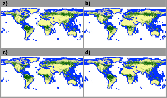
Fig. 1: New Forest/Non-forest map ( a) 2007, b) 2008, c) 2009, d) 2010 )
2. Data details
One unit Data contains PALSAR HH, HV backscatter,forest/non-forest map, local incidence angle, mask info. (layover, shadowing, ocean flag, effective flag, void flag), total dates from the launch. SAR backscatter data is slope corrected and ortho-rectified using the SRTM3, and the radiometrically calibrated7).
| Characteristic | Description |
|---|---|
| Unit | 1 degree latitude-longitude geographical unit |
| Reference location for each tile | Latitude and longitude of north west corner |
| Coordinate system | Latitude-longitude coordinate Datum: ITRF97 Ellipsoid: GRS80 |
| Spacing | 0.8 arcsec unit providing the spacing at 25m |
| Resolution of SAR image | 36 m (azimuth) × 20 m (range) |
| Number of pixels and lines | 4500 pixels × 4500 lines |
| Data volume | 40.5 MB (per tile) |
| Data file format | Unsigned 16bit Raw + Envi Header |
| Contents | Normalized radar cross-section, gamma-naught in HH and HV, mask information (ocean flag, effective area, void area, layover, shadowing), local incidence angle, total dates from the ALOS launch (1:30:Jan. 24, 2006:UTC) |
| Mask file format | 0: NoData 50: Sea and Water 100: Layover 150: Shadow 255: Land |
| No of tiles per year | 2007: 27062, 2008: 27163, 2009: 27703, 2010: 27923 |
| Characteristic | Description |
|---|---|
| Unit | 10 degree latitude-longitude geographical unit |
| Reference location for each tile | Latitude and longitude of north west corner |
| Coordinate system | Latitude-longitude coordinate Datum: ITRF97 Ellipsoid: GRS80 |
| Spacing | 3.2 arcsec unit providing the spacing at 100m |
| Number of pixels and lines | 1125 pixels × 1125 lines |
| Data volume | 2.5 MB (per tile) |
| Data file format | 8bit Raw + Envi Header |
| Contents |
|
| Mask file format | 0: NoData 50: Sea and Water 100: Layover 150: Shadow 255: Land |
| No of tiles per year | 2007: 367, 2008: 369, 2009: 376, 2010: 370 |
3. Data download method
To download the PALSAR mosaic and FNF data, first, user registration is necessary through the following URL (your email address is necessary).
After accessing the URL and filling the questions, pre-registration will be conducted (This does not mean that the registration is complete). Then, you may receive the URL for the final registration.
After this process, you can download the data from the following URL.
4. Copyright
It is prohibited to re-distribute the PALSAR mosaic and FNF data as is that users download in accordance with Section 3. However, users can use the PALSAR mosaic and FNF data as is for research and publish thesis or research report, and modify the PALSAR mosaic and FNF data and publish or re-distribute such modified data. In such cases, data source shall be appropriately acknowledged as follows;
In case of use of the PALSAR mosaic and FNF data as is:
JAXAIn case of users modify the PALSAR mosaic and FNF data and use such modified data:
Original data provided by JAXA
It is prohibited to use the PALSAR mosaic and FNF data for commercial, profit-making purposes without JAXA's consent. If users wish to use the PALSAR mosaic and FNF data for such purposes, please make contact to JAXA in accordance with Section 5.
5. Contact
Japan Aerospace Exploration Agency, Earth Observation Research Center, ALOS-Gr
E-mail: aprojectjaxa.jp
6. Reference
1) K&C mosaic home
https://www.eorc.jaxa.jp/ALOS/a/en/dataset/kc_mosaic_e.htm
2) PALSAR 10m mosaic:
https://www.eorc.jaxa.jp/ALOS/a/en/dataset/fnf/pal_10m_mosaic_e.htm
3) M. Shimada, O. Isoguchi, T. Tadono, and K. Isono, "PALSAR Radiometric and Geometric Calibration," IEEE Trans. GRS, vol. 47, no. 12, pp.3915-3932, Dec 2009.
4) M. Shimada and T. Otaki, "Generating Continent-scale High-quality SAR Mosaic Datasets: Application to PALSAR Data for Global Monitoring," IEEE JSTARS Special Issue on Kyoto and Carbon Initiative, vol. 3, Issue 4, 2010, pp.637-656.
5) Shimada, M.; Isoguchi, O.; Motooka, T.; Shiraishi, T.; Mukaida, A.; Okumura, H.; Otaki, T.; Itoh, T., "Generation of 10m resolution PALSAR and JERS-SAR mosaic and forest/non-forest maps for forest carbon tracking," Geoscience and Remote Sensing Symposium (IGARSS), 2011 IEEE International , vol., no., pp.3510,3513, 24-29 July 2011
doi: 10.1109/IGARSS.2011.6049978
6) Masanobu Shimada, Takuya Itoh, Takeshi Motooka, Manabu Watanabe, Shiraishi Tomohiro, Rajesh Thapa, and Richard Lucas, "New Global Forest/Non-forest Maps from ALOS PALSAR Data (2007-2010)," Remote Sensing of Environment, accepted April 4, 2014
DOI=10.1016/j.rse.2014.04.014.
7) Global forest/non-forest:
https://www.eorc.jaxa.jp/ALOS/a/en/dataset/fnf/forestmap_oct2010_e.htm