Calibration and Validation
Which calibration factor of ALOS-2 standard products should I use?
+
The calibration factor you should use depends on the observation mode and the data processing day (product ordering time).
For details, please refer to the following.
How can I know the data processing day of ALOS-2 standard products?
+
Please check the second line of "summary.txt" file.
How can I refer the Path Number in ALOS-2 standard product?
+
There is no path number information the "summary.txt" file of ALOS-2 standard product.
Path number information is described in the kml file which is included in the same directory.
In addition, it is also available to find path number by using following formula:
PathNumber = mod(14*OrbitAccumulation+24,207)
Parameter "OrbitAccumulation" can be acquired from Scene ID .Scene ID can be obtained from product file name.
For example orbit accumlation number is written below (In case of Image file):
IMG-HH-ALOS2182180613-171007-FBDR1.1__A
Red colored numbers show "orbit accumulation number".
How can I convert to sigma naught using PALSAR-2 "Level 3.1" standard product?
+
PALSAR-2 level 3.1 standard product is processed by dynamic range compression, which changes the brightness range for each area to improve the "visibility" of the image.
Therefore, it cannot be converted to backscatter coefficients.
Please use L1.1, L1.5, or L2.1 products for research purposes.
Global PALSAR-2/PALSAR/JERS-1 Mosaic and Forest/Non-Forest Map
How can I display the product?
+
Where does the latitude / longitude in the filename of the Global SAR Mosaic product and the Forest/Non Forest Map product refer to in the pixel?
+
The latitude and longitude in the file name means the coordinates of the upper left corner of the upper left pixel of the image.
Regarding the numerical value of the Global SAR Mosaic product, is it the average of the data acquired in the year?
+
No. The numerical value of the product is not the average but single observed value in the year. You can find the observation date in "observation date" file included in "tar.gz" file.
The detail is described in the following document.
Could you provide higher resolution PALSAR-2/PALSAR/JERS-1 product than the product on the web site?
+
The web site provides only free-of-charge products of ALOS series missions.
Please contact the following data provider if you wish to have higher resolution product.
Is the same classify method used for the Forest/Non Forest classification every year?
+
Yes. Basically, all of the Forest/Non Forest Map product is created by the same thresholding method.
Threshold values are tuned depending on observation period and area.
For details of the method, please refer to the
"References".
Due to the reprocess of the source data, dataset of 2015 was updated on April 2017. Please use the latest version.
The Forest/Non Forest Map product contains four numbers (from 0 to 3). What is the meaning of these numbers?
+
Their meaning is as follows.
0: No data
1: Forest area
2: Non-forest area
3: Water area
For details, please refer to the following.
Let me know about the definition of the forest on the Forest/Non Forest Map product.
+
Same as the definition by FAO. That is, land spanning more than 0.5 hectares with trees and a canopy cover of more than 10 percent.
Are there any manuals of Let's SAR tool?
+
Regarding to Let's SAR tool, there are 2 kinds of manuals.
A. The video tutorial is available from following URL:
https://youtu.be/V_wEvf3eHQc
After downloading "Let's SAR ver. 1.1", please uncompress the zip file and open following pdf file:
"text\2_LUC_TrainingManual_NOV2014.pdf"
How to know the observation date of Global SAR Mosaic product and the Forest/Non Forest Map product.
+
Observation date data is included in Global SAR Mosaic product. Observation date is expressed as the date after launching satellite. The launch date of PALSAR, PALSAR-2, and JERS-1 are Jan. 24, 2006, May. 24, 2014, and Feb. 11, 1992, respectively. You can get the year, month and day by adding observation date value to launch date of satellite using such as spreadsheet.
What is the difference between Global SAR Mosaic product and Standard Data Product?
+
Global SAR Mosaic product have been processed to allow immediate analysis with a minimum of additional user effort which is referred to as Analysis Ready Data (ARD).
High Resolution Land-Use and Land-Cover Map
Let me know the details of the High-Resolution Land Use and Land Cover Map products.
+
Please refer to the legend for each product version's data on the following webpage.
Where does the latitude / longitude in the filename of the High-Resolution Land Use and Land Cover Map product refer to in the pixel?
+
The latitude and longitude in the file name means the coordinates of the lower left corner of the lower left pixel of the image.
Let me know the legend of the High-Resolution Land Use and Land Cover Map products.
+
Please refer to the details for each product version on the following webpage.
Could you provide higher resolution product than the product on the web site?
+
No. The product on the web site with 10 meters resolution is the finest one that can be created from the source data.
ALOS Global Digital Surface Model (ALOS World 3D - 30m)
Let me know how can I get the observation date of the AW3D30 product.
+
The AW3D30 product is created by the stacking process with multiple data observed from 2006 to 2011. Therefore, it is not possible to uniquely identify the observation date.
For AW3D30 v2.1 and later versions, the observation date of the data used is indicated in the included "LST file". The last column of each line means the date in UTC.
To know exactly path, row and date of the data covering your interested region, the
G-Portal system
may useful.
Note for G-Portal;
Microsoft Edge, Mozilla Firefox, Google Chrome/ MacOS Safari is recommended
G-Portal User's Manual is
here
Please tell me the definition of the coordinates and heights in the AW3D30 product.
+
The AW3D30 product is created with the following definitions.
Digital Surface Model (DSM), elevation from height above sea level (in meter) converted from the ellipsoidal height based on ITRF97 coordinate system and GRS80 ellipsoid, using EGM96 geoid model.
How accurate is the elevation of the AW3D30 product?
+
The target accuracy of the elevation is 5 m (RMS).
What is the unit of the elevation of the AW3D30 product?
+
It is meter.
Average value of elevation (in meter) over the range of pixel are rounded off to the integer and stored in each pixel of the AW3D30 product.
Where does the latitude / longitude in the filename of the AW3D30 product refer to in the pixel?
+
The latitude and longitude in the file name means the coordinates of the lower left corner of the lower left pixel of the image.
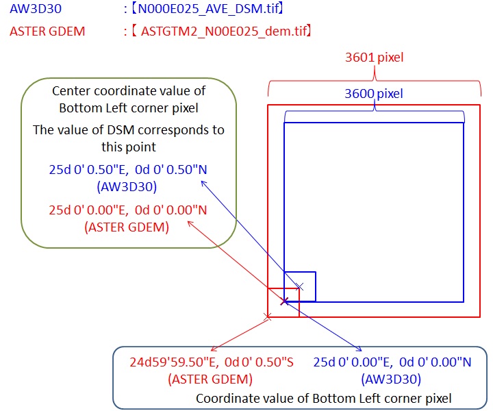
Please note that SRTM and ASTER GDEM have different definition.
The following figure shows the outline of the difference between AW3D30 and ASTER GDEM grid.
The value of the elevation of each pixel is a representative value at the center position of that pixel.
There is zero in the "STK" file, what does it mean?
+
Zero means that there is no PRISM data to calculate the elevation of that pixel.
Other auxiliary DEM data was adopted to the point.
You can know what DEM was used referring to "MSK" file.
How do you determine land / sea extents?
+
We determined land/sea extents using external coastline vector data and PRISM image.
SWBD and GSHHG were used for version 1.0, 1.1 and 2.1.
JGI and OpenStreetMap coastline data for version 2.2.
What is the difference between DEM, DTM and DSM?
+
DEM (digital elevation model) is the most general term for topographic digital data including DTM and DSM.
DTM (digital terrain model) is a word especially refers to data of bare earth, that is, the heights data not including objects on the ground.
In contrast, DSM (digital surface model) refers to data of the heights including objects on the ground such as buildings and vegetation.
Although AW3D30 is DSM, can you provide some DTM products?
+
We have no DTM product. EORC creates only DSM as AW3D30.
In addition to the product on the web site, could you provide products which have higher spatial resolution or digits after decimal point?
+
The web site provides only free-of-charge products of ALOS series missions.
Please contact the following data provider if you wish to have those products.
Let me know the details of the AW3D30 product.
+
Please refer to the following document.
How are ice shelves in Antarctica treated?
+
Ice shelves are originally land ice that has been pushed out to sea and floats seamlessly from land to sea. Therefore, the place where the ice shelves are located is not land but sea. But they are treated the same as land without a sea mask. Because they are connected to the land and can be several tens of meters above the sea surface.
The position of the ice shelf edge is not constant. Therefore, please note that the location of the ice shelf edge may differ between the sea mask based on OpenStreetMap and the DSM based on satellite data.
Some spikes and hollows were found in AW3D30 products. What is the cause of it?
+
The cause of these anomalous values is not one, however most of them are "low correlation".
The DSM is created from images captured by optical sensor onboard satellite. The images are processed using a method like aerial photogrammetry.
If the surface is covered by low contrast materials, such as water, snow and ice, the correlation between images becomes low. This induces mismatch of images, and as a result, spikes or hollows appears at that place.
The mask file which is included in AW3D30 dataset has sea mask information.
Does it include lakes/ rivers information?
+
No. Sea mask information is for sea areas only.
The source of the coastline information is referred from GSI(※) Coastline (Japan) and Open Street Map coastline (World).
GSI : Geospatial Information Authority of Japan