ページの先頭です。
本文へジャンプする。
【Important Notices】This page is an archive page of information published in the past. Since the update has been completed, it may contain broken links or outdated information. For the latest information, please use the new site Earth-graphy (earth.jaxa.jp).
ここからサイト内共通メニューです。
サイト内共通メニューを読み飛ばす。
サイト内共通メニューここまで。
ここから本文です。

Seen from Space 2009


Moscow – The City Centered on The Kremlin


  • caption on
  • caption off
Fig.1 Moscow and Vicinity

Figure 1 depicts the urban area of Moscow, the capital of the Russian Federation. The dark Moskva River meanders in the lower half of the figure, flows from left to right, joins the Volga, and empties into the Caspian Sea. Every year, it freezes in November or December and begins to thaw in late March. (Fig.1 is a summer image.)
The first record of Moscow appears in 1147 when the prince Vladimir Yuri Dolgoruki held an assembly there, thus indicating a history of over 860 years. The capital was relocated to Saint Petersburg (formerly Leningrad), but returned to Moscow in 1918 as a result of the Russian Revolution. Since the collapse of the Soviet Union in 1991, Moscow has been the capital of the Russian Federation. At the same time, it is a federal city composing the Russian Federation as its developing center of politics, economy, and culture.
The green triangle in the center of the figure by the Moskva River is the Moscow Kremlin (or simply The Kremlin). Thoroughfares radiate outwards to intersect with a sequence of circular roads ("rings"), which reveal that the city has expanded from The Kremlin. Almost circular, the Sadovoye Kal’so Ring Road is clearly visible in the figure. The outer 35 km-long Third Ring Road ran along the city border of 1980’s.

Two white domes located about 3.5 km north of The Kremlin are the Olympic Stadium, the largest indoor stadium in Russia. The white elliptical building located about 5.5 km southwest of The Kremlin is the Luzhniki Stadium, which can accommodate and audience of more than 100,000. It was once called the Lenin Stadium and was the main venue of the Moscow Olympics in 1980. It is now often used for football games. The finals of the UEFA Champions League 2007-08 were held here in May 2008. It is set to be used as a main stadium of the 14th World Championships in Athletics in Moscow in 2013.

On the right bank of the Moskva River at the bottom of the figure is the historic park and nature reserve called Kolomenskoye. It was the royal estate of the successive Tsars, such as Ivan the Terrible (Ivan IV of Russia) and Peter the Great. The Church of the Ascension, Kolomenskoye, built in 1532, is the oldest stone architecture now existing in Russia and was added to the World Heritage List of the United Nations Educational, Scientific, and Cultural Organization (UNESCO) in 1994.

  • caption on
  • caption off
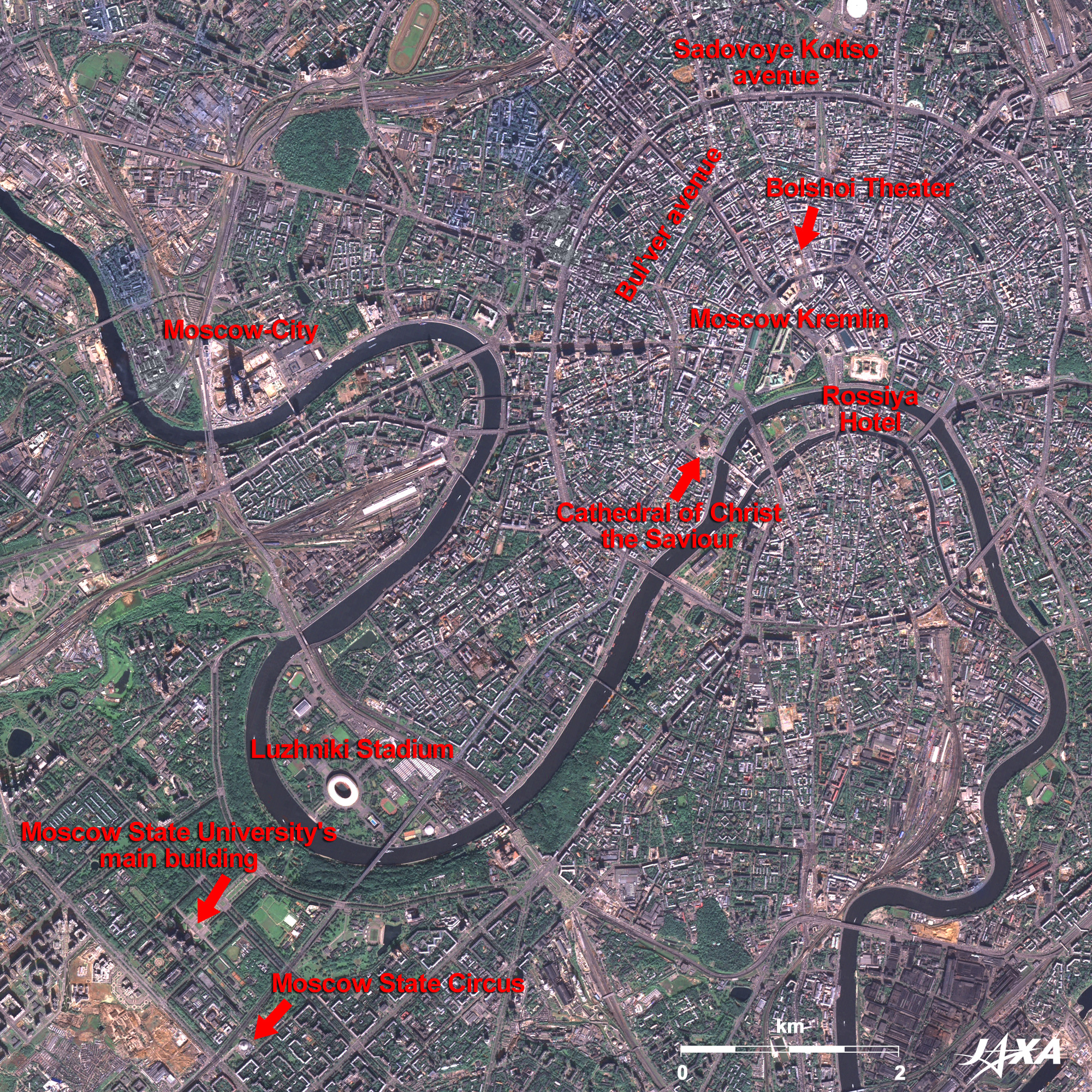
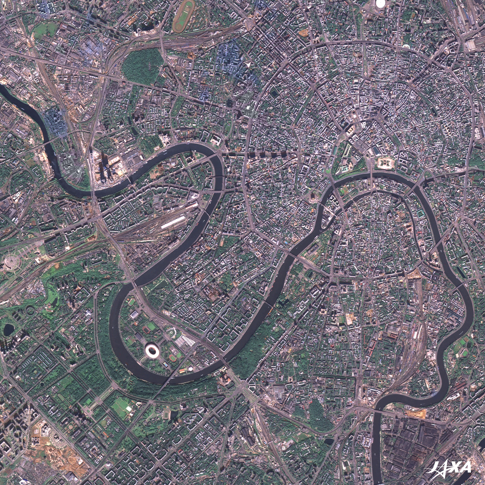
Fig.2 Urban Area of Moscow
Moscow(kmz, 1.73MB, Low Resolution) as seen on Google Earth.

A close-up view of the urban area of Moscow shows the Bul’var Avenue Ring Road with some green center dividers inside the Sadovoye Kal’so Ring Road.
The white square located in the east of The Kremlin is the site of the former Rossiya Hotel. It was a huge hotel built between 1964 and 1968 with a floor area of 4 hectares, but its services were suspended at the end of 2005 and was demolished the following March. Only the National Central Concert Hall, which seats 2,500, remains. A new amusement complex facility is planned to be built here.

The urban renewal project, "Moscow International Business Center or Moscow City" is in progress on the left bank of the Moskva River, just inside the Third Ring Road, about 5 km west of The Kremlin. Some high-rise buildings are already completed and their shadows are visible there. The 612-meter-tall and 118-story super-high-rise Russia Tower under construction will be the second tallest of the world next to the Burj Dubai, but construction was suspended in November 2008 due to the economic crisis.

On the opposite bank of the river, across from Luzhniki Stadium, is M.V. Lemonosov Moscow State University, which overlooks the city and is located in the green area, called Sparrow Hills. The headquarters of the famous Bolshoi Moscow Circus, which often came on tour to Japan, is also close to the university.

  • caption on
  • caption off
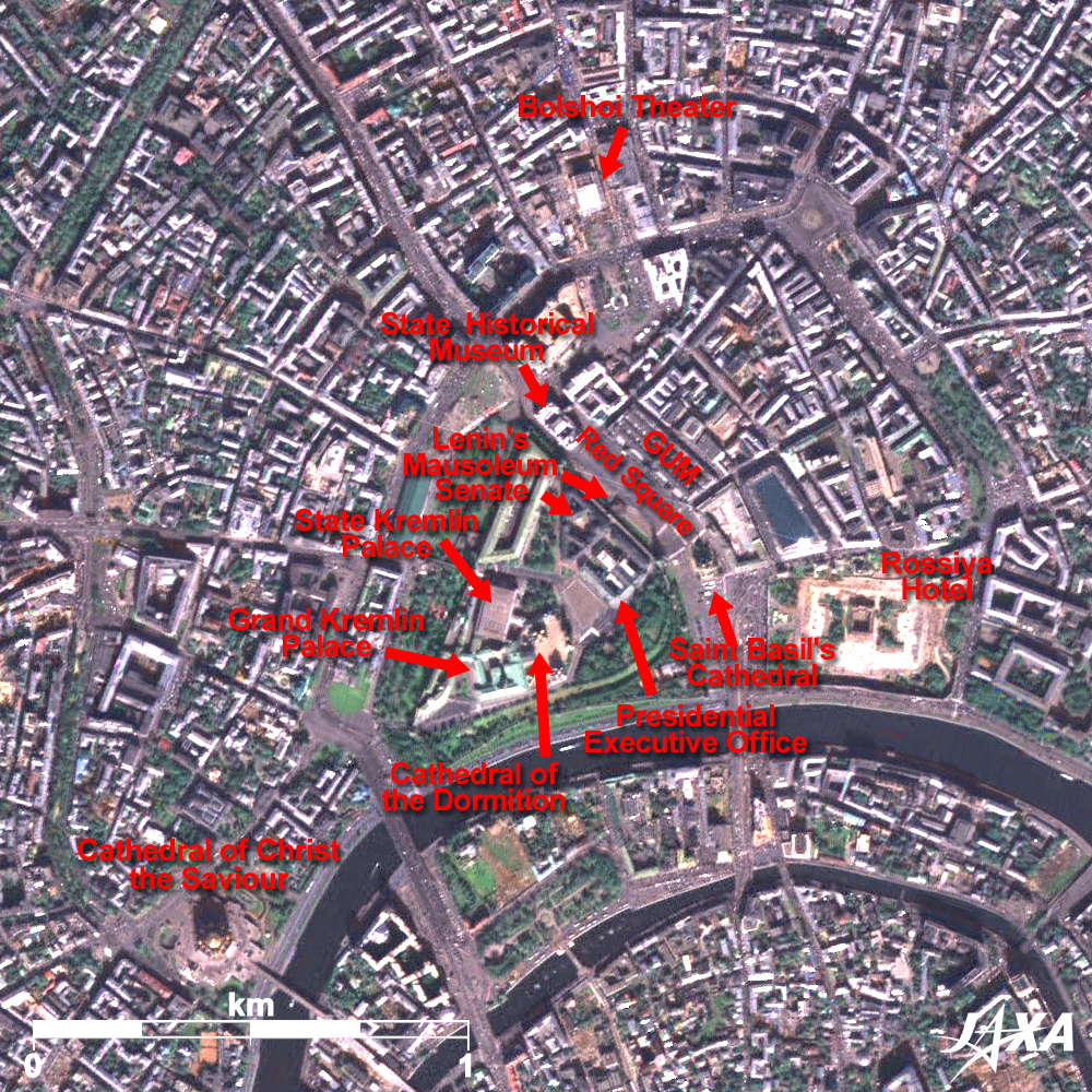
Fig.3 Vicinity of The Kremlin and the Red Square

Figure 3 presents a close-up image of The Kremlin, the Red Square, and their vicinity. While kremlins (meaning "citadel or fortified complex") exist in many cities, the Moscow Kremlin, more than 2 km around, is the most renowned and the largest. As well as housing central governmental organizations, many buildings collected here are the essence of the Russian beauty of medieval times, such as the Grand Kremlin Palace, Uspensky Sobor Cathedral (Cathedral of the Dormition), and others. These were the Tsar’s residence in the period of the Russian Empire, and after the Russian Revolution, they were used as the Supreme Soviet, which represented the Soviet Government.

The Red Square ("Red" meaning "being beautiful" in old Russian) is located outside of the northeast wall. This is the place where images or films typically demonstrating the power and political events of the Soviet Union were disseminated to the world. Famous Saint Basil’s Cathedral, with its onion-head-shaped towers on colorful roofs, the red brick State Historical Museum, Lenin Mausoleum, and the National GUM Department Store (among others) are located around the square. It is crowded with tourists all day long. UNESCO added "Kremlin and Red Square, Moscow" to the World Heritage List in 1990.
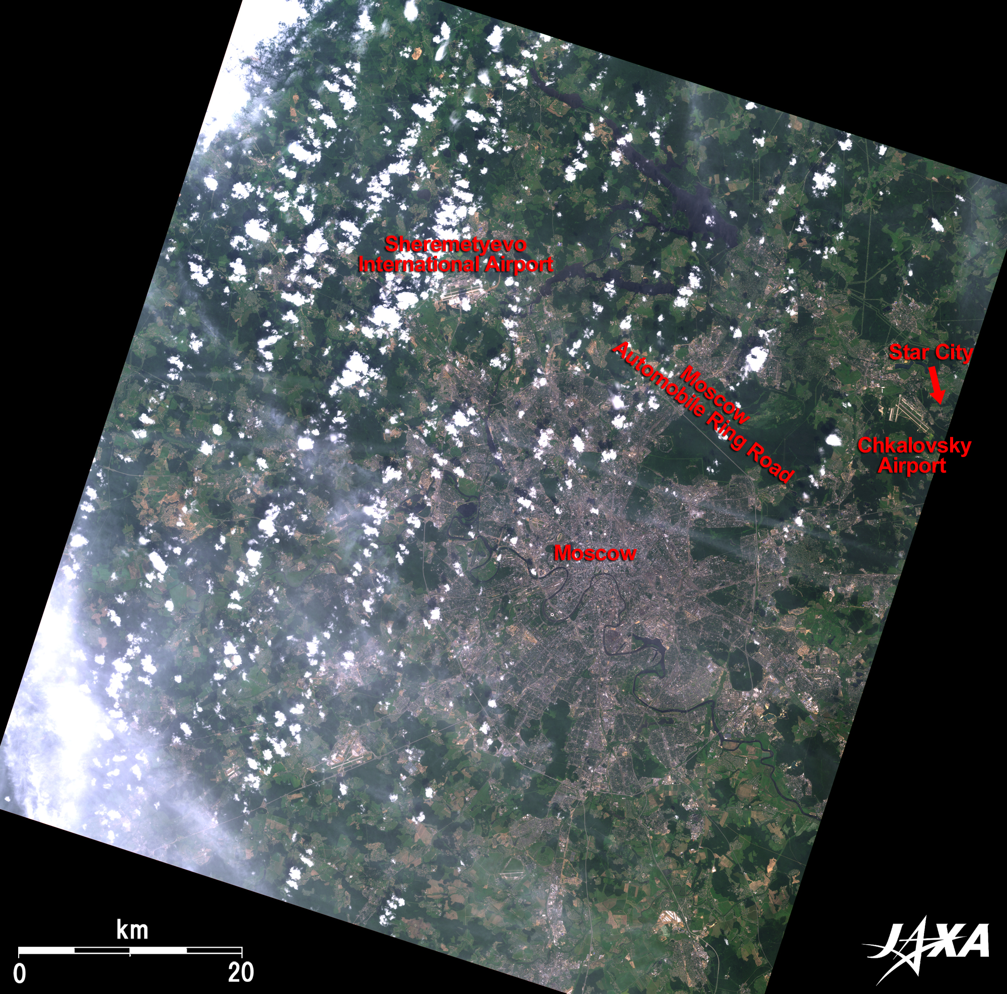
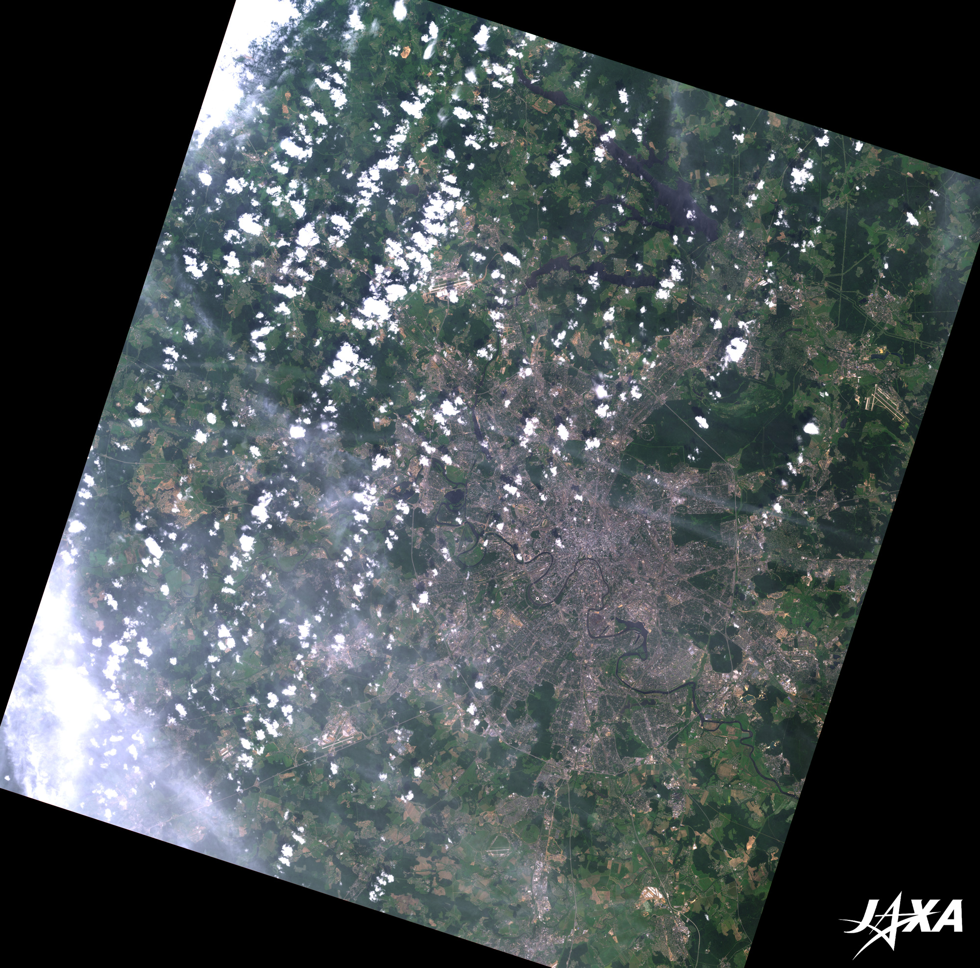
Cathedral of Christ the Savior, with a 103-meter-tall golden dome on the top, is visible by the river from the southwest of The Kremlin. It was completed in 1883 after 44 years of construction, but Stalin blew it up in 1931. Reconstruction of the cathedral started in 1997 as a symbolic and eye-catching project of the new Russian Federation commemorating the 850-year anniversary of the capital foundation and was completed in 1999.
Bolshoi Theater, renowned for its performances in ballet and opera, is not far from The Kremlin. This theater is, however, now under reform, so they give their performances at the State Kremlin Palace (Kremlin Palace of Congresses), which can accommodate an audience of 6,000.

  • caption on
  • caption off
Fig.4 Full Image

Figure 4 presents the full image of Moscow and its vicinity. While, unfortunately, white clouds and thin clouds hide some of the image, the outermost Moscow Automobile Ring Road and Sheremtyevo International Airport are visible. The Moscow Automobile Ring Road is a 109 km-long asphalt-paved motor highway completed in 1961. The Sheremtyevo International Airport is the second largest airport in Russia in handling passengers and cargo. It is also the hub airport of Aeroflot Russian International Airlines.

There are also some space-related institutions in the vicinity of Moscow.
Star City, where many Russian astronauts live with their families, is also visible in figure 4. Gagarin Cosmonauts Training Center (GCTC) is colocated in this city, where astronauts have had training here since the 1960s. The city was hidden away from the outer world and isolated during the age of the Soviet Union, but today, people can enjoy the Museum of Space Travel and Human Exploration and other recreation facilities there.
Also visible in Figure 1 are The Institute for Biomedical Problems, which organized the long-term human isolation experiment in 1999 (the Japanese Space Agency (formerly NASDA) participated in this experiment to simulate astronauts long-term-stays in the International Space Station (ISS)), and Khrunichev Space Center, which manufactures Proton Launch Vehicles.


Explanation of the Images:


(Click the images twice to enlarge.)
Satellite: Advanced Land-Observing Satellite (ALOS) (Daichi)
Sensor: Advanced Visible and Near Infrared Radiometer-2 (AVNIR-2)(Figs. 1, 2, 3, and 4) and
Panchromatic Remote-Sensing Instrument for Stereo Mapping (PRISM)(Figs. 1, 2, and 3)
Date: 0845(UTC) on July 8, 2008 (AVNIR-2)
0846(UTC) on September 19, 2007 (PRISM)
Ground resolution: 10 m (AVNIR-2) and 2.5 m (PRISM)
Map Projection: Universal Transversal Mercator (UTM)

(Figs. 1-4)
AVNIR-2 has four observation bands. The composite images are usually produced by assigning red to Band 3 (610 to 690 nm), green to Band 2 (520 to 600 nm), and blue to Band 1 (420 to 500 nm). In the above figure, green is assigned to the sum of 90% of Band 2 and 10% of Band 4 (760 to 890 nm), which improves the visibility of vegetation. The resulting images have natural coloring as if seen by the naked eye. Thus, the following colors designate ground objects:

Green: Forests
Light green: Glass fields or farmlands
Grey: City area
White: Buildings or clouds
Brown: Bare ground
Dark blue: Water surfaces

(Figs. 1-3)
PRISM is an optical sensor for observing ground surfaces with visible and near-infrared signals in the 520 to 770 nano-meter (one-billionth of a meter) band. The acquired image is monochrome. PRISM has three independent optical systems (telescopes) to acquire images for nadir, forward, and backward views at the same time. Only the nadir image was used in this article.
The above AVNIR-2 composite image was then transformed into hue, saturation, and intensity, and the intensity was replaced by the PRISM image. The hue, saturation, and intensity data were then reversed into a color image. As a result, a virtual 2.5-m ground-resolution color image was obtained. This kind of high-resolution color image, composed by combining the higher resolution monochrome image and the lower resolution color image, is called a pan-sharpened image.

本文ここまで。
image:Satellite Navigator
image:Satellite Applications and Operations Center(SAOC)
Earth Data Collection by JAXA Satellites
image:ページTOP